![]()
Prev Page--Introduction || Next Page--Geology
Geography
Topography and Drainage
Cheyenne County has two distinct types of topography: the flat to gently undulating upland plain in the areas east, northeast, south, and southwest of Bird City (Pl. 3A), and the rugged, deeply dissected uplands along the northern border of the county (Pls. 3B, 3C, and 4A) and along the valley of South Fork. On Plate 1 the topography in the Bird City area is indicated by the absence of drainage lines and the presence of numerous undrained depressions; the development of the drainage indicates to some extent the degree of dissection of the northern part of the county and the area just south of South Fork. The surface of the plains slopes gradually eastward at the rate of about 10 feet to the mile. The lowest point in the county has an altitude of approximately 3,000 feet where South Fork enters Dundy County, Nebraska. Several localities along the southern border of T. 5 S., R. 42 W. have altitudes of more than 3,800 feet. The maximum relief, therefore, is about 800 feet. The local relief ranges from about 10 feet in the Bird City vicinity to more than 300 feet in the deeply dissected area in the northern part of the county. The local relief along South Fork is as much as 200 feet.
Plate 3--A, Flat upland-plains topography looking west toward Bird City along road between secs. 28 and 33, T. 3 S., R. 37 W. B, Valley eroded in loess of the Sanborn formation in SW sec. 6, T. 1 S., R. 39 W. Pierre shale toped by thin Ogallala formation crops out at base of some of the bluffs. C, Loess hills of the Sanborn formation in northern Cheyenne County. View is northwest from SW sec. 11, T. 1 S., R. 40 W.
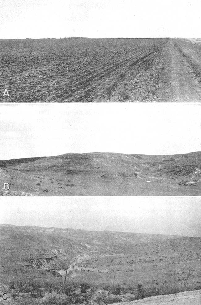
Plate 4--A, Deeply dissected valley in loess of the Sanborn formation in northern Cheyenne County. Pierre shale crops out at bottom of cut. View northeast from SW sec. 11, T. 1 S., R. 40 W. B, Channel of South Fork in southwestern Cheyenne County. View is east from bridge in sec. 34, T. 4 S., R. 42 W.
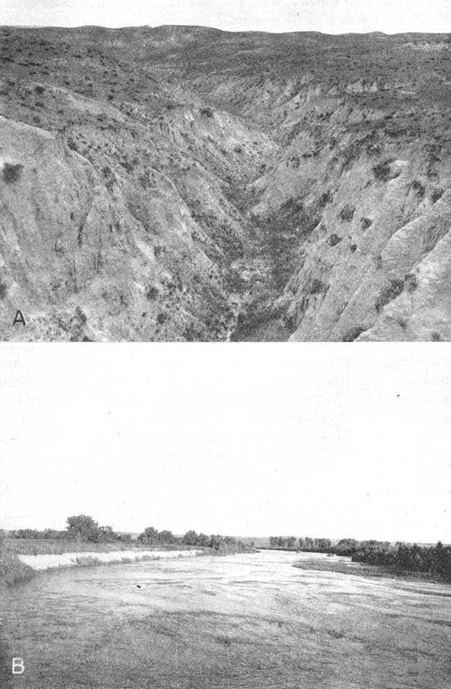
South Fork, which with its tributaries drains most of Cheyenne County, rises in eastern Colorado and enters Cheyenne County about 6 miles north of the Sherman County border. It flows northeastward across the county and enters Nebraska about 8 miles west of the Rawlins County line. The valley floor of South Fork in Cheyenne County ranges in width from about 1 to 1.5 miles (Pl. 4B). Arikaree River, which rises in eastern Colorado, flows across the extreme northwest corner of Kansas, drains a small area in northwest Cheyenne County, and joins North Fork Republican River near Haigler, Nebraska, to form Republican River. From this confluence the Republican flows eastward and is joined by South Fork near Benkelman, Nebraska. Some of the major tributaries to South Fork in Cheyenne County are Hackberry, Cherry, Big Timber, and Sand Creeks.
Little Beaver Creek is an ephemeral stream-that is, it flows only during and after heavy rains. The creek enters the county about 7 miles east of the Colorado border, runs roughly parallel to the Sherman County line for several miles, and flows northeastward as it crosses into Rawlins County. Beaver Creek, sometimes called Wet Beaver, has a small perennial flow as it crosses the southeast corner of the county.
Climate
The climate of Cheyenne County is semiarid, being characterized by light to moderate precipitation, abundant sunshine, and a high rate of evaporation. The heat of the summer days is relieved to some extent by good wind movement and low relative humidity. Summer nights are generally cool. The normal annual mean temperature at St. Francis is 52.1° F. The highest normal monthly mean temperature is 77.3° F. in July, and the lowest normal monthly mean temperature is 28.0° F. in January. The highest temperature on record is 111° F., which was first recorded on July 24, 1936. The lowest temperature recorded at St. Francis is -28° F., which occurred on January 12, 1912. The growing season averages 160 days, ranging from 194 to 132 days. Killing frosts have occurred as late as May 29 and as early as September 21.
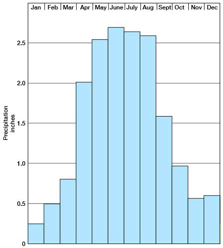
The normal annual precipitation at St. Francis, determined by the U. S. Weather Bureau, is 17.86 inches; the average annual precipitation during the period 1908 to 1950 is 20.30 inches. The precipitation has ranged from a low of 11.69 inches in 1910 to a high of 33.20 inches in 1923. More than half the precipitation falls during the growing season from May through September, when moisture is needed most. The annual precipitation and the cumulative departure from normal precipitation at St. Francis are shown in Figure 3, and the normal monthly precipitation is shown in Figure 4.
Fig. 3--Graphs showing annual precipitation and cumulative departure from normal precipitation at St. Francis.
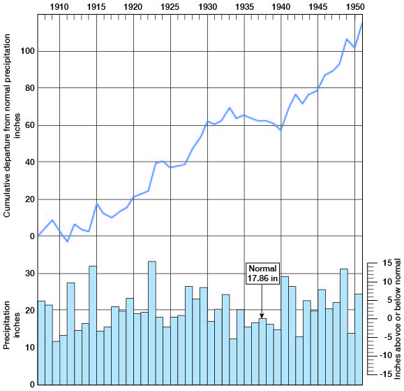
Fig. 4--Graph showing the normal monthly precipitation at St. Francis computed from records covering the period 1908-1942.
Population
According to the 1950 Federal census the population of Cheyenne County was 5,668 [Note: Cheyenne County population was listed as 3,165 in 2000 U.S. census, with a population per square mile of 3.1 (KU Institute for Policy & Social Research).]. The average density of population was 5.5, as compared with 23.2 for the entire State. In 1890 the population was 4,401 but by 1900 it had dropped to 2,640. In 1930 the population was up to 6,942, the greatest number ever officially recorded by the Census Bureau. In 1940 the population was 6,221.
St. Francis, the county seat, had a population of 1,041 in 1940 and 1,892 in 1950 [1,497 in 2000]. Bird City had 694 inhabitants in 1940 and 784 in 1950 [482 in 2000]. Cheyenne County ranks 83d in population within the State [90th in 2000].
Transportation
Cheyenne County is served by a branch line of the Chicago, Burlington and Quincy Railroad, which leaves the main line at Orleans Nebraska, parallels Beaver Creek to Atwood in Rawlins County, continues west to Cheyenne County passing through Bird City and Wheeler, and terminates at St. Francis. The north part of the county is served also by the main line of the Chicago, Burlington and Quincy Railroad, which runs across the southern part of Dundy County, Nebraska.
U. S. Highway 36 passes through the center of Cheyenne County from east to west. State Highway 27 runs north from Sherman County and joins U. S. Highway 36 half a mile south of Wheeler. The highways are concurrent from this point to about a mile west of St. Francis, where Highway 27 turns northward toward Haigler, Nebraska. This northern reach of Highway 27 is not paved but is well graveled. Many of the county roads are graveled and are kept in good condition throughout the year. Most of the township roads have been graded.
Agriculture
Agriculture is the chief occupation in Cheyenne County. According to the census of 1950 there were 817 farms in 1950 and 218,760 acres of major crops were harvested. About 72 percent of the cultivated acreage in 1950 was used for the production of. wheat. Much of the land area is in pasture, and cattle raising is a major occupation. The acreage of principal crops grown in 1950 is shown in Table 1.
Table 1--Acreage of principal crops grown in Cheyenne County, Kansas in 1950.
| Crop | Acreage | |
|---|---|---|
| Wheat | 158,000 | |
| Corn | 17,900 | |
| Oats | 680 | |
| Barley | 3,070 | |
| Rye | 420 | |
| Sorghum: | ||
| For grain | 12,600 | |
| For forage | 20,430 | |
| For silage | 1,020 | |
| Potatoes | 10 | |
| All | 4,630 | |
Mineral Resources
In 1951 two wildcat oil test wells were drilled in Cheyenne County. One of these wells in the SE SE NW sec. 26, T. 1 S., R. 39 W. found oil in what may prove to be commercial amounts. This oil pool, which is known as the Judy pool, is temporarily abandoned. The results of the 1951 prospecting were apparently encouraging because several test wells have been drilled in 1952. [For current information on oil and gas production, see the Survey's oil and gas page for Cheyenne County.]
With the possible exception of oil and gas, Cheyenne County has no mineral resources of great economic importance other than ground water and the fertile soil. A small amount of sand and gravel from the alluvium of South Fork is used for road surfacing material. Samples of the Pierre shale have been analyzed for oil and gas content as potential oil-shale reserves in the geochemistry laboratory of the State Geological Survey at Lawrence, but no oil was found and there was only a minute quantity of gas.
Prev Page--Introduction || Next Page--Geology
Kansas Geological Survey, Geology
Placed on web Aug. 8, 2008; originally published April 1953.
Comments to webadmin@kgs.ku.edu
The URL for this page is http://www.kgs.ku.edu/General/Geology/Cheyenne/03_geog.html