


Kansas Geological Survey, Open-File Rept. 96-1a
Proposed Management Areas--Page 4 of 16
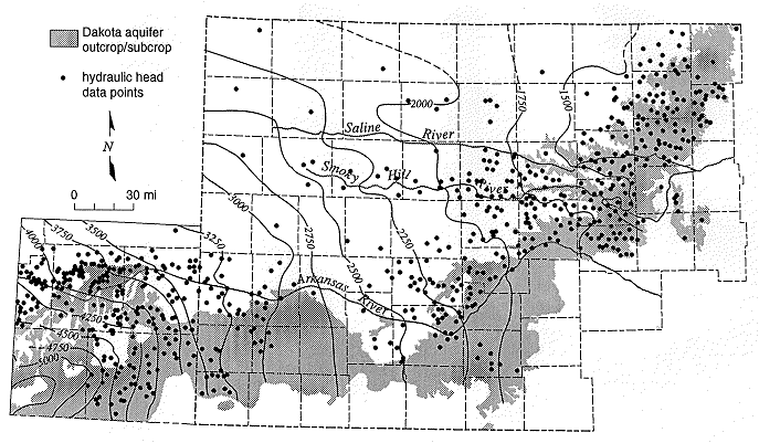
Figure 2. Elevation in feet above mean sea level of the pre-development potentiometric surface of the Dakota aquifer in southeastern Colorado and western Kansas.
Only about 10% of the infiltrated water entering the aquifer moves downdip from the recharge area south of the Arkansas River into areas where the Upper Cretaceous aquitard overlies the Dakota in western Kansas and southeastern Colorado (Macfarlane, 1993). The ground-water moves slowly northeastward towards the regional discharge area in central Kansas due to low aquifer transmissivity. Over most of western Kansas, the vertical hydraulic conductivity of the overlying Upper Cretaceous aquitard is very low and restricts freshwater recharge to the Dakota. Freshwater recharge is less than 1% of the lateral flow within the aquifer where the aquitard is thick (Smith and Macfarlane, 1994). Recharge rates are higher where the aquitard is relatively thin and dissected near the outcrop/subcrop areas and may be as much as 10% of the lateral flow within the aquifer. In central Kansas, an additional source of recharge to the Dakota comes from the underlying Cedar Hills Sandstone where both aquifers are hydraulically connected. The total recharge from this source amounts to less than 1% of the lateral flow in the upper Dakota aquifer.
The potentiometric surface map in Figure 2 indicates that the hydraulic head in the Dakota aquifer is lower in north-central Kansas than elsewhere. Ground water in the Dakota moves toward the river valleys in central Kansas and discharges to streams-aquifer systems. In the outcrop areas of central Kansas, the flow system in the Dakota is influenced by both regional flow from the Dakota to the west and local flow systems that result from local topographic relief. These local systems are replenished by infiltration of local recharge which may be discharged from the aquifer only a short distance away. Also, pumping test results suggest that the Dakota is generally more permeable in this region than it is to the west. Computer simulations of the steady-state flow system indicate that the flux of freshwater through the outcrop/subcrop belt is at least an order of magnitude higher than in the confined aquifer to the west. The annual recharge to the Dakota is estimated to be on the order of tenths of an inch. As a result, fresh and saline water springs and seeps can be found in the river valleys.
Salt marshes associated with discharge to surface water are common features in the Saline, Solomon, and Republican River valleys of north-central Kansas. During low flow periods when baseflow constitutes the bulk of stream discharge, the chloride concentration of surface waters escalates rapidly. Elsewhere, freshwater is discharged from the upper Dakota to the Arkansas, Pawnee, and Wet Walnut drainages.
Previous page--Other Significant Aquifer/Aquitard Units ||
Next page--Water Quality
Start of this report ||
Table of Contents