Kansas Geological Survey, Current Research in Earth Sciences, Bulletin 254, part 1
Back to Methods...
![]()
![]()
![]()
Kansas Geological Survey, Current Research in Earth Sciences, Bulletin 254, part 1
Back to Methods...
![]()
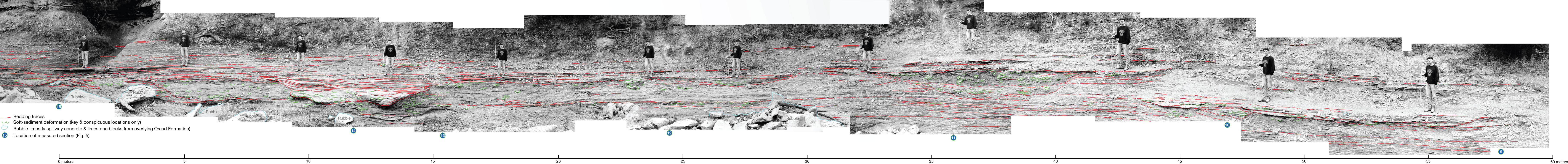
Figure 7--Correlation of key beds in the upper interval of exposure at Lone Star spillway. North is to the right. Circled numbers at the bottom indicate locations of measured sections (see fig. 5). Scale staff throughout is 6 ft (1.83 m) long; the holder (S. T. Franklin) is 1.93 m tall. Mr. Franklin did not grow during the photography; the scale increases from left to right, owing to variations in distance from camera to staff and holder, necessitated by the topography. The scale near the right end is 1.6 times that at the left end; thus the horizontal scale also is variable. The scale at the bottom accurately reflects the distance from sec. 9 to sec. 15, but not the distance between individual sections. It is primarily useful for locating features referred to in text. John Charlton, KGS, merged overlapping portions of the photographs using Adobe Photoshop CS3, extended version. A higher-quality version is also available as an Acrobat PDF file containing the oversize figures 5 and 7.
Kansas Geological Survey
Placed online July 16, 2008
http://www.kgs.ku.edu/Current/2008/Enos/fig3.html
email:webadmin@kgs.ku.edu