Kansas Geological Survey, Current Research in Earth Sciences, Bulletin 254, part 1
Prev Page--Start || Next Page--Results and Interpretations
![]()
![]()
![]()
Kansas Geological Survey, Current Research in Earth Sciences, Bulletin 254, part 1
Prev Page--Start ||
Next Page--Results and Interpretations
![]()
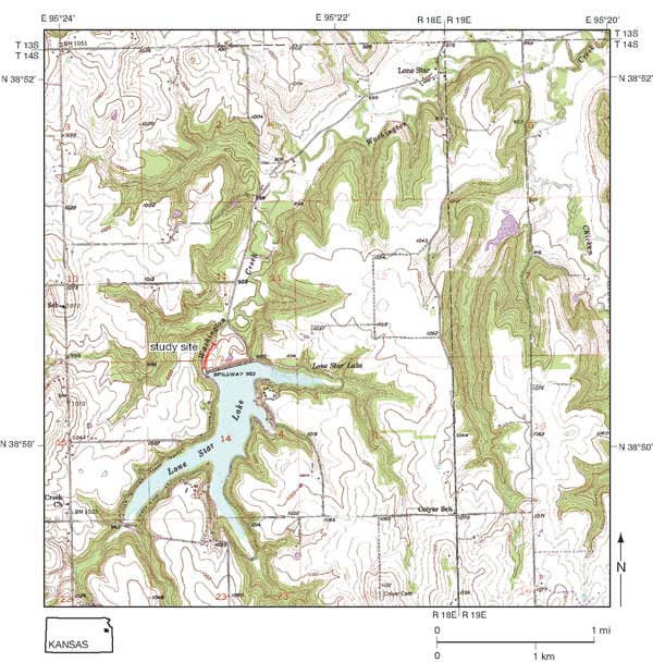
The upper part of the Ireland Sandstone Member of the Lawrence Formation exposed in the spillway of Lone Star Lake, 9 mi (14.5 km) southwest of Lawrence, Douglas County, Kansas (fig. 1), is a sequence of shale, siltstone, and sandstone with many deformed intervals. Primary sedimentary structures and deformational structures provide clues as to depositional environment and processes. Measurement and correlation of the structures at the Lone Star spillway were undertaken to improve understanding of these processes and environments. The resulting interpretations support, and to some extent modify, existing theories on the depositional history of the upper part of the Ireland Sandstone Member.
Figure 1--Location of the study area in the spillway of Lone Star Lake. Spillway connects to Washington Creek below the dam. Base maps are from the Lone Star and Globe sheets, U.S. Geological Survey 7.5-min topographic quadrangles.
The Lawrence Formation of the Douglas Group (Upper Pennsylvanian, Stephanian) forms the base of the Virgilian Series as it is now interpreted (figs. 2 and 3). The Lawrence Formation consists chiefly of gray claystone, mudstone, siltstone, and sandstone, which weather yellowish gray, and small intervals of red claystone, coal, gray limestone, and conglomerate (Ball, 1964; Zeller, 1968; Rutan, 1980). The formation extends from the base of the Haskell Limestone Member to the base of the Toronto Limestone Member of the Oread Formation (fig. 2). The study interval, beneath the lower Williamsburg coal, technically belongs to the Ireland Sandstone Member (fig. 2), but it has little in common with the namesake channel-form sandstone, lithologically and perhaps genetically. The sandstone channel is 100 ft (30 m) thick in southern Douglas County where it cuts deep into the Weston Shale Member (O'Connor, 1960) and 160 ft (50 m) thick in adjacent Franklin County (Sanders, 1959), but becomes thinner and more shaly in central and northern Douglas County until it "cannot be differentiated" (O'Connor, 1960, p. 36).
Figure 2--Stratigraphic nomenclature of the Douglas Group and adjacent units (modified from Feldman et al., 2005, and Archer and Feldman, 1995; after Zeller, 1968). The study interval is in the upper part of the Ireland Sandstone Member of the Lawrence Formation and extends through the lower Williamsburg coal. The study site lies north of the main channel incision of the Ireland, exposed in southern Douglas and northern Franklin counties. The Ireland Sandstone Member extends to the base of the Amazonia Limestone Member and thus includes the lower Williamsburg coal (Ball, 1964, p. 142). The Amazonia Limestone Member and an overlying thin coal, presumably the upper Williamsburg coal (fig. 3), are still exposed at the site, whereas the study interval has been entirely covered by a concrete apron.
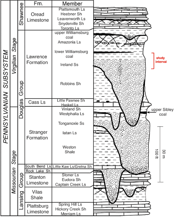
Figure 3--Stratigraphic cross section of the Douglas Group in northeastern Kansas (from Moore, 1949; after Bowsher and Jewett, 1943). The Robbins Shale and Haskell Limestone Members are included in the Stranger Formation, rather than in the Lawrence Formation (Zeller, 1968) or the Cass Limestone (fig. 2; Feldman et al., 2005). A larger version of this figure is available.
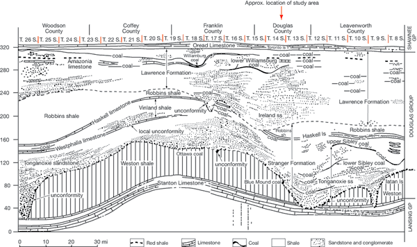
The Lone Star spillway, "The Grand Canyon of Douglas County" (nom. nov.), exposed approximately 27 m of the uppermost Lawrence Formation following severe erosion during a flash flood of 30 June 1988, when up to 12.2 inches of rain fell in the area (Lawrence Journal-World, 30 June 1988). The lower 10.5 m of the section, the focus of this study, underlies a coal bed that Bowsher and Jewett (1943, p. 52) and Lanier (1993, p. 4-8) correlated with the lower Williamsburg coal (fig. 3). This entire interval was covered by a thick layer of concrete when the spillway was rebuilt in 1997.
Stanton Ball (1964) provided by far the most detailed study of the Douglas Group in Kansas, before there was adequate exposure at Lone Star Lake. Sanders (1959) and O'Connor (1960) provided important stratigraphic details for northeastern Kansas and Douglas County, respectively. Studies by Rutan (1980), Archer (1991, 1993), Archer and West (1991), Lanier (1993), Archer et al. (1994), Joeckel (1994, 1995), and Archer and Feldman (1995) dealt with the sedimentology at or near the Lone Star site. Lanier (1993, p. 4-6) described the section below the lower Williamsburg coal as a coarsening-upwards succession of pinstripe- and lenticular-bedded mudstones; flaser-bedded, fine-grained, micaceous sheet sandstones; and channels with accretionary fillings marked by inclined, heterolithic bedding and convoluted bedding. Lanier interpreted the section as a shoaling-upwards, prograding, muddy tidal-flat sequence with a repetitive depositional style characterized by a continuum of punctuated (waning-energy) sedimentation events (1993, p. 4-9).
Lanier (1993) observed that channel-form sandstones below the lower Williamsburg coal exhibit climbing-ripple drift lamination in a finer-grained facies that consists of lenticular- and flaser-bedded, heterolithic sandstones and shales. This part of the section is interpreted as a tidal deposit (Archer and West, 1991, p. 89; Archer et al., 1993; see also Lanier and Tessier, 1998). The Lawrence Formation immediately above the lower Williamsburg coal consists of rhythmic silt and shale laminae with systematic thickness variations interpreted as neap-spring tidal cycles (Archer, 1991, 1993, p. 2-21–2-23).
West and Maples (1993, p. 7-6) summarized the paleoecology of the Douglas Group and "suggest that the Douglas Group represents a range of environments from nearshore marine to freshwater and terrestrial...." Trace fossils are locally numerous in the Lawrence Formation (Hakes, 1972, 1976; Robb, 1991; Garbish et al., 1991; Lanier, 1993). In the bathymetric trace-fossil classification developed by Seilacher (1967), the trace fossils of the Lawrence Formation appear to fit best in the Scoyenia facies (Hakes, 1972, p. 32). Scoyenia facies indicates low-energy, restricted, nearshore deposits that may be lagoonal or possibly brackish (Hakes, 1972, p. 33). Scott Hageman (in Robb, 1991, p. 49-52) described a variety of plant fossils, some with attached spirorbid worm tubes, from the carbonaceous shale that forms the upper part of the Williamsburg coal. He concluded, "The spirorbids and plant debris were probably in a shallow, freshwater or slightly brackish environment because the spirorbids attach to the leaves and the leaves grew in that type of environment."
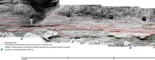
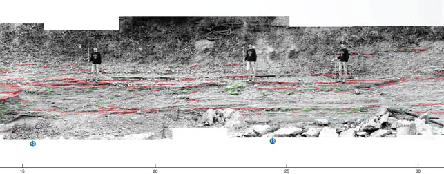
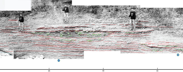
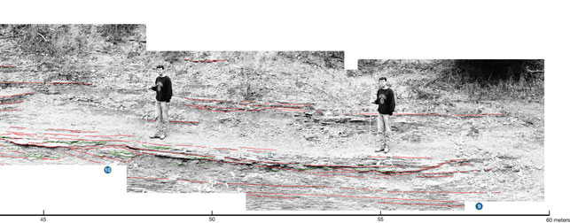
This project is based on closely spaced sections (fig. 4) measured in the spillway of Lone Star Lake (fig. 5). The outcrop is nearly separated into two intervals. Sections 1 through 7 at the north part of the spillway comprise the lower interval. The upper interval consists of sections 9 through 15 from the south. The upper interval is well exposed only on the left bank, that is, the west side of the spillway. The lower Williamsburg coal was a natural datum for correlation of the upper interval. A closely spaced sandstone couplet was a useful datum for the lower interval. It extends from section 1 into sections 9 and 10 to provide a tie with the upper interval (figs. 5 and 6). Key beds in the more intricate upper interval were initially traced in the field and eventually on overlapping panoramic photographs (fig. 7).
Figure 4--Locations of measured sections within Lone Star spillway/Washington Creek, modified from sketch map by S. T. Franklin. Spacing between adjacent sections was measured by tape measure.
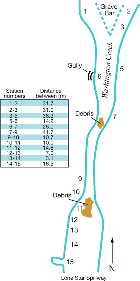
Figure 5--Correlated sections of the Lawrence Formation from the Lone Star spillway. Locations of sections are shown in fig. 4. Deformational structures noted include convolute lamination, load casts, and pseudonodules. Convolute lamination is "irregular wavy laminae confined within a single sediment layer" (Middleton, 2003). "Irregular" typically involves crumpling or oversteepening in defiance of gravity. Load casts are sole marks that deform the base of a bed, generally sandstone or siltstone overlying mudstone (Allen, 2003). "Pseunodules are a soft-sediment deformation structure comprising rounded masses of clastic sediment set in a similar or finer-grained matrix" (Owen, 2003b). In measuring sections, we tried to distinguish among load casts, pseudonodules, and ball-and-pillow structure. The intention was to apply ball-and-pillow to deformation that affected an entire layer, rather than the basal part only (Allen, 2003; Owen, 2003b). Pseudonodules were to designate isolated masses, overlain as well as surrounded by matrix, the "detached pseudonodules" of Owen (2003b). This proved impractical, owing to considerable variation in usage among individual operators and the fact that "The terminology....is highly confusing" (Owen, 2003b). In this compilation ball-and-pillow and pseudonodules were lumped together as pseudonodules. The instructor (Enos) edited each student's sections in the field. Each section was redrafted for this illustration by Enos to incorporate field edits, to include observations from both operators in sections that were measured twice (1992 and 1994), and to provide uniform representation. The sections used were measured by 1. Terrance Huettl, 2. Jon Holgren, 3. Ryan Pearson and Monica Hochanadel, 5. Matt Brookshier, 6. Glenn Newell, 7. Peter Cattaneo, 9. Gregory Siek (base) and Matthew Briney (top), 10. John Keller, 11. Merritt Forman and Lisa Armatas, 12. Robert Jefferson, 13. Victoria Glenn-Christensen, 14. Staci Goetz, 15. Doug Linger and Shiela Kortlucke. Sections 4 and 8 were not satisfactorily completed. A larger version of this figure is available; a higher-quality version is also available as an Acrobat PDF file containing the oversize figures 5 and 7.
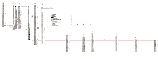
Figure 6--View of lower part of spillway at Lone Star Lake, the "Grand Canyon of Douglas County." Exposures are mainly of the lower interval. The scale (S. T. Franklin; 193 cm) is standing above a channel-form lens of shale and deformed sandstone within the upper interval (sec. 11, fig. 5; 32-41 m in fig. 7). The channel form on the right bank (arrow) is probably the same lens, suggesting an approximate ENE elongation of the channel form. This orientation is not inconsistent with the NNE-SSW paleocurrent directions measured by Lanier (1993, see fig. 11). However, this trend and a measured trend of 120° (ESE/WNW) in the channel at 8-16 m contradict Lanier's observation that the "Overall trend of the channel complex appears to be north-south" (Lanier, 1993, p. 4-8). The apparent difference in elevation of the two channel exposures is an artifact of the camera angle. Lateral continuity is good in the underlying beds on both sides of the exposure.
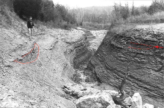
Figure 7--Correlation of key beds in the upper interval of exposure at Lone Star spillway. North is to the right. Circled numbers at the bottom indicate locations of measured sections (see fig. 5). Scale staff throughout is 6 ft (1.83 m) long; the holder (S. T. Franklin) is 1.93 m tall. Mr. Franklin did not grow during the photography; the scale increases from left to right, owing to variations in distance from camera to staff and holder, necessitated by the topography. The scale near the right end is 1.6 times that at the left end; thus the horizontal scale also is variable. The scale at the bottom accurately reflects the distance from sec. 9 to sec. 15, but not the distance between individual sections. It is primarily useful for locating features referred to in text. John Charlton, KGS, merged overlapping portions of the photographs using Adobe Photoshop CS3, extended version. A larger version of this figure is available; a higher-quality version is also available as an Acrobat PDF file containing the oversize figures 5 and 7.
The sections were measured in detail in 1992 and with considerable overlap in 1994, as part of sedimentology class projects at the University of Kansas. A selection of these sections serves as the input data for this report. Scale of the original sections is 1 inch = 25 cm, or approximately 1:10. Lithology, bedding thickness, and character were recorded graphically (fig. 5). Symbols denote primary sedimentary structures, deformational structures, and particles, including the rare fossils. Rock name, grain size, and any additional comments were noted. Each section was checked and edited in the field by the instructor (Enos). The sections were redrafted for fig. 5 to incorporate field edits, to include observations from both operators in the duplicated sections, and to provide uniform representation.
Prev Page--Start || Next Page--Results and Interpretations
Kansas Geological Survey
Placed online July 16, 2008
http://www.kgs.ku.edu/Current/2008/Enos/02_intro.html
email:webadmin@kgs.ku.edu