Kansas Geological Survey, Current Research in Earth Sciences, Bulletin 250, part 2
Prev Page--Historical Aspects, Definition || Next Page--Characteristics
![]()
![]()
![]()
Kansas Geological Survey, Current Research in Earth Sciences, Bulletin 250, part 2
Prev Page--Historical Aspects, Definition ||
Next Page--Characteristics
![]()
The Arbuckle is present in most of Kansas and is absent only in areas of northeastern and northwestern Kansas, and over ancient uplifts and buried Precambrian highs (Walters, 1946; Keroher and Kirby, 1948; Cole, 1962, 1975; Denison, 1966) (figs. 1, 2, 6). The Arbuckle is thin to absent in parts of northeastern Kansas due to pre-Simpson uplift and erosion (Newell et al., 1987). The Arbuckle is locally absent on the Nemaha uplift, Cambridge arch, and Central Kansas uplift due to pre-Pennsylvanian erosion (Walters, 1946; Jewett, 1951, 1954; Merriam, 1963). Arbuckle Group rocks occur at depths ranging from about 500 ft in southeastern Kansas to more than 5,000 ft in southwestern Kansas (Keroher and Kirby, 1948; Cole, 1975). Arbuckle Group rocks thicken as a whole from north to south and are thickest, up to 1,390 ft, in the southeastern corner of Kansas (Cole, 1975) (fig. 7).
Figure 6--Overall distribution of Cambrian-Ordovician strata (yellow area) in Kansas. Arbuckle absent in areas colored pink. From Merriam (1963).
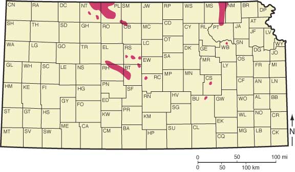
Figure 7--Isopach map of Arbuckle Group strata (base Simpson to Precambrian) from well data up to 1965. Contour interval 100 ft. From Cole (1975).
Kansas is characterized by broad basins and domes covering thousands of square kilometers. Prominent uplift and subsidence occurred episodically throughout the Phanerozoic, separated by periods of gradual deformation (Newell et al., 1989). Although the location of the structural features varied somewhat throughout the Paleozoic, there seem to be consistent patterns of repeated localized uplift and subsidence (Baars and Watney, 1991). Two prominent structural uplifts that affect the Paleozoic rocks in Kansas, the Nemaha uplift and Central Kansas uplift (CKU), represent significant Early Pennsylvanian deformation events likely associated with similarly aged plate convergence along the Ouachita Mountains orogenic belt in Arkansas (Newell et al., 1989). This uplift and erosion locally affected Arbuckle strata, especially on the Central Kansas uplift where Pennsylvanian strata directly overlie Arbuckle strata, or basement rocks where Arbuckle strata are absent. The Midcontinent Rift System and related Humboldt Fault Zone constitute a north-northeast by south-southwest-trending fault swarm that was reactivated several times during the Paleozoic. Local uplift and interstratal truncation suggest rejuvenation of structural blocks during the Late Ordovician, before the better known Pennsylvanian uplift and erosion of the major structural features (Baars and Watney, 1991).
Structural maps of Precambrian basement (fig. 8) and isopach maps (figs. 7, 9) of the Arbuckle indicate the presence of elements of the CKU and Nemaha Ridge prior to Arbuckle deposition. Deformation during and just post-Arbuckle deposition appears to have been minor. The most obvious structural feature to have developed prior to Simpson deposition is the Southeast Nebraska arch (Lee, 1956) (fig. 10), which extended into northeastern Kansas. Although not strongly evidenced, Merriam (1963) interpreted mild activity of the CKU during Arbuckle deposition. In addition, extensive differential erosion of Precambrian rocks (presumably in late Precambrian time) resulted in an irregular topography onto which Cambrian-Ordovician strata were deposited (Walters, 1946) (fig. 11).
Figure 8--Preliminary regional configuration map on top of Precambrian basement complex in Kansas. Contour interval 500 ft. From Merriam (1963).
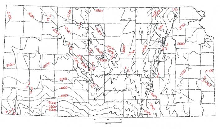
Figure 9--Isopachous map showing convergence between top of Precambrian rocks and top of Arbuckle rocks. Southeast Nebraska arch is shown by zero line in northeast. Contour interval is 250 ft. From Merriam (1963).
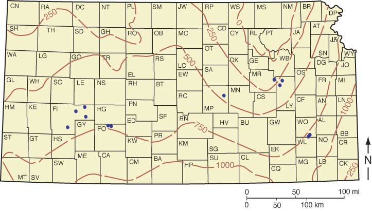
Figure 10--Maps showing principal structural features in Kansas. A) Pre-Simpson structure represented by 500-ft thickness lines of Arbuckle dolomite and Reagan sandstone. B) Structural deformation from Arbuckle through Chattanooga time. From Lee (1956).
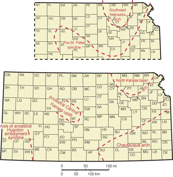
Figure 11--Cross section showing differential erosion of Precambrian basement rocks, relationship of overlying Cambrian-Ordovician strata, and karstic features associated with the upper Arbuckle unconformity surface. From Walters (1946).

Arbuckle Group rocks are part of the craton-wide Sauk Sequence, which is bounded at its base and top by major interregional unconformities (Sloss, 1963). These interregional unconformities represent major regressions of the sea and erosion and subaerial exposure of vast areas of the craton. The Sauk transgression is the first of several major transgressions in the Paleozoic Era. It began in the Late Proterozoic/Early Cambrian and continued for 100 million years, reaching a maximum in the early Ordovician. Causes of the Sauk transgression include the melting of Proterozoic ice, increased production of sea floor along the mid-ocean ridges, elevation of ridges, and subsidence of passive continental margins. As a result of these factors, sea level rose and epeiric seas (shallow continental seas) flooded the cratons. As the sea transgressed across the deeply weathered Precambrian igneous and metamorphic basement, basal mature quartz sands (blanket sands) were deposited. These sandy beach facies passed offshore to shallow-water carbonate-producing zones.
Arbuckle shallow-shelf carbonate strata in Kansas and age-equivalent strata elsewhere are part of the Cambrian-Ordovician "Great American Bank" that stretched along the present southern and eastern flanks of the North American craton (Wilson et al., 1991). The bank consists of hundreds of meters of largely dolomitized intertidal to shallow subtidal cyclic carbonate rocks overlain by a regional unconformity (Wilson et al., 1991). The shallow subtidal to intertidal environment persisted throughout Arbuckle depositional time and is reflected in the uniform composition and texture of Arbuckle Group rocks (Bliefnick, 1992).
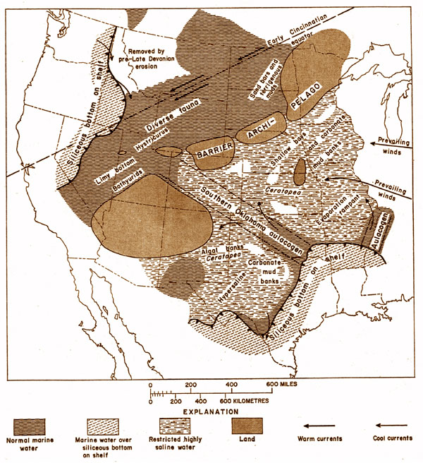
Kansas during this time was located approximately between 20 to 30 degrees south of the equator (fig. 12), and south of the Transcontinental arch (fig. 13). Early Ordovician sedimentation was different on opposite sides of the Transcontinental arch (Ross, 1976). Shallow marine limestone was deposited on the shelf to the north, and on the shelf to the south predominantly dolomite, cherty dolomite, and dolomitic limestone were deposited, represented by the Arbuckle Group in Kansas and much of Oklahoma (Ross, 1976). Ross (1976) attributes the contrast in sedimentation on opposite sides of the Transcontinental arch to differences in water depth. The shelf north of the arch was in the Ordovician tropical belt. This area likely experienced relatively heavy rainfall and low evaporation and was able to maintain normal marine salinity conditions over a somewhat deeper shelf area (Ross, 1976). The shelf south of the arch was in the Ordovician horse latitudes. This area likely experienced low rainfall and high evaporation which resulted in hypersaline water over a shallower shelf area (Ross, 1976). These latter conditions may have allowed for refluxing of magnesium-rich brines in subtidal waters over the carbonate bottom which in turn would account for the widespread dolomites on the shelf south of the arch (Harris, 1973).
Figure 12--Paleogeographic map for Early Ordovician time (470 Ma). Kansas is shown by black outlined area. Tan and brown colors reflect land surface, light blue areas are epicontinental and pericontinental seas, and dark blue represents oceanic areas. Modified from Blakey (http://jan.ucc.nau.edu/~rcb7/); used with permission of author.
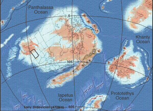
Figure 13--Interpretation of Early Ordovician paleoenvironments in the western United States. From Ross (1976); used with permission of University of Wales Press.
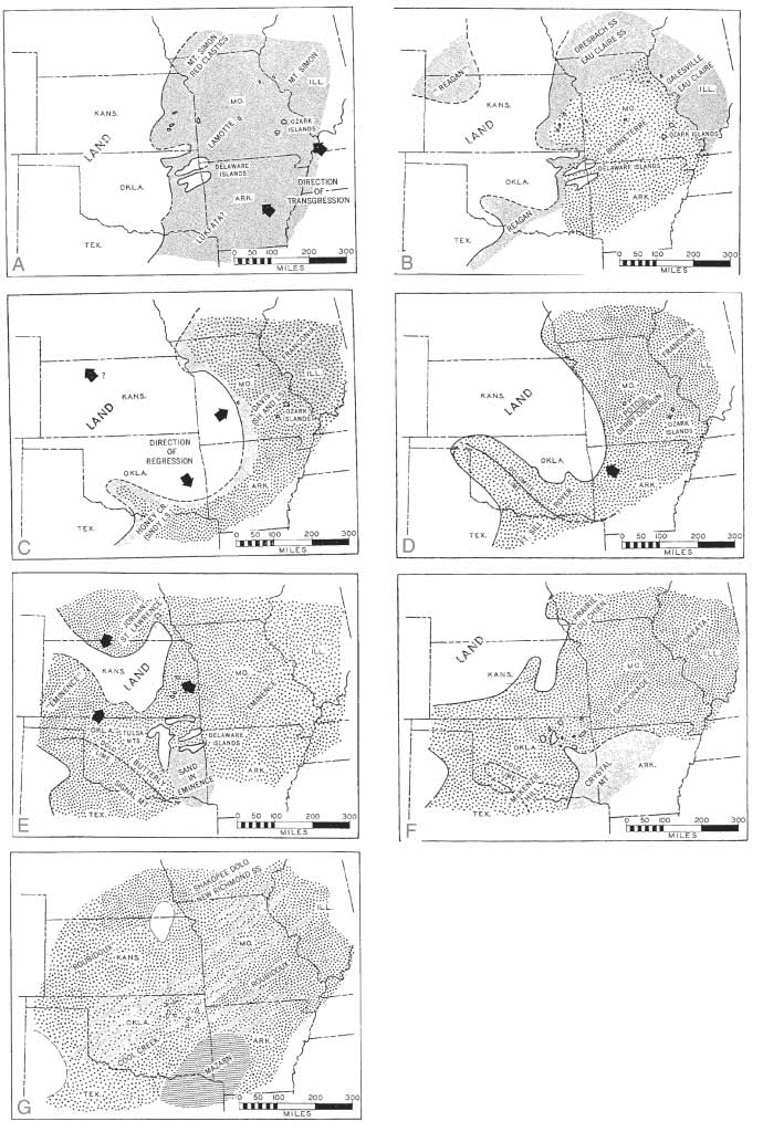
Unconformities identified within the Arbuckle Group in Kansas are likely major sequence boundaries that correlate to relative sea-level oscillations as documented for this time by Ross and Ross (1988) (fig. 14). Chenoweth (1968) used overlap relationships of Late Cambrian and Early Ordovician strata with the irregular basement topography in Kansas, Oklahoma, and parts of bordering states to construct paleogeographic maps and to infer depositional histories associated with transgressions and regressions (fig. 15). Chenoweth (1968) acknowledged that in areas containing no Arbuckle strata, it was difficult to determine if the absence was due to non-deposition or erosion.
Figure 14--Coastal onlap curve for Late Cambrian and Ordovician time based on Ross and Ross (1988). Modified from Shelton and Gerken (1995).
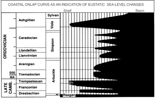
Figure 15--Paleogeographic maps showing distribution of Cambrian-Ordovician units in the midcontinent interpreted to result from transgressions and regressions. A) First stage of the Late Cambrian flooding event. B) Continued transgression and distribution of Bonneterre Dolomite shoreline sandstones. C) Late Cambrian regression left most of Kansas subaerially exposed. D) Subsequent Late Cambrian transgression. Most of Kansas is still a land surface. E) Latest Cambrian paleogeography. Only the highest portions of Kansas remained as a land surface. F) Earliest Ordovician paleogeography. Shorelines in Kansas changed somewhat from Cambrian. G) Kansas experienced almost complete submergence during Roubidoux deposition. From Chenoweth (1968).
Sea level fell near the end of the Early Ordovician. Falling sea level drained the continents and left behind a landscape underlain by predominantly carbonate Cambrian-Ordovician strata and Precambrian basement rocks. Deep weathering and erosion produced a regional unconformity and a regionally extensive karst system over most of the North American craton. This regional system has been called the Arbuckle-Ellenburger-Knox-Prairie du Chien-Beekmantown-St. George karst plain (Kerans, 1988). A vast system of caves, sinkholes, joint-controlled solution features, and collapse breccias developed. These features are found throughout the midcontinent in the Arbuckle, Knox, Beekmantown, Prairie du Chien, St. George, and Ellenburger groups (Gore, 1954; Merriam and Atkinson, 1956; Fisher and Barrett, 1985; Kerans, 1990; Hammes, 1997). However, the nature of the post-Sauk unconformity surface is quite variable (Sloss, 1988). In some areas (such as the Central Kansas uplift) there has been extensive erosion during the post-Sauk regression and numerous additional prolonged periods of subaerial exposure up through the Early Pennsylvanian.
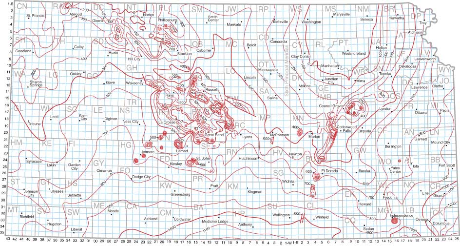
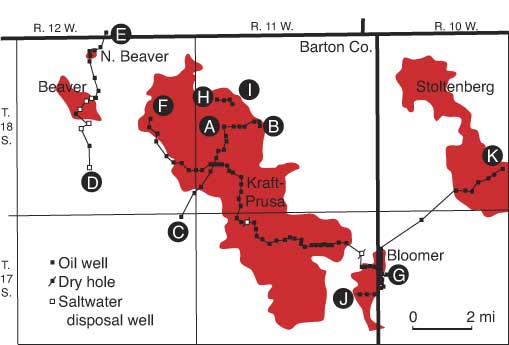
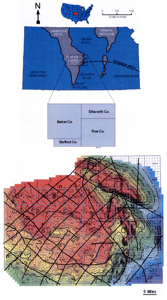
The upper Arbuckle unconformity surface shows a general decrease in elevation to the south (fig. 16), but more complex patterns exist, especially near areas that were structural highs (fig. 17). Many studies over the years have focused on the erosional and karsted nature of the upper Arbuckle surface in Kansas (e.g. Walters, 1946, 1958, 1991; fig. 11). This attention was driven largely by petroleum production in the Arbuckle Group of Kansas, which is associated with the unconformity surface. A recent study by Cansler and Carr (2001) documented karst geomorphology of the upper Arbuckle surface at various scales over the southern part of the Central Kansas uplift in Barton, Ellsworth, Rice, and Stafford counties (fig. 18). They identified major karst landform geometries (dolines, cockpits) and karst erosional features related to ground-water sapping processes.
Figure 16--Regional structure map on top of Arbuckle Group. (A) Central Kansas uplift, (B) Salina basin, (C) Hugoton embayment of the Anadarko basin, (D) Anadarko basin. Contour interval 2,000 ft. From Bartram et al. (1950).
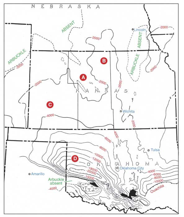
Figure 17--Preliminary regional structural map contoured on top of Arbuckle strata in Kansas. Contour interval 100 ft. From Merriam and Smith (1961).
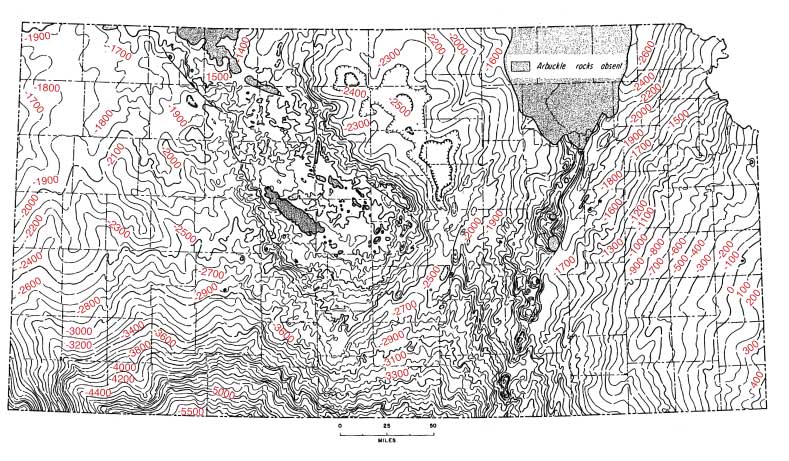
Figure 18--Location map and Arbuckle structure map. Interpreted lineaments from gravity and magnetics maps (dark lines) overlain on the Arbuckle structure map illustrate the general relationship of the erosional surface to basement structural elements. Structural elements in the Arbuckle of the Central Kansas uplift, such as regional uplifts and lineaments, and local uplifts and faults are represented on the Precambrian structure. Basement structure, when recognized, has a significant influence on alignment of karst and drainage features on the Arbuckle erosion surface. Contour interval 20 ft. From Cansler and Carr (2001).
Prev Page--Historical Aspects, Definition || Next Page--Characteristics
Kansas Geological Survey
Web version Dec. 27, 2004
http://www.kgs.ku.edu/Current/2004/franseen/03_dist.html
email:webadmin@kgs.ku.edu