Kansas Geological Survey, Current Research in Earth Sciences, Bulletin 250, part 2
Prev Page--Start || Next Page--Distribution and Geologic Setting
![]()
![]()
![]()
Kansas Geological Survey, Current Research in Earth Sciences, Bulletin 250, part 2
Prev Page--Start ||
Next Page--Distribution and Geologic Setting
![]()
Strata of Late Cambrian and Early Ordovician age that lie between the Precambrian and Simpson rocks in southeastern Oklahoma were named Arbuckle limestone by J. A. Taff in 1902 from exposures in the Arbuckle Mountains (from Lee, 1956). The corresponding sequence in the Ozark region of southern Missouri was termed the "Cambro-Ordovician."
Pre-Pennsylvanian rocks were suspected to exist in the subsurface of Kansas for many years. Their eventual recognition came from wells drilled by the petroleum industry. Biostratigraphic data are lacking and, to date, no chronostratigraphic framework exists for Arbuckle Group subdivisions in Kansas. Therefore, attempts at recognition and correlation of Arbuckle Group subunits through the years relied predominantly on lithologic character and insoluble residues. As the following discussion shows, terminology for the Arbuckle Group in Kansas evolved over many decades and the term, even today, is variably used to include or exclude specific stratigraphic units.
Schrader (1908) first confirmed the presence of pre-Mississippian strata in Kansas from a well drilled near Caney, Kansas. Aurin et al. (1921) used outcrop exposures in northeastern Oklahoma to project correlations of pre-Pennsylvanian rocks in the subsurface of the midcontinent, including Kansas, using well data. They identified a unit, which they termed "Ordovician siliceous limestone," and considered it to be Cambrian-Ordovician in age. Aurin et al. (1921) traced the siliceous limestone into Kansas as far north as Chase County. They noted that the siliceous limestone unit was a thick formation of sandy, cherty, and siliceous limestone that occurred immediately above basement rock in Kansas, except in areas of the Nemaha uplift. Aurin et al. (1921) thought that at least some of this unit was equivalent to the Arbuckle Limestone of the Arbuckle Mountains in southeastern Oklahoma.
In a study of several deep wells in Russell County, on the northern flank of the Central Kansas uplift (CKU), Twenhofel (1927) recognized green shales that contained fossils characteristic of the Decorah shale (Middle Ordovician) and noted several hundred feet of "crystalline limestone" beneath the green shales. Although no fossils were identified, Twenhofel (1927) suggested the limestone strata were early Ordovician or Cambrian in age. It was around this time that wildcatting activity in western-central Kansas increased, which resulted in more abundant data (McClellan, 1930).
Barwick (1928) described the stratigraphy and structure of the Salina basin in north-central Kansas. He recognized a thick pre-Pennsylvanian section in this area and divided it into seven distinct lithologic units. Barwick's Unit 6 consists predominantly of quartz sandstone and lenses of green shale, which he identified as being equivalent to the regionally widespread St. Peter Sandstone. He suggested calling this unit St. Peter in Kansas. The recognition of the St. Peter and its unconformable relationship to the underlying Unit 7 prompted Barwick to conclude that Unit 7 could be correlated with some portion of the Arbuckle Limestone of Oklahoma. Unit 7 was described as a cherty dolomitic limestone, with a few thin streaks of rounded quartz sand, that thinned northward across the state from 900 ft thick in southwestern Butler County to 200 ft thick in Clay County. Barwick also advocated the retention, at least temporarily, of the term "siliceous lime" (presumably after the "siliceous limestone" of Aurin et al., 1921), due to its general usage by geologists.
Edson (1929) built upon previous work and stratigraphic subdivisions of pre-Mississippian strata by incorporating paleontologic and lithologic data from well samples in central Kansas. Her work resulted in several important contributions. Her work marked the beginning of the trend away from usage of the term "siliceous lime." In her first reference to the siliceous lime, she introduced Arbuckle limestone in parentheses and then used Arbuckle limestone in the rest of the paper. She also constructed a correlation chart for Kansas and surrounding states. In her chart, she showed the Arbuckle limestone in Kansas as being Upper Cambrian and Ordovician (Ozarkian-Canadian) in age, equivalent to the Arbuckle limestone in the Arbuckle Mountains of Oklahoma, and equivalent to the Bonneterre Dolomite through Powell Dolomite of Missouri. She also noted that Arbuckle limestone sandy lenses in Kansas generally contained less zircon and tourmaline, more barite, and many more accessory minerals than in sandy zones of dolomite above the St. Peter sand, and she suggested that those characteristics could be used to differentiate the Arbuckle limestone from other pre-Mississippian dolomites in Kansas.
McClellan (1930) constructed maps to show the subsurface distribution of pre-Mississippian strata in Kansas and Oklahoma. He noted that the Arbuckle was present throughout Kansas except in a few small areas. He postulated that the absence was due to non-deposition or to post-Arbuckle, post-Devonian, or post-Mississippian erosion. McClellan indicated that in southeastern Kansas, the Arbuckle limestone was ordinarily about 1,000 ft, on the Barton arch it was less than 300 ft, and on the Nemaha uplift (at El Dorado) it ranged from 365 to 1,100 ft thick. McClellan indicated that the Arbuckle limestone on the Barton arch was mainly white, dolomitic, and characterized by oolitic chert and interbedded coarse sandstone. He used these characteristics in comparison with a similar zone in Oklahoma to suggest that, if the units were correlative, approximately 3,400 ft of upper Arbuckle limestone was missing on the Barton arch. He also suggested that about 4,000 ft of the lower Arbuckle was missing in the area due to overlap on basement paleotopography. In southern and eastern Kansas, McClellan (1930) documented the Arbuckle as fine-grained, locally cherty, brown dolomite, and speculated that it represented the middle of the formation, and thus a lower Canadian or upper Ozarkian age. He also called for the abandonment of the term "siliceous lime." He stated that the term as applied to the Arbuckle was inappropriate and could be misleading because the Arbuckle was only locally siliceous and many other formations, notably the Mississippian, were more siliceous. During the ensuing decade, the term "siliceous lime" eventually was abandoned.
In 1931, McQueen published an important study in which he used detailed insoluble residue data from Cambrian-Ordovician strata in Missouri to subdivide and correlate the different units in that state. This work had a significant influence on subsequent studies and correlation of Cambrian-Ordovician strata in Kansas, especially because most samples available for study were well cuttings and were not sufficient for biostratigraphic study.
Koester (1935), in a study of the CKU, proposed that it was much more reasonable to correlate the "siliceous lime" in Kansas with the Cambrian and Ordovician section in Missouri, instead of the Arbuckle Group of Oklahoma, based on McQueen's (1931) detailed insoluble residue work in Missouri. In working with McQueen and other geologists who had examined samples from Kansas wells, Koester (1935) reported that the data confirmed the presence of the same Cambrian-Ordovician unconformities and certain units that were recognized in Missouri.
Ockerman (1935), in a study of northeastern Kansas, noted that the thick dolomitic limestone series below the St. Peter (the "siliceous lime") also was known as the Arbuckle limestone after the Arbuckle Mountains section, but he preferred using names as proposed in Missouri. He used insoluble residues from samples in Kansas to compare to insoluble residue work from McQueen's (1931) work in Missouri. The result was Okerman's ability to confidently correlate three zones in the "siliceous lime" with the Cotter, Roubidoux, and Bonneterre of the Missouri section. He noted that the Cotter equivalent of the "siliceous lime" is characterized by abundant chert (much of it oolitic), the Roubidoux equivalent is characterized by abundant quartz sand, and the Bonneterre equivalent is characterized by brown and green doloclastic shale. Ockerman (1935) promoted the use of insoluble residues in future work to further improve identification and correlation of pre-Pennsylvanian limestones.
Keroher (1940a, b) in a study of Linn and Montgomery counties asserted that the nearness of Arbuckle exposures in Missouri and the advanced state of classification of those rocks warranted the classification in Missouri to Kansas. These two publications were precursors to a later landmark study (Keroher and Kirby, 1948; discussed below). In his classification chart, Keroher used the Arbuckle Group to include everything from the St. Croixian (Cambrian) to Canadian (Ordovician). The Arbuckle Group was better penetrated in Linn County than in Montgomery County, and so his descriptions from there are used. He described the Lamotte Sandstone (+ 40 ft), unconformably overlying the Precambrian basement, as a coarse sub-round quartz sandstone, the Bonneterre Dolomite (+ 125 ft) as coarsely crystalline gray dolomite containing considerable fine to coarse sand, and the undifferentiated Proctor and Eminence dolomites (150 ft) as light crystalline dolomite. Keroher noted an unconformity at the top of the Cambrian section that is overlain by the Gunter Sandstone, which he described as fine to medium sand at the base. He described the overlying undifferentiated Gasconade and Van Buren dolomites as consisting of 135 ft of light crystalline dolomite containing considerable chert. The Roubidoux Formation consists of 145 ft of gray sandy dolomite and sandstone with angular to rounded sand grains and quartzose chert. The upper part of the Arbuckle Group includes undifferentiated Cotter and Jefferson City dolomites consisting of 168 ft of tan, gray, and buff dense to crystalline dolomite, with chert and large brown oolites.
In a study of the Forest City basin in northeastern Kansas, Lee (1943) continued the use of the term Arbuckle as a convenient term to indicate undifferentiated pre-St. Peter Ordovician and Cambrian strata. He also adopted subdivisions within the Arbuckle recognized in Missouri, but excluded the Cambrian-age Bonneterre Dolomite and Lamotte Sandstone as Arbuckle equivalents. Lee (1943) thought this was a more desirable use of the Arbuckle Group name, being consistent with its usage by Ulrich (1911) in the Arbuckle Mountains.
Walters (1946) worked with Littlefield (unpublished data cited in Walters, 1946) in utilizing insoluble residues for correlation of Cambrian-Ordovician strata in Barton County on the CKU. The criteria used were 1) similarity of detailed sequences of chert types, 2) similarity of sequences of minor clastic zones as shown in insoluble residues, and 3) similarity in sequences of gross lithology factors such as dolomite crystallinity and color. Walters did not focus on detailed stratigraphic subdivision in the paper, but indicated that subdivisions and eventual confident correlation with insoluble residue work in Missouri could be made as more detailed information from wells was available outward from central Kansas towards the outcrops in Missouri.
Keroher and Kirby (1948) published a landmark report on the Upper Cambrian and Lower Ordovician rocks in Kansas. The purpose of their study was to determine the character, thickness, stratigraphic sequence, and distribution of as many zones of the Upper Cambrian and Lower Ordovician rocks in Kansas as possible. In addition to subsurface studies in Kansas, they utilized outcrops in Missouri, South Dakota, and the Front Range of the Rocky Mountains to aid in their identifications and correlations. Following along the same line as previous studies, they incorporated samples and insoluble residues from outcrops and wells drilled in Missouri to help in the identification and correlation of various stratigraphic units from Missouri into Kansas. The resultant product was lithostratigraphic correlation of larger subdivisions across the entire state. Although Keroher and Kirby (1948) advocated the use of the Missouri subdivisions for Kansas Arbuckle strata, they also recognized that the name "Arbuckle" was well established among geologists and others in the petroleum industry. Therefore, upon recommendation of oil geologists in Kansas, Keroher and Kirby (1948) retained "Arbuckle" as a group name for all Paleozoic beds older than the St. Peter Sandstone or Simpson Formation (now Simpson Group) in Kansas, and adopted subdivisions of the Missouri classification. However, they argued against the revised usage of "Arbuckle," as proposed by Lee (1943), and included all Cambrian-age rocks, including the Bonneterre Dolomite and Lamotte Sandstone, in their definition of Arbuckle.
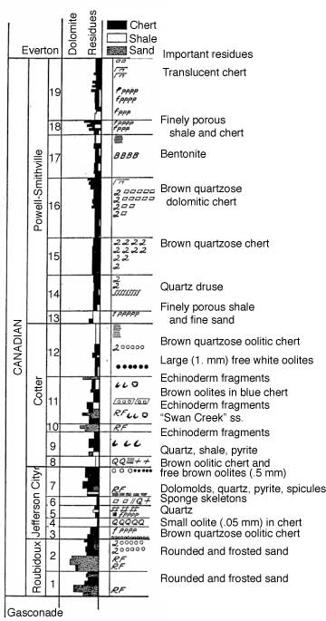
The following is a synopsis of characteristics, descriptions, and correlations of subdivisions made by Keroher and Kirby (1948). Keroher and Kirby (1948) produced cross sections (fig. 1) showing correlations of Arbuckle units across various parts of the state, and thickness maps of the Arbuckle units (fig. 2). Keroher and Kirby (1948) give a thickness range of 1,000-1,200 ft for the Arbuckle in southeastern Kansas with a thinning northward to approximately 500 ft, near Kansas City with continued thinning across the Nebraska state line. In south-central Kansas, the Arbuckle is approximately 900 ft thick with an abrupt thinning to less than 300 ft in north-central Kansas (Ottawa County). They describe an average thickness of 600 ft for the west-central portion of the state, but note thickness varies considerably in the CKU area because of local structural conditions. Arbuckle strata are locally absent in this area. They were not able to determine Arbuckle thickness in southwestern Kansas due to lack of samples, but speculated that the Arbuckle may increase in thickness considerably in that direction. Arbuckle strata are within 500 ft of the surface in the southeastern portion of the state and the depth to the top increases westward to more than 6,000 ft below the present surface.
Figure 1--Diagrammatic cross sections of Cambrian-Ordovician (Arbuckle Group) strata across Kansas. From Keroher and Kirby (1948).
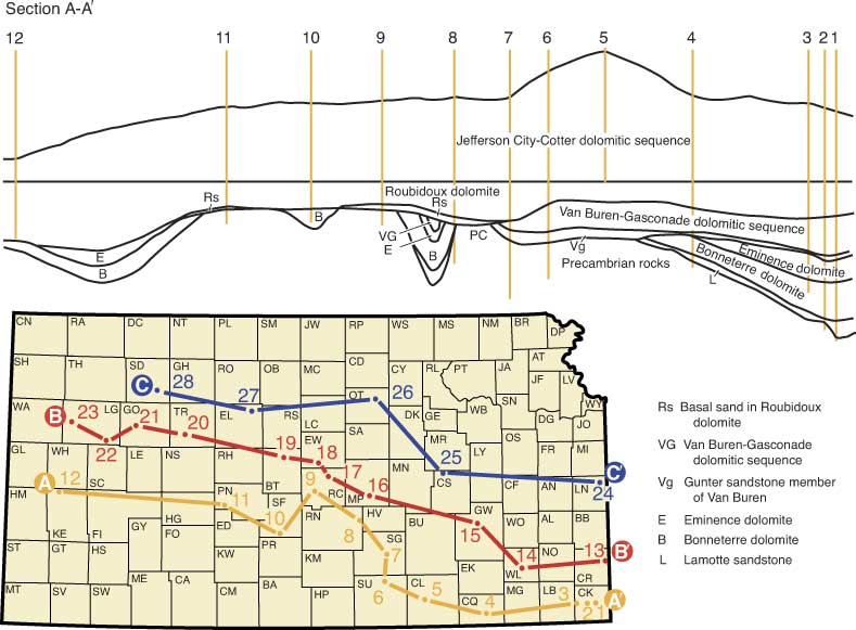
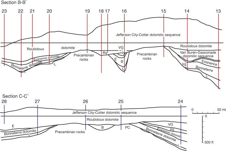
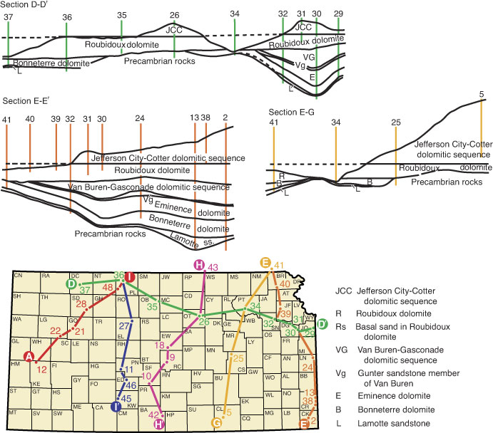
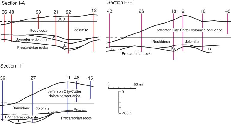
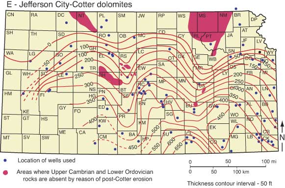
Figure 2--Thickness maps of Cambrian-Ordovician (Arbuckle Group) units in Kansas. A) Bonneterre dolomite. B) Eminence dolomite. C) Van Buren-Gasconade dolomites. D) Roubidoux dolomite. E) Jefferson City-Cotter dolomites. From Keroher and Kirby (1948).
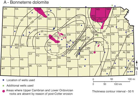
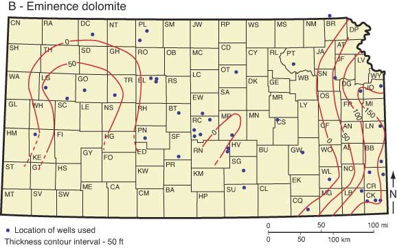
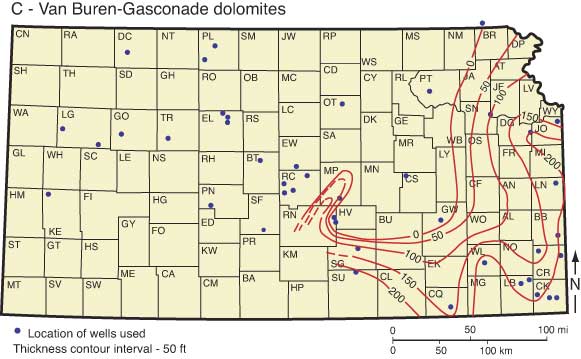
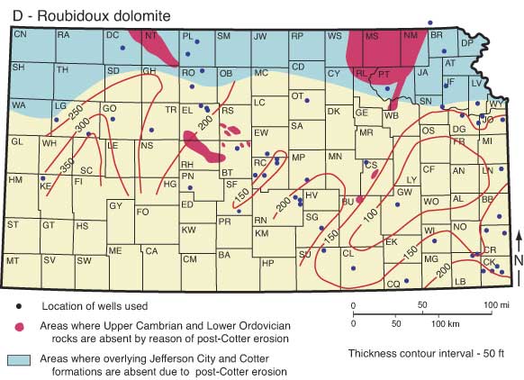
Keroher and Kirby (1948) described the Lamotte Sandstone (ranging from 0 to 130 ft thick) as unconformably overlying the Precambrian basement and occurring in eastern and western Kansas where overlain by the Bonneterre Dolomite. The Lamotte Sandstone is a coarse, subangular to rounded, arkosic sand becoming finer in the upper part and grading into the overlying Bonneterre Dolomite. The Bonneterre Dolomite (0-189 ft) is widespread in eastern and western Kansas and absent in central Kansas. It is described as coarsely crystalline to dense, fine-grained, glauconitic dolomite, locally brown in color and containing fine, silty sand, which is coarser near the Lamotte Sandstone. Green doloclastic shale is common in the upper part. The Eminence Dolomite (0-175 ft) unconformably overlies the Bonneterre Dolomite and only occurs in limited areas in eastern and western Kansas. It is described as a gray to white, coarsely crystalline dolomite containing vitreous and quartzose chert. Green shale and pyrite are common in the lower part. Doloclastic chert occurs in western Kansas. The Gunter Sandstone Member (0-45 ft) of the undifferentiated Gasconade Dolomite and Van Buren Formation (now referred to just the Gasconade Dolomite) unconformably overlie the Eminence Dolomite. It consists of dolomitic sandstone, with polished and rounded quartz grains. The rest of the undifferentiated Gasconade Dolomite and Van Buren Formation (0-233 ft) occurs only in eastern Kansas and rests on the Precambrian basement in south-central Kansas. It consists of light-gray, coarsely crystalline dolomite containing much white, dense, and blue, translucent chert. The Roubidoux Dolomite (0-350 ft) unconformably overlies and is the most widely distributed Lower Ordovician unit in Kansas. It consists of white, very coarsely crystalline dolomite containing abundant fine, bright, angular sand. The undifferentiated Cotter Dolomite and Jefferson City Dolomite (0-667 feet) unconformably overlies the Roubidoux Dolomite and is widespread in Kansas, only being absent in northern Kansas. This unit is characterized by a great variety of cherts and dolomites, and brown oolites. Intercalated sand lenses are common.
Moore et al. (1951) recognized the need for a published rock column for Kansas that summarized the knowledge of the sequence of strata for that time. They defined the Arbuckle Group to include the Cotter Dolomite and Jefferson City Dolomite, Roubidoux Formation, Gasconade Dolomite, Van Buren formation, and Eminence Dolomite.
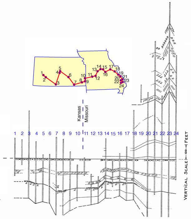
McCracken (1955) continued the theme of insoluble residues for correlation of upper Arbuckle strata from Missouri across southern Kansas (fig. 3). He divided Lower Ordovician (Canadian) strata into 19 subdivisions based on type of residue assemblages, their percentages, pattern of sedimentary cycles, and repetition of occurrences. The 19 zones were defined based on their recognition throughout the state of Missouri. McCracken then recognized that some of the zones could be identified in various areas of the midcontinent region, noting that zones 1-12 (Roubidoux, Jefferson City, Cotter) could be correlated in Kansas, but that zones 13-19 were likely not preserved in any of the Kansas Arbuckle section.
Figure 3--Correlations of Arbuckle Group strata between Missouri and Kansas using insoluble residue zones. From McCracken (1955).
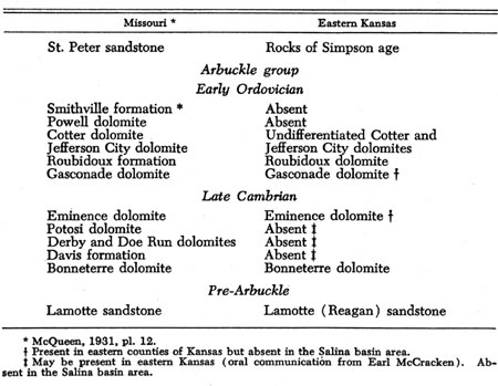
Lee (1956) further utilized the results of McCracken (1955) in a study of the stratigraphy and structure of the Salina basin area. He acknowledged that the original Arbuckle limestone of Oklahoma and the corresponding Cambrian-Ordovician rocks of Missouri had been subdivided into mappable formations, but thought it was still convenient to regard them collectively as the Arbuckle Group. Lee noted that the Bonneterre through Smithville formations were currently regarded as formations included in the Arbuckle Group. Lee (1956) stated that correlation of formations between Missouri and Kansas (fig. 4) was complicated because some formations wedge out toward the west and facies changes made some of the criteria used by McCracken (1955) in Missouri difficult to use in some parts of Kansas.
Figure 4--Relationship between Missouri and Kansas of the formations considered to be Arbuckle Group by Lee (1956).
Walters (1958) indicated that Arbuckle beds in central Kansas, having a thickness of 550 ft, including 300 ft at the top of tan and brown dolomites with oolitic cherts, were the probable correlatives of the Cotter, Jefferson City, and Roubidoux of Missouri. Underlying was 120 ft of white, coarsely crystalline dolomite with low insoluble residue content and 40 ft of sandy dolomite, both of probable Ordovician age. The lowest unit, resting on the Precambrian and thought to be Upper Cambrian, was 110 ft of clean recrystallized sand with no glauconite. This unit was thought to be the likely equivalent to the Lamotte or Reagan sandstone. Walters (1958) did not include the sandstone in the Arbuckle in a stratigraphic sense but included it in isopach-map construction citing the common oil-field practice of a loosely termed "Arbuckle Group."
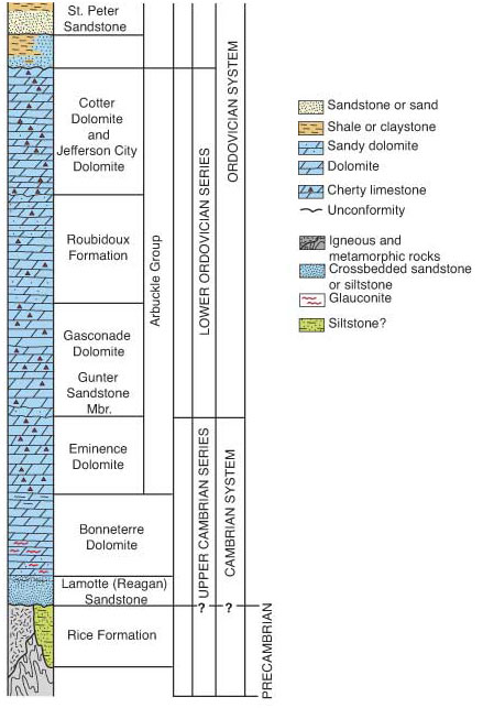
By the 1960's the distribution of the various units of Cambrian-Ordovician strata in Kansas was well documented. However, usage of the term "Arbuckle Group" would continue to vary from author to author. Some included the units between the Simpson Group and Reagan or Lamotte Sandstone, whereas others excluded the Bonneterre or both the Bonneterre and Eminence from the Arbuckle Group (Merriam, 1963; Zeller, 1968). The last accepted published stratigraphic chart of Kansas (Zeller, 1968) included the Eminence Dolomite through the undifferentiated Cotter Dolomite and Jefferson City Dolomite in the Arbuckle Group (fig. 5). Goebel (in Zeller, 1968) revised the Van Buren-Gasconade unit designated by Keroher and Kirby (1948) to just the Gasconade Dolomite, citing the difficulty in separating these units in the subsurface of Kansas, and the abandonment of the term Van Buren by the Missouri Geological Survey.
Figure 5--A portion of the stratigraphic chart from Zeller (1968) showing Arbuckle Group units.
Despite the Arbuckle being subdivided into separate units and defined confidently in places (e.g. Zeller, 1968), the Arbuckle term continued to be variably used. This is exemplified by Cole (1975) who produced isopach maps of Ordovician-Cambrian rocks in Kansas, including the Arbuckle Group, from thousands of well data compiled from wells drilled up to 1965. Although acknowledging the work that had subdivided the Arbuckle, Cole (1975) noted the difficulty of mapping the units in the subsurface, and therefore lumped all Upper Cambrian-Lower Ordovician strata below the Simpson (and including the Lamotte and Reagan sandstones, and the Bonneterre formation) into his Arbuckle Group.
The Arbuckle Group is part of the Sauk Sequence of Sloss (1963, 1988). The basal contact of the Arbuckle Group in Kansas is an unconformity on Precambrian rocks (sub-Sauk surface of Sloss, 1963, 1988) or Cambrian strata (Zeller, 1968; Cole, 1975). As throughout much of the craton of North America, the upper contact of the Arbuckle Group in Kansas is a major unconformity. This unconformity has traditionally been thought to represent the sub-Tippecanoe unconformity at the top of the Sauk Sequence (Sloss, 1963, 1988). However, other workers suggest the upper boundary of the Sauk Sequence is better placed in the Middle Ordovician (Whiterockian) (Derby, Bauer, et al., 1991). In either case, the upper contact of the Arbuckle Group in Kansas is a significant unconformity. Middle Ordovician Simpson sandstone and shale typically unconformably overlie the Arbuckle in Kansas, although Viola Shale or Mississippian strata locally directly overlie Arbuckle rocks. In areas of greatest post-Ordovician uplift, such as the Central Kansas uplift, the Arbuckle Group may be unconformably overlain by beds as young as Pennsylvanian (Merriam, 1963; Cole, 1975).
In 1998, the Lexicon of Geologic Names of Kansas (through 1995) was published by the Kansas Geological Survey (Baars and Maples, 1998). That publication showed the Arbuckle Group to include the Cotter Dolomite, Jefferson City Dolomite, Roubidoux Formation, and the Gasconade Dolomite (including the Gunter Sandstone Member). None of the Upper Cambrian units was included. The 1998 Lexicon defers to the last-accepted published stratigraphic guide for the state (Zeller, 1968) in the case of contention with stratigraphic terms. Therefore, descriptions from Zeller (1968), which included the Eminence Dolomite in the Arbuckle Group, are considered as current and are repeated below.
Eminence Dolomite: Cherty, buff to white, very coarsely crystalline dolomite makes up the Eminence. Vitreous semitranslucent chert contains cavities encrusted by finely crystalline quartz. The chert commonly is mixed so intimately with the dolomite that insoluble residues consist dominantly of chert with lacelike, interconnecting molds of dolomite crystals. An angular unconformity separates the Eminence from the Bonneterre. Occurrence of Eminence deposits in eastern Kansas is confined mostly to a belt three counties wide bordering Missouri. It is recognized also in parts of western Kansas. The formation thickens eastward from 0 to more than 150 ft at the Missouri state line. Thicknesses of 40 to 90 ft are reported in west-central Kansas.
Gasconade Dolomite: Consists mainly of cherty, coarsely granular dolomite. The chert in the upper part, which is dense and gray to dark-bluish-gray, grades downward into white, dense, quartzose chert. The Gasconade is unconformable on Eminence beds and probably also on Bonneterre, Lamotte, and Precambrian beds. Gasconade rocks are reported in the subsurface in a belt along the Missouri state line. The thickness ranges from 0 to more than 200 ft in southeastern Kansas.
Gunter Sandstone Member: This member, present at the base of the Gasconade, is a sandy dolomite.
Roubidoux Formation: In Kansas, this formation consists mainly of sandy dolomite and fine-grained sandstone. Deposition of the Roubidoux seems to have been preceded by folding and erosion of older rocks. Thickness of the formation generally ranges from 150 to 200 ft.
Jefferson City Dolomite and Cotter Dolomite: Because the Cotter Dolomite and Jefferson City Dolomite recognized in outcrops are not distinctly separable in the subsurface on lithologic criteria, they are treated as a unit. They consist mainly of coarsely granular, cherty dolomite. The upper part of the sequence includes much oolitic chert, which becomes white and decreases in volume toward the base where white, tripolitic chert becomes abundant. These rocks unconformably underlie different formations, such as the St. Peter Sandstone on the flank of the Southeast Nebraska arch, the Chattanooga Shale on the Chautauqua arch, and Pennsylvanian rocks on parts of the Central Kansas uplift and Nemaha anticline. The Jefferson City Dolomite probably is conformable on the Roubidoux Formation. The Cotter-Jefferson City sequence ranges in thickness from 0 ft in northern Kansas to more than 650 ft in Cowley County in southern Kansas.
Prev Page--Start || Next Page--Distribution and Geologic Setting
Kansas Geological Survey
Web version Dec. 27, 2004
http://www.kgs.ku.edu/Current/2004/franseen/02_hist.html
email:webadmin@kgs.ku.edu