


Kansas Geological Survey, Public Information Circular (PIC) 2
Salt Contamination of Ground Water in South Central Kansas
Robert W. Buddemeier,
Geohydrology Section, Kansas Geological Survey
Robert S. Sawin,
Geology Extension, Kansas Geological Survey
Donald O. Whittemore and David P. Young,
Geohydrology Section, Kansas Geological Survey
Introduction
The natural contamination of fresh ground water by saltwater is an
important water-quality issue in many areas of Kansas. This saltwater
comes from naturally occurring salt minerals in the subsurface. Proper
management of ground water reduces, and frequently avoids, intrusion of
saltwater into freshwater supplies. This circular provides water users
and public officials with a basic explanation of how saltwater enters
water supplies, and outlines methods that might diminish or prevent natural
salt contamination of freshwater aquifers. South-central Kansas, the
focus of this publication, contains unconsolidated (uncemented) sand and
gravel aquifers of the Great Bend Prairie, the Equus Beds, and the Arkansas
River valley. Many of the same explanations and methods apply in other
parts of Kansas where natural salt contamination is a problem.
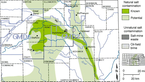
Areas of south-central Kansas where salt contamination of freshwater aquifers
might occur are illustrated in fig. 1. South-central Kansas is shown in detail
because of the high occurrence of salt-contamination problems in this region.
"Natural" sources of saltwater contamination of freshwater aquifers are the
focus of this circular. Locations of "unnatural" salt contamination also have
been included in fig. 1.
Figure 1--Areas with known or potential saltwater contamination
in south-central Kansas. Areas identified as "known" natural salt contamination
have saltwater within the freshwater aquifer. In the areas labeled "potential"
natural salt contamination, subsurface bedrock formations containing salt or
saltwater are in contact with the overlying freshwater aquifers. Groundwater
Management District boundaries (GMD) 2 and 5 are shown in blue.

Kansas Geological Survey, Geology Extension
Web version Nov. 1995
http://www.kgs.ku.edu/Publications/pic2/pic2_1.html