Petroleum: a primer for Kansas, Page 10 of 15
Prev Page--Petroleum geology of Kansas ||
Next Page--Mineral rights and leasing
For example, in north-central Kansas, there is an anomaly known as the Midcontinent Gravity High where the Earth's gravity is about 0.006% greater than normal. In other words, it would be slightly more difficult for a track and field athlete to high jump or pole vault in north-central Kansas than in other parts of the state.
Gravity measurements are made with an instrument known as a gravity meter, and maps can be produced that show differences in the pull of gravity across the state. These variations are useful in locating geologic faults and ancient volcanoes, for example. They can also indicate the presence of geologic basins that are filled with unusually large thicknesses of sedimentary rocks.
These variations in magnetism have been measured for the state of Kansas by towing an instrument known as a magnetometer behind an airplane. The resulting magnetic maps are useful in finding geologic faults and geologic basins that are filled with unusually large thicknesses of sedimentary rocks or buried mountains that arc covered with unusually thin sediments.
Seismic-reflection techniques depend on the existence of distinct and abrupt seismic-velocity and/or mass-density changes in the subsurface. These changes in either density or velocity are known as acoustical contrasts. The measure of acoustical contrast (formally known as acoustic impedance) is the product of mass density and the speed of seismic waves traveling within a material. In many cases, the acoustical contrasts occur at boundaries between geologic layers or formations, although manmade boundaries such as tunnels and mines also represent contrasts.
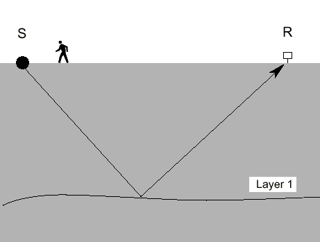
The simplest case of seismic reflection is shown in fig 16. A source of seismic waves emits energy into the ground, commonly by explosion, truck-mounted vibrators, mass drop, or projectile impact. Energy is radiated spherically away from the source. One ray path originating at the source will pass energy to the subsurface layer and return an echo to the receiver at the surface first In the case of a single flat-lying layer and a flat topographic surface, the path of least time will be from a reflecting point midway between the source and the receiver with the angle of incidence on the reflecting layer equal to the angle of reflection from the reflecting layer.
Figure 16--Reflection from one layer.
In the real world, several layers beneath the Earth's surface are usually within reach of the seismic-reflection technique. Fig. 17 illustrates that concept. Note that echoes from the various layers arrive at the geophone at different times. The deeper the layer, the longer it takes for the echo to arrive at the geophone. Because several layers often contribute echoes to seismograms, the seismic data become more complex.
Figure 17--Reflection from three layers.
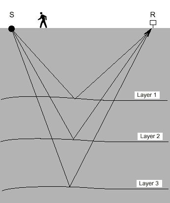
Figure 18--Schematic drawing of seismic-ray paths for a single shot with a six-channel reflection seismograph.
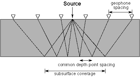
Figure 19--The concept of the Common Depth Point (CDP). Note that ray paths from two different shots (S1 and S2) reflect from a common point in the subsurface.
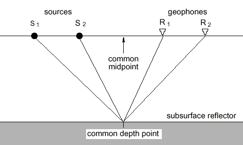
Figure 20--Schematic showing a seismic section relating to real-world geology.
To detect small geologic features, it is necessary to use a seismograph that can record and enhance high-frequency sound waves. The use of high-frequency seismic waves in reflection seismology is known as "high-resolution" seismic exploration. As research and instrumentation developments allow recording higher and higher seismic frequencies, it is becoming possible to prospect for progressively smaller geologic targets.
Compressional waves, or P-waves, are the most common type of seismic wave used for reflection prospecting. P-waves propagating through the Earth behave similarly to sound waves propagating in air. P-waves generate echoes (reflections) when they come in contact with an acoustical contrast in the air or under the ground. In the underground environment, however, the situation is more complex because energy that comes in contact with a solid acoustical interface can be transmitted across the interface or converted into refractions and/or shear waves as well as reflected waves.
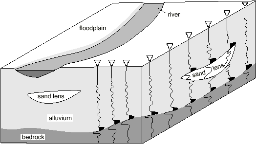
Seismic reflection is sensitive to the physical properties of Earth materials and is relatively insensitive to chemical makeup of both Earth materials and their contained fluids. The seismic-reflection technique involves no assumptions about layering or seismic velocity. However, no seismic energy will be reflected back for analysis unless acoustic impedance contrasts are present within the depth range of the equipment and procedures used. This is identical to the observation that sound waves in air do not echo back to an observer unless the sound wave hits something solid that causes an echo. The classic use of seismic reflections involves identifying the boundaries of layered geologic nits. It is important to note that the technique can also be used to search for anomalies such as isolated sand or clay lenses and cavities.
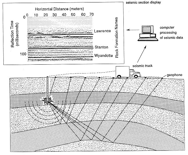
Fig. 21 depicts a single explosive charge fired in a drilled hole to provide a source of seismic waves for a seismic-reflection survey. The seismic waves (which are really sound waves) echo from underground rock layers. These echoes are then detected at the Earth's surface by geophones (which are really low-frequency microphones). The signals are transmitted to the recording truck via cables. The seismograph in the recording truck is much like a multi-channel stereo music system. The seismograph's amplifiers condition and amplify the data and send the data to a digital tape recorder. After the data are placed on computer tape by the recorder, they are ready for processing. The signals are processed in a computer to produce a final display called a seismic section. The seismic section displayed here shows echoes from rock units a few hundred feet below the Earth's surface (the Lawrence, Stanton, and Wyandotte formations).
Figure 21--Schematic cross section of geology, seismic-ray paths, and processed seismic data.
Prev Page--Petroleum geology of Kansas || Next Page--Mineral rights and leasing