Coffey County Geologic Map
A new geologic map of Coffey County is available from the Kansas Geological
Survey. The full-color map, showing the type and age of rocks at the surface,
was developed by retired Survey geologist Daniel Merriam. The map is drawn
at a scale of 1:50,000 (one inch on the map equals about 3/4 mile of actual
distance) and measures about 42 by 38 inches.
The cost of the Coffey County Geologic Map is $15.00, plus $5.00 for postage and handling. See below for ordering information.
High Plains Atlas
A new atlas of maps, depicting the water situation across western Kansas,
was recently published by the Kansas Geological Survey. An Atlas of
the Kansas High Plains Aquifer was edited by Survey water specialists
Jeffrey Schloss and Robert Buddemeier and by Blake Wilson of the Kansas
Water Office. The atlas focuses on the High Plains aquifer, the underground
water-bearing rock formation that underlies much of western and central
Kansas. It consists of 23 full-color maps.
Copies of the book are available for $15.00, plus $4.00 postage and handling.
Current Research in Earth Sciences
Two more articles have been published in the Survey’s online research
bulletin, Current Research in Earth Sciences. The first, “Revisions
to the Nomenclature for Kansas Aquifers,” by Survey water specialist
P. Allen Macfarlane, revised the names of Kansas aquifers based on recommendations
developed by the U.S. Geological Survey. The second article, “The
Relationship Between Geology and Landslide Hazards of Atchison, Kansas,
and Vicinity,” by Survey geologist Gregory C. Ohlmacher, summarizes
recent and older landslides in the area and points out the connections
between landslides and surficial geology. These two articles, along with
previously published articles in the Current Research in Earth Sciences,
can be viewed at www.kgs.ku.edu/Current.
Copies of the above publications are available from the Kansas Geological Survey, 1930 Constant Ave., Lawrence, KS 66047 (785-864-3965), or by e-mail (pubsales@kgs.ku.edu). Kansas residents should add 6.9% sales tax.
New
Publications
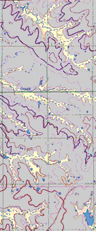
Segment of Coffey County Geologic Map.
During
the Cretaceous Period, about 65 million years ago, dinosaurs roamed the
North American continent. This winter, they will roam the halls of the
Sternberg Museum of Natural History in Hays, Kansas. A special exhibition
featuring a full-scale replica of “Sue,” the largest, most
complete, and best preserved Tyrannosaurus rex skeleton ever
discovered, will explore both the science and the controversy surrounding
this fossil.
The centerpiece of the exhibition is a life-sized
cast skeleton of Sue. Interactive anatomical models will allow visitors
to control the movements of a T. rex’s jaw, tail, neck,
and forelimbs. Visitors can put together a large format, three-dimensional
puzzle of Sue’s skeleton, see the Cretaceous world through Sue’s
eyes, experience an eye-level view of Sue’s skull, and touch models
of Sue’s 12-inch long teeth. Other dinosaur-related events and displays
are scheduled.
The exhibition runs from February 25, 2001, through
April 29, 2001. Admission to the museum will be restricted to a limited
number of people each day during this special exhibit. For tickets and
more information, contact the Sternberg Museum at 785-628-4286 or online
at www.fhsu.edu/sternberg.
Dinosaur Exhibit Travels to Sternberg Museum

URL:http://www.kgs.ku.edu/Publications/GeoRecord/2001/vol7.1/Page3.html