Winter 2000
Vol. 6.1
| |
||
| Kansas Geological Survey | Winter 2000 |
Vol. 6.1 |
|
Survey Researchers Find Rare Volcanic Features
CONTENTS Kimberlites in Kansas–page 1 |
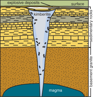
With
rare exceptions, the rocks we see at the surface in Kansas are sedimentary
in origin—that is, they’re made up of particles deposited
by wind or water. Among the exceptions are the kimberlites of Riley and
Marshall counties, igneous rocks formed from the cooling of molten magma
that exploded to the surface during the Cretaceous Period, about 90 million
years ago. Kimberlite is a soft, dull-gray rock with thin white veins that originates
deep in the earth, in the upper mantle—the layer that lies about
25 to 250 miles beneath the earth’s surface. As kimberlitic magma
erupts, it expands, breaking up rock in its path and exploding through
the crust (perhaps at speeds of 1,300 feet per second). These eruptions
form deep, carrot-shaped pipes that often occur in small clusters. The
explosion produces small craters at the surface and leaves behind a mixture
of igneous and sedimentary rock that often contains garnets, a dark-red,
semi-precious stone. In Kansas ten kimberlite pipes, all located in Riley County, have long
been known to geologists. During the summer and fall of 1999, researchers
at the Kansas Geological Survey located and drilled into three new kimberlites,
two in Riley and one in Marshall County. All of the newly discovered kimberlite
pipes are covered with soil, 15 to 20 feet below the ground surface. All
are on private property. Kimberlites are scientifically important because they provide clues about
the deep subsurface: snapshots of an otherwise inaccessible part of the
earth. They also generate economic interest because they are the source
of most of the world’s diamonds. Diamonds form in the upper mantle,
generally at depths between 90 and 125 miles. Kimberlites serve as elevators
that bring diamonds to the surface. However, of the 4,000 kimberlites
known worldwide, 90% do not contain diamonds. So far, diamonds have not
been found in Kansas kimberlites. To find the kimberlites, Survey researchers Tom Weis and Kevin Dobbs conducted detailed surveys of the earth’s magnetic levels. Because kimberlites are composed of igneous rocks, which contain minerals that are different from the surrounding sedimentary rocks, they produce a distinctive magnetic signature. Weis and Dobbs conducted their ground surveys at locations where previous
aerial surveys had indicated possible kimberlites. These aerial surveys
were conducted by Cominco American, Inc., a mining company headquartered
in Spokane, Washington, that explored for diamonds in the early 1980’s.
As a result of their detailed ground surveys, Weis and Dobbs identified
three locations that were likely to have kimberlites below the surface.
Starting in late September 1999, the Survey drilled at these locations
and confirmed the presence of three new kimberlites. At each location, the Survey drilled 300 feet into the kimberlites and
obtained continuous core samples of this rock that originated deep within
the earth. Researchers then performed tests to measure the amount of magnetite,
a mineral inherent in magma, present in the cores from each site. Two
of the cores had fairly consistent readings, suggesting a similarity in
rock characteristics throughout the 300 feet of sample, according to Survey
geologist Pieter Berendsen. But the Marshall County core showed a surprising
variation in the amount of magnetite present. “These huge variations
relate to differences in rock characteristics,” said Berendsen,
“and could indicate that the kimberlite at this site erupted in
a series of different pulses.” Research on the kimberlites is part of a larger Survey study of the geology of the Manhattan quadrangle, a roughly 7,200-square-mile area in north-central Kansas. That study involves mapping the area’s bedrock geology, analyzing the deep subsurface, and looking at geologic hazards such as landslides. |
|
Generalized diagram of a kimberlite pipe. |
 |
|
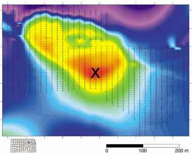
Image showing the results of magnetic surveys conducted last fall at one of the kimberlite locations in Riley County. The red area in the center indicates the strongest magnetic readings. An "x" marks the drill site. The yellow area roughly outlines the boundaries of the kimberlite. |
 |
|
Online February 10, 2003 Comments to: lbrosius@kgs.ku.edu Kansas Geological Survey URL:http://www.kgs.ku.edu/Publications/GeoRecord/2000/vol6.1/Page1.html |