A Place to Visit
Lake Scott State Park
![]()
Scott County,
Kansas
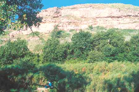
Like an oasis in the desert, the Lake Scott area stands out from the typical High Plains landscape of western Kansas. Situated in a valley carved into the steep bluffs of the Ogallala Formation, the 100-acre lake is surrounded by trees, canyons, and natural springs. The Ogallala bluffs, composed of cemented sands and gravels, are underlain by the Niobrara Chalk. Big Spring (represented by the lush vegetation in the foreground of this photo) and other springs in the area flow from this contact between the Ogallala and the Niobrara. In addition to providing fishing, swimming, camping, boating, and wildlife observation opportunities, Lake Scott State Park and Wildlife Area is rich in history. Near the west edge of the lake is El Cuartelejo, the northernmost pueblo in the United States, built by a group of Taos Indians fleeing Spanish rule in the 1600's. To reach Lake Scott, drive 10 miles north of Scott City on U.S. Highway 83, then turn west on Kansas Highway 95. Travel in a northerly direction about three miles to Big Spring, and another mile to Lake Scott.

Kansas Geological Survey
1930 Constant Avenue, Campus West
Lawrence, Kansas
66047-3726
(785) 864-3965
-
Tom Collinson, Chair, Pittsburg
-
Robert Crangle, Lincoln
-
Dyan Jones, Prairie Village
-
Sheila Leiker-Page, Victoria
-
Jeffrey Mason, Goodland
-
Dennis McKinney, Greensburg
-
Stephen Morris, Hugoton
-
Larry J. Richardson, Wichita
-
John K. Strickler, Manhattan
-
William W. Hambleton, Emeritus Member, Lawrence
-
A. Scott Ritchie, KU Geology Assoc. Rep., Wichita
Director: Lee Allison
The mission of the Kansas Geological Survey, operated by the University of Kansas in connection with its research and service program, is to conduct geological studies and research and to collect, correlate, preserve, and disseminate information leading to a better understanding of the geology of Kansas, with special emphasis on natural resources of economic value, water quality and quantity, and geologic hazards.
The Geology Extension program furthers the mission of the KGS by developing materials, projects, and services that communicate information about the geology of Kansas, the state's earth resources, and the products of the Kansas Geological Survey to the people of the state
Online February 10, 2003
Comments to: lbrosius@kgs.ku.edu
Kansas Geological Survey
URL:http://www.kgs.ku.edu/Publications/GeoRecord/1999/vol5.3/Page4.html