Winter 1998
Vol. 4.1
| |
||
| Kansas Geological Survey | Winter 1998 |
Vol. 4.1 |
|
KGS Study Provides Information on Kansas River
CONTENTS River Corridor Study–page 1
|
The
Kansas River and its floodplain are the major sources of sand and gravel
in northeastern Kansas. A report titled The Kansas River Corridor—Its
Geologic Setting, Land Use, Economic Geology, and Hydrology was recently
published by the Kansas Geological Survey. A summary of this report was
included as an attachment in a multi-agency recreation study submitted
to the legislature on January 12, 1998. Controversy over expansion of sand dredging in the Kansas River prompted
the 1996 Legislature to order a study of the river’s recreational
opportunities. This study was conducted by five state agencies—the
Kansas Department of Commerce and Housing, Kansas Water Office, Kansas
Geological Survey, Kansas Biological Survey, and Kansas Department of
Wildlife and Parks. Survey geologist Larry Brady represented the KGS on the multi-agency
task force. “The Survey’s role in the recreation study,”
Brady said, “was to provide additional information on the river
in general, with emphasis on sand and gravel production.” As its title suggests, the Survey report provides a range of geological
and hydrological information about the Kansas River and its corridor.
The corridor is the area six miles on either side of the Kansas River
from its headwaters at the confluence of the Smoky Hill and Republican
rivers in Junction City to its junction with the Missouri River in Kansas
City. The Kansas River corridor supplies most of the sand and gravel for the
10 Kansas counties bordering the river. About 40 percent of the state’s
population live in these 10 counties; by 2025, population projections
suggest half the state’s population will be concentrated in these
counties. In 1996, dredges on the Kansas River produced about 2.4 million tons
of sand and gravel worth about $8 million, which generated nearly $357,000
in sand royalties to the State. The river dredges produce some of the
best quality and least expensive sand in the United States. Sand and gravel
is also obtained by pit dredging in the floodplain. Currently, dredging
operations in the Kansas River corridor include nine river dredges and
seven pit dredges. In general, the broad floodplain, thin overburden, and lower land prices
make pit dredging more viable along the upper part of the river (Junction
City to Topeka). On the lower part of the river (Topeka to Kansas City),
the floodplain narrows, the overburden is greater, and land prices are
higher, leading producers to favor in-river dredging. A recent study of
the river floodplain (KGS Open-file Report 97-66) identified 74 potentially
profitable pit-dredging locations, 49 of which are in Pottawatomie, Wabaunsee,
and Shawnee counties. A byproduct of glaciers that once covered the northeastern part of the
state, the Kansas River probably began 600,000 years ago as an ice-margin
stream that carried meltwater and sediments eastward along the edge of
the glacier into the Missouri River. Since then, the course of the river
has changed many times. Today it meanders 170 miles through its 138-mile-long
river valley, and its basin, the area drained by the river and its tributaries,
extends 500 miles westward from Kansas City to just northwest of Limon,
Colorado, covering an area larger than the state of Iowa. One of the recommendations from the multi-agency recreation study was that a portion, or portions, of the Kansas River be set aside exclusively for recreational use. “Both recreation and dredging can coexist on the river. We don’t want to pit one against the other,” Brady said. “We just want the decisions about recreational and commercial uses of the river to be based on all the available information.” |
|
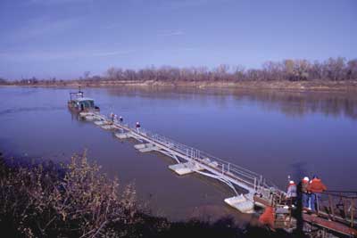
River dredge on the Kansas River near Topeka, Kansas. |
 |
| Online February 10, 2002 Comments to: lbrosius@kgs.ku.edu Kansas Geological Survey URL:http://www.kgs.ku.edu/Publications/GeoRecord/1998/vol4.1/Page1.html |