Spring 1996
Vol. 2.2
| |
||
| Kansas Geological Survey | Spring 1996 |
Vol. 2.2 |
| Reviving the Arkansas River
CONTENTS Arkansas River–page 1
|
Drive
over the Arkansas River bridge on the south edge of Dodge City, and you’ll
see a river bed filled with tumbleweeds and sand maybe marked by tire
tracks and foot prints. What you won’t see, unless you’re
real lucky, is water. Most Kansans know that the state recently won a decade-long legal battle
with Colorado over the amount of water that Colorado takes from the river.
But reviving the Ark won’t be as simple as just adding water. The
quality of water in the river is equally important. Don Whittemore, geohydrologist
at the Kansas Geological Survey, is analyzing variations in the quality
of Ark River water. When the Arkansas leaves the Rocky Mountains in Colorado, its water is
clear and clean. By the time it enters Kansas, the water is slightly salty.
That’s been true since the late 1800’s, shortly after ditches
were built to divert water from the river for irrigation. The water that
moved over the fields and back into the river (known as return flow) was
slightly salty, because evaporation concentrated the salt. When large
reservoirs were built on the Arkansas in Colorado in the mid-1900’s,
evaporation increased and salinity got worse. Today, even in dry times, small amounts of water are released into the
river from Colorado’s John Martin Reservoir and from return flows
in eastern Colorado. This maintains streamflow as far west as Syracuse,
in Hamilton County. Between Syracuse and Garden City, around the town
of Lakin, the river disappears (it begins to flow on the surface again
near Great Bend). The Ark dries up after Lakin because some water is drained
away by local irrigation ditches. The rest seeps out of the river channel
and into adjacent beds of sand and gravel, called the High Plains aquifer.
Ground-water pumping, mostly for irrigation, has lowered water tables
in the aquifer, causing the slightly salty water to move from the river
into the aquifer. The salinity problems also occur in wetter times. In July 1995, snow-melt
in the Rockies and heavy rains caused the Ark to flow all the way through
western Kansas. Whittemore found that the water was fresher than it was
during dry times, but still slightly salty from Coolidge to Dodge. Again,
that slightly saline water moved out of the river and into the aquifer.
“Saline water is contaminating the Ark River valley,” says
Whittemore. Salinity may not stop the use of that water for irrigation—“slightly saline water is better than no water,” says Whittemore—but it may be salty enough to cause problems for other uses. At Garden City, for example, high-quality ground water is necessary for manufacturing, for meat packing, and for domestic and industrial uses. In addition to analyzing river water, Whittemore has compiled historical
measurements of the river’s water quality and checked water from
neighboring wells. “We need to document where the saline water is,
how fast it’s moving, and what kind of steps you can take to ameliorate
the salinity,” says Whittemore. To help do that, Whittemore is planning
more water sampling of the river and neighboring wells and is developing
computer models of the water’s movement. He also plans to drill
test wells that will tell more about the local geology. In the meantime, any additional releases of water from Colorado may help
dilute the salinity. “With proper management, these new releases
should be less saline,” says Whittemore. “But they won’t
be completely fresh, and we’ll still have the problem.” Whittemore’s research is funded by the Kansas Water Plan and is
done in cooperation with the Kansas Water Office, Division of Water Resources
and Division of Plant Health of the Kansas Dept. of Agriculture, Groundwater
Management District #3, the Kansas Dept. of Health and Environment, and
the Southwest Kansas Local Environmental Planning Group. |
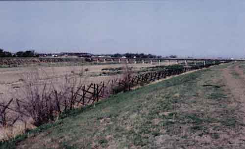
| The Arkansas River
channel, on the south edge of Dodge City in May 1996. Photo by Robert
Sawin. |
 |
| The Arkansas River in August 1995 during a rare period when it flowed completely throughout the state, the first time in seven years. Here water is diverted from the river into the Amazon Ditch in western Kearny County, one of several irrigation canals built in western Kansas in the 1880’s. Photo by Don Whittemore. | 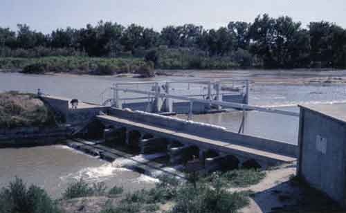 |
| Online February 10, 2003 Comments to: lbrosius@kgs.ku.edu Kansas Geological Survey URL:http://www.kgs.ku.edu/Publications/GeoRecord/1996/vol2.2/Page1.html |