Spring 1995
Vol. 1.1
| |
||
| Kansas Geological Survey | Spring 1995 |
Vol. 1.1 |
| Photos Document Grand Canyon Changes Since Historic 1923 Expedition
CONTENTS Grand Canyon–page 1 |
The
Colorado River has been carving the Grand Canyon for at least 30 million
years. In the last seven decades, the river hasn’t changed the canyon
much, but human activity has. The Canyon Revisited—A Rephotography
of the Grand Canyon, 1923–1991 features 45 pairs of black-and-white
photographs of the Grand Canyon—one set taken in 1923, the second
in 1991 by Survey photographer John Charlton from the same locations.
Survey staff members Don Baars and Rex Buchanan wrote the text. The 1923 photographs were shot during an expedition sponsored by the
U.S. Geological Survey, aimed at mapping the canyon and examining possible
dam sites. The geologist on that trip, Raymond C. Moore, was the state
geologist of Kansas, and his photographs and field notes reside today
in the University of Kansas archives. In September 1991, a group of 16 people spent three weeks in the canyon,
pinpointing the sites of the 1923 photos. The 1991 crew, funded privately
by Franklin Gaines of Hamilton, Kansas, took new photographs, then compared
old with the new. “The purpose of rephotography is to compare a
set of old photos with new ones to determine what changes have occurred,”
said Don Baars, author of a number of books on the geology of the Colorado
Plateau. “The 1923 trip was probably the most important trip down
the Colorado River since John Wesley Powell’s 1867 expedition. The
1923 crew saw the canyon before the advent of human changes that began
with the construction of Hoover Dam in the 1930’s and Glen Canyon
Dam in the 1960’s.” Some photo pairs show little change in the canyon over 68 years. Except for rapids, where flooding has rearranged boulders, many geologic features appear much the same—most canyon walls show little erosion and the same rocks can be recognized in old and new photos. Other photos, however, show substantial change, much of it related to
human activity. Probably the most noticeable change is the explosive growth
of new vegetation. The Glen Canyon Dam has restricted flooding, allowing
vegetation to take hold along the river’s edge. Non-native plants,
like the tamarisk or salt cedar, have invaded the river bank in huge numbers.
The Canyon Revisited—A Rephotography of the Grand Canyon, 1923–1991 (University of Utah Press, 1994) is available from the Kansas Geological Survey for $19.95 plus shipping and tax for Kansas residents. |
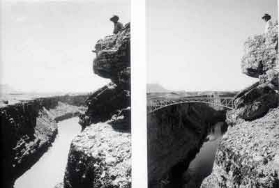
| Marble Canyon and
Navajo Bridge. Left photo is on R. C. Moore, 1923, from USGS archives.
Right photo is of T. McClain, taken in 1991 by J. Charlton. |
 |
| Online February 10, 2003 Comments to: lbrosius@kgs.ku.edu Kansas Geological Survey URL:http://www.kgs.ku.edu/Publications/GeoRecord/1995/vol1.1/Page1.html |