![]()
Prev Page--Introduction || Next Page--Petrography
Geology
Kansas volcanic ash deposits described in this report are all of Pliocene and Pleistocene age. They occur as lenticular bodies within the mass of alluvial sediments that comprise the Pliocene Ogallala formation and the Pleistocene (late Kansan) Meade formation. All deposits examined show distinct bedding and in some places the individual beds are less than 1 mm thick. Intricate cross bedding in thin zones is common, and ripple marks, rain drop impressions, and imprints of plant leaves have been observed. Nowhere in Kansas has typical eolian cross bedding been observed in the volcanic ash. In some of the Pleistocene deposits, snail shells have been found abundantly at the base of the ash, sparsely scattered throughout the deposit, and in the beds immediately above the ash (Leonard, 1950). Many of these shells are from aquatic animals that lived in ponded water, and at a few localities the percentage of land forms decreases toward the center of the ash lentil. Many of the larger Pleistocene deposits are underlain by a massive gray to light-tan clay and the margins of the lentil suggest that the ash accumulated in a depression. These evidences show conclusively that the ash observed in most localities found its final point of deposition in a permanent or intermittent shallow body of water even though it is clear that the ash shards were carried by winds from a volcanic source somewhere west of Kansas.
Volcanic dust was thrown explosively into the air somewhere in the Rocky Mountain belt, perhaps in north-central New Mexico (Swineford, 1949), and was carried by winds over Kansas and adjacent areas. The ash shards settled to the ground, or were carried down by rains, resulting in a thin layer of fine-textured ash spread extensively over the surface. This thin surface layer of readily available material served to overload rills and minor streamlets leading into ponds or undrained depressions that existed on the extensive plain of alluviation in early Pliocene time and in Pleistocene time other ponds on aggrading valley flats and even rarely in upland situations. These small tributaries were able to carry material which was predominantly ash into the depressions until they had cleared at least a part of their drainage areas. Such a mode of accumulation accounts for the sharp lenticularity and range in thickness of the deposits, and for the varying degrees of contamination by nonvolcanic grains of silt and sand sizes and also for the apparently random geographic variation in the particle size of the ash itself. It also makes the job of prospecting or exploring for new deposits an extremely difficult one for although the exact stratigraphic positions of the several ash beds in their respective formations may be determined, the presence of a usable deposit at any particular locality is largely fortuitous. On the other hand the determination of the proper stratigraphic position of the beds serves to eliminate much impossible territory and therefore is an invaluable aid in exploration. For that reason the stratigraphy of Kansas volcanic ash will be reviewed briefly.
Pliocene Deposits
In Kansas, beds of Pliocene age are classed as belonging to the Ogallala formation which contains in ascending order the Valentine, Ash Hollow, and Kimball members (Moore and others, 1951). The Ogallala formation consists almost exclusively of alluvial sediments ranging in texture from silty clay to coarse gravels. Uneven loose to firm cementation by calcium carbonate occurs at random throughout the section and has given rise to the local name "mortar beds." In the Valentine and lowermost Ash Hollow members siliceous cement is common (Frye and Swineford, 1946). Nearly all the Ogallala sediments are lenticular in occurrence and for that reason it is extremely difficult to establish any stratigraphic horizon precisely within the formation; in fact at many places it is impossible to establish the member boundaries within tens of feet. Approximate stratigraphic placement within the Ogallala can be made by use of fossil vertebrates and fossil seeds. Diagnostic fossil vertebrates are known from relatively few places and the field geologist is commonly forced to rely on the floral zones described by Elias (1942). The extent and usability of these floral zones in Kansas have recently been discussed (Frye and Leonard, 1949; Moore and others, 1951, p. 18), and they, together with gross stratigraphic position, have been used to determine the placement within the Ogallala of the volcanic ash beds. The generalized stratigraphy of the Ogallala formation in Kansas and tentative placement of the several ash beds is shown in the graphic section in Figure 2.
Figure 2--Idealized composite stratigraphic column of the Ogallala formation in Kansas showing the tentative stratigraphic placement of Calvert, Reager, and unnamed volcanic ash beds.
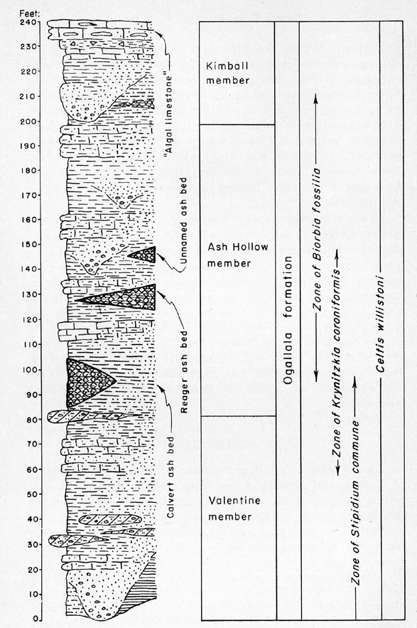
Four petrographically distinctive volcanic ash beds have been recognized within the Ogallala formation of the Great Plains region (Swineford and Frye, 1946; Frye, Swineford, and Leonard, 1948) and disseminated shards occur at many stratigraphic positions within the clastic sediments. Of these four, one is known from localities in northwestern Texas (Hemphill County) and possibly also from western Oklahoma. In Kansas the Hemphill, Texas, ash has not been identified with certainty although one exposure of weathered ash in Hamilton County, Kansas, possesses some characteristics in common with it. Three petrographically distinctive ash beds occur in the Ogallala of Kansas; the deposits occur primarily in the northwestern part of the State. One of these beds, studied from three exposures in Norton County, is here named the Calvert ash bed, from the pit of the Wyandotte Chemicals Corp. at that northeastern Norton County town. Another bed has been studied from nine localities in Wallace, Decatur, Norton, Rawlins, and Phillips Counties and is named the Reager ash bed from exposures 1 mile north of the stop on the Burlington Railroad in west-central Norton County. The third bed, so far unnamed, is known from two exposures in Phillips County.
Available stratigraphic data place all three of these beds in the lower half of the Ash Hollow member. The Calvert bed occurs low within the member and the Reager bed is significantly higher stratigraphically, perhaps near the midpoint. The unnamed bed is judged on the basis of meager evidence to be at least as high in the section as the Reager bed, and one exposure of weathered and petrographically indeterminate Ogallala ash in central Norton County may be even higher as abundant fossil seeds of Biorbia fossilia (Berry) were collected 20 feet below its base.
Although evidence from fossil floras is imprecise it nevertheless furnishes a guide to stratigraphic placement. At the type locality of the Calvert bed (Pl. 1A) fossil seeds have been collected from the upper part of the ash and identified by Dr. M. K. Elias as Krynitzkia coroniformis Elias, Stipidium variegatum var. dartoni Elias, and Celtis willistoni (Cockerell). Fossil seeds of Biorbia fossilia (Berry) and Berryochloa amphoralis have been collected as much as 100 feet higher in the local section but not adjacent to this bed. This floral assemblage suggests a position low within the Ash Hollow or within the underlying Valentine member. It is considered to be above the Valentine, however, as Stipidium commune Elias, characteristic of the Valentine member in Norton County, has not been found adjacent to it, and as subsurface data (Frye and Leonard, 1949) show this bed to be locally as much as 100 feet above the base of the formation.
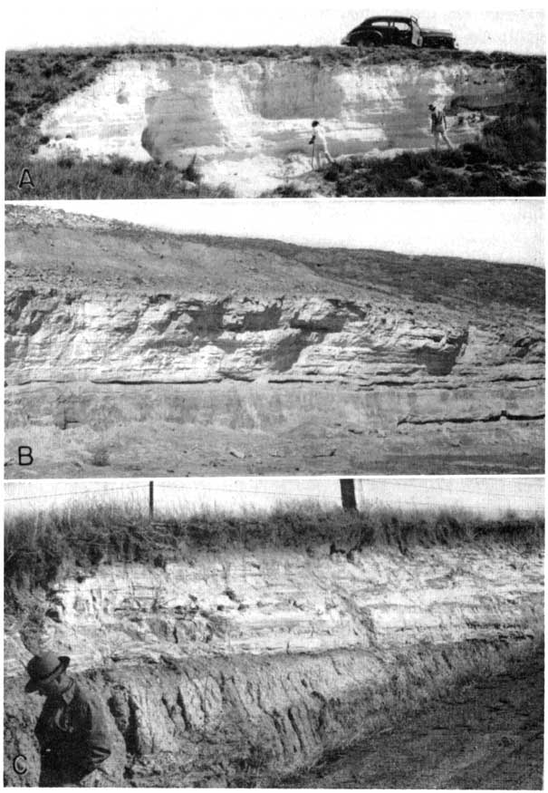
Plate 1--Pliocene volcanic ash in Norton County. A, Mine of Wyandotte Chemicals Corporation at Calvert; Calvert bed, 22 feet thick at this locality. B, Exposure of Ogallala formation showing Reager ash bed, type locality, NW NE sec. 36, T. 2 S., R. 25 W. Biorbia fossilia (Berry) occurs in beds above volcanic ash. C, Cemented upper part of volcanic ash, Reager bed, south of Almena. Fossil seeds both above and below ash bed (Frye, 1945).
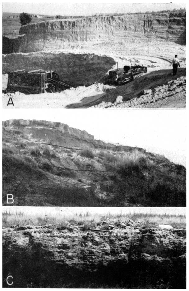
The Reager bed at its type locality (Pl. 1B) is immediately overlain by sediments that have yielded Biorbia fossilia (Berry) seeds and is shown by test hole data (Frye and Leonard, 1949) to be approximately 200 feet above the local base of the formation. Two other localities, correlated on the basis of petrographic similarities with the Reager, furnish usable data as to the placement of the bed. South of Almena in Norton County this ash (Pl. 1C) is exposed in a section where 163 feet of Ogallala has been measured and an adjacent test hole indicates the existence of at least 75 feet of Ogallala below the base of the exposed section. At this locality the Reager ash is 82.4 feet below the top of the local section, below beds yielding abundant Biorbio fossilia and immediately above beds yielding Krynitzkia coroniformis. This locality is less than 5 miles from the Calvert type pit and relative topographic situations suggest that the Reager bed may be about 50 feet higher in the section than the Calvert bed. In Wallace County the Reager bed occurs 76 feet below the top of the Kimball member of the Ogallala but only 6 feet above the base of the local section (Elias, 1931, p. 157).
The stratigraphy of the unnamed Ogallala bed in Phillips County has not been studied in detail. It occurs in a topographic situation that suggests a placement in the section as high or higher than the Reager bed.
Pleistocene Deposits
The stratigraphy of the Pleistocene volcanic ash is relatively simple. All commercially usable ash of Pleistocene age known to occur in Kansas is assignable to the Pearlette bed (Pls. 2, 3) which occurs within the Sappa member of the Meade formation (Moore and others, 1951, p. 14). This ash bed is distributed throughout much of the State (Fig. 1). Samples of ash from 90 localities in 34 counties have been determined to belong to the Pearlette bed. Its placement within the Pleistocene section of the State is shown in the graphic section in Figure 3. The name Pearlette was proposed for this bed by Cragin in 1896, and recently its petrographic character, stratigraphy, and associated molluscan fauna have been described in detail (Swineford and Frye, 1946; Frye, Swineford, and Leonard, 1948; Leonard, 1950). It is associated at many places with a distinctive molluscan fauna, and at a few localities fossil vertebrates have been collected just below its base. Its presence in sediments deposited during latest Kansan time along the then existing drainage ways makes exploration for new deposits a less difficult job once the Pleistocene geology of the region is understood.
Figure 3--Idealized composite stratigraphic column of the Pleistocene desposits in western Kansas showing the position of the Pearlette volcanic ash bed.
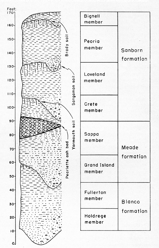
Plate 2--Pearlette volcanic ash in Meade, Logan, Trego, and Grant Counties. A, Pit operated by Mic-Co Products Company, NE sec. 26, T. 32 S., R. 28 W., Meade County; 18 feet of ash exposed (Frye, 1940). B, Pit in SE NE sec. 11, T. 13 S., R. 35 W., Logan County. Maximum thickness of ash, 9 feet (Plummer, 1948). C, Exposure along creek bank, NW, SE sec. 28, T. 14 S., R. 21 W., Trego County. Maximum thickness, 7.5 feet (Plummer, 1948). D, Pit in SE NE sec. 1, T. 30 S., R. 36 W., Grant County, 19.5 feet of ash exposed (Plummer, 1948).
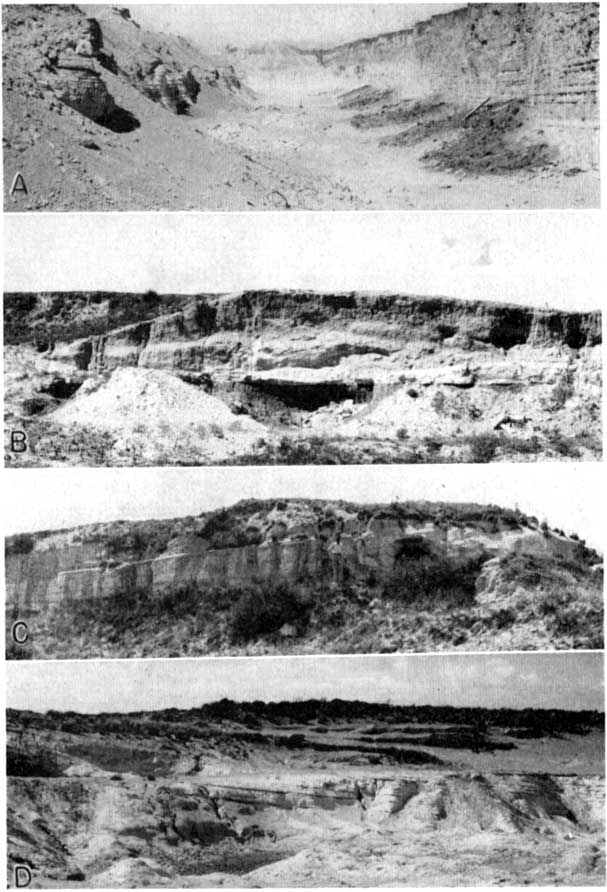
Plate 3--Pearlette volcanic ash in Gove, Sheridan, and Lincoln Counties. A, Pit in the NE SW sec. 21, T. 13 S., R. 26 W., Gove County; 11 feet of clean ash exposed (Plummer, 1948). B, Pit in NW sec. 34, T. 8 S., R. 23 W., Sheridan County. Maximum thickness of ash, 16 feet (Frye, 1951). C, Exposure in road cut, NW, SW sec. 27, T. 13 S., R. 10 W., Lincoln County; 7 feet of ash exposed (Frye, 1951).
The Pearlette ash occurs in lenticular bodies ranging in size from a few yards to more than a mile in extent and from a few inches to approximately 30 feet in maximum thickness. The silt and sand of the Sappa member that contains the Pearlette is commonly relatively thin and constitutes an average overburden of 5 to 20 feet. At some places, however, the Meade formation, which is composed of the Grand Island sand and gravel member below and the Sappa member above, forms the filling of early Pleistocene valleys that have since been abandoned. In such situations the Sappa member may be overlain by various thicknesses of Loveland silt member and Peoria silt member of the Sanborn formation of late Pleistocene age. Overburdens of more than 100 feet are known to occur at places where these younger silts overlie the Sappa. The Peoria loess generally contains disseminated ash shards, but nowhere in Kansas is a deposit of recognizable ash known within this loess.
In the glaciated region of northeastern Kansas a few thin small deposits of Pearlette ash are known to occur in local water-laid sediments unconformably above Kansas glacial till. The Pearlette volcanic ash bed has been identified also in Texas, Oklahoma, Nebraska, Iowa, South Dakota (Frye, Swineford, and Leonard, 1948), Missouri, and Colorado.
Prev Page--Introduction || Next Page--Petrography
Kansas Geological Survey, Kansas Volcanic Ash Resources
Comments to webadmin@kgs.ku.edu
Web version Jan. 2005. Original publication date Feb. 15, 1952.
URL=http://www.kgs.ku.edu/Publications/Bulletins/96/04_geol.html