
|
Original published in D.F. Merriam, ed., 1964, Symposium on cyclic sedimentation: Kansas Geological Survey, Bulletin 169, pp. 381-398 | |
University of Wisconsin, Geological and Natural History Survey, Madison, Wisconsin
Five successive episodes of submergence and emergence of the shelf are indicated in pre-Cincinnatian deposits. Each episode was caused by the interaction between negative tectonic adjustments in geosyncline and basin areas and positive tectonic adjustment in shelf, dome, and arch areas.
Each environment of deposition was located on a shallow marine shelf and was confined to a zone which occupied a position roughly parallel to the ancient shoreline. In an episode of submergence and emergence each environment migrated first shoreward and then seaward over the shelf producing one cycle of sediments. Deposits of the beach-nearshore environment were the first to be laid down over the submerging land surface and are taken as the basal lithotope of a cycle. Maximum retreat of the sea during any regression coincides roughly with the seaward or southerly limit of deposits of this environment. Deposition in other environmental zones during submergence caused the spreading out of their deposits over those of environmental zones located closer to shore. Thus, beginning at the base of a cycle of sediments, deposits which accumulated in shelf environmental zones located successively farther from the shoreline occur one on top of the other. Reverse ordering of lithotopes may occur with emergence.
The paleoslope of the shelf was to the southeast, and south, and transport of sediments was essentially south and southwest roughly parallel to the shoreline.
No satisfactory explanation has been advanced to account for the lithologic relationship of these strata except that they have been considered to be cyclic and to have been deposited during successive transgressions and regressions of the sea over a broad and shallow shelf. With the exception of the quartzarenites and the carbonates, no attention has been focused on the similarities between other repetitive elements in the section nor has much attention been given to the significance of these elements in terms of geologic history.
Some recent investigations (Dapples and others, 1948; Krumbein and others, 1949; Pettijohn, 1957; Pryor, 1960; Wells, 1960) suggest that the vast majority of sedimentary rocks represent repetition or recurring patterns of sedimentation. Pre-Cincinnatian Paleozoic strata of the Upper Mississippi Valley area consist of a series of alternating sandstones and carbonates with subordinate siltstones and shales. This alternation occurs in a broad and regular cyclical pattern spanning the entire sequence. The sequence consists of five regular sets of these alternating strata. Each set consists generally of four lithotopes indicating four depositional environments and is considered to represent a sedimentary cycle. The four lithotopes and their environments of deposition are: (1) quartzarenites deposited in the beach-nearshore environment; (2) poorly sorted generally coarser grained calcareous quartzarenites, transitional with both the overlying and underlying lithotopes, which developed seaward of the beach-nearshore environment in a zone that was subject to variations in energy and sediment supply and to encroachments by neighboring environments of deposition; (3) shales or argillaceous sandstones deposited in the depositional shelf environment; and (4) carbonates deposited in a shelf-reef environment.
The objectives of this paper are to describe the lithotopes, to analyze them in terms of environments of deposition, and to derive from these a broad framework of geologic history which adequately accounts for their pattern of occurrence.
The study is based on examination of approximately 150,000 feet of subsurface well cuttings and numerous ontcrops in Wisconsin and neighboring states. In addition, a large amount of literature dealing with these deposits has been reviewed.
Acknowledgments--This study was undertaken as the initial step in a program designed to re-evaluate the Paleozoic geology of Wisconsin. The author is especially indebted to George F. Hanson, State Geologist, for many discussions of the geology and for editorial assistance.
The author gratefully acknowledges all those investigators whose published works were drawn upon in the preparation of this manuscript. It is not practical to make reference to all of these authors, but where their work is drawn on directly acknowledgment is made.
Thanks are also due to staff members of the state geological surveys of Michigan and Illinois. Discussions with Arthur E. Slaughter and Garland D. Ells of the Michigan Geological Survey Division and with Drs. H. B. Willman, Grover H. Emrich, and T. C. Buschbach of the Illinois State Geological Survey were particularly valuable. Charles Lee Holt, Madison, Wisconsin, and Kenneth E. Vanlier, Lansing, Michigan, members of the Groundwater Branch, U. S. Geological Survey, also contributed to the geological discussions. The suggestions of Professors Lewis M. Cline and Robert H. Dott, Geology Department, University of Winconsin, who read the manuscript, are gratefully acknowledged.
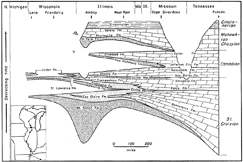
Figure 1--North-south generalized cross section showing relationships of pre-Cincinnatian Paleozoic strata from Lena, Wisconsin, to Pulaski, Tennessee. Vertical scale is much exaggerated and is intended to show relative thickness, inferring a general time relationship. Section is approximately 1200 miles long. Prepared from sample studies of Wisconsin wells and from published logs from Illinois (Workman and Bell, 1948), Missouri (Grohskopf, 1955), and Tennessee (by Freeman, in Dolt and Murray, 1954). A larger version of this figure is available.
Deposits of this lithotope are essentially monomineralic consisting of rounded quartz sand grains with minor amounts of other constituents (total usually less than 5 percent). Impurities are rare and consist generally of noncarbonate materials. The heavy mineral suite is restricted and is dominated by zircon, tourmaline, ilmenite, and leucoxene. Garnet and anatase are minor constituents although garnet is abundant locally.
The texture of the quartzarenites is mediumand fine-grained although locally coarse sand grains and granules are abundant. Clay, silt, and very fine sand are notably rare or absent.
The homogeneous mineralogical and textural character of this lithotope render it indivisible on a regional scale and only partially so on a local scale. Locally a conglomerate may occur in its base as, for example, is the case with the St. Peter and Mt. Simon Sandstones in Wisconsin.
The quartzarenite lithotopes show a general thinning, and are laterally transitional with carbonate deposits, in the direction of the Appalachian geosyncline to the southeast. Areas of thickest sand accumulation coincide with intracratonic basins.Textural and mineralogical characteristics of the sandstones do not change significantly with changes in thickness. Bedding is medium to massive, but may be thin locally.
Directional indicators such as cross-bedding and ripple marks show that sediment was transported from north and northeast to south and southwest, a direction, as will be seen later, that corresponds with the strike of the paleoslope and with the trend of the ancient shorelines.
Fossils are exceedingly rare in the quartzarenites and, where found, consist of small fragments of shells or trails or burrows. Where fragments have been indentified, the forms are generally identified with, or closely related to, those which occur in underlying strata.
Contact of the quartzarenite lithotope with underlying strata may be sharp or transitional. Where sharp it may or may not be considered unconformable. Each of the sandstones is known from at least one outcrop to be unconformable with underlying strata. Examples of unconformable contacts occur at the base of Mt. Simon Sandstone as well as at the bases of the Jordan and St. Peter Sandstones as can be seen from the cross section of Figure 2. Contacts at the bases of the Galesville and New Richmond Sandstones are not so well known. Lee indicates unconformities beneath both of these sandstones in the Ozark area (1943, Fig. 3). Quick (1959) studied a series of cores collected near Troy Grove, in northern Illinois, and concluded that the basal contact of the Galesville is disconformable. Examination of exposures of the Chapel Rock Formation in the Northern Peninsula of Michigan, equated by Hamblin (1958, 1961) with the Dresbach Group of Wisconsin, and considered here to be the lithologic equivalent to the Galesville Formation of Wisconsin, indicates an erosion surface at its base overlain by 15 feet of conglomerate. The New Richmond Sandstone is suspected of being unconformable with the underlying Oneota Formation in the vicinity of a quarry exposure located near Eastman, Wisconsin (Andrews, 1955), at Stillwater, Minnesota (Ulrich, 1924), and in the Ozarks (Lee, 1943).
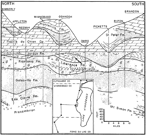
Figure 2--Northeast-southwest cross section of pre-Cincinnatian Paleozoic strata from Kimberly to Brandon in eastern Wisconsin showing variability in thickness and lithology of St. Peter and Jordan Formations. Base of Prairie du Chien Group is used as datum plane. Section covers horizontal distance of approiximately 40 miles. A larger version of this figure is available.
Recent studies of shelf deposition and sediments in the northwest Gulf of Mexico indicate that deposits of the littoral zone, a marginal zone comprising "...the sediments of the beaches, barriers, and nearshore..." shelf area consist of "...almost pure fine and medium grained generally well sorted sands" (van Andel and Curray, 1960, p. 352-53). The width of this zone, in a seaward direction, is shown to attain a maximum of about 10 miles by van Andel (1960). This zone is one of high energy and includes the surf zone and the turbulent zone (Parker, 1960) down to a depth of 6 fathoms off the Texas coast (Shepard and Moore, 1955) and to 10 fathoms around the southwestern part of Trinidad (van Andel and Postma, 1954).
Sediment delivered to the sea by rivers, together with sediment eroded from the shore by the transgressing sea, is winnowed and redistributed by waves and currents. The coarser fraction, consisting of sand, is distributed in the beach-nearshore zone by waves and longshore currents (Johnson, 1956) similar to those in the northwest Gulf of Mexico today (Curray, 1960) which parallel the shoreline. Johnson (1956) reports sand is moved parallel to the shore in the longshore drift system out to depths of from 60 to 80 feet.
The direction of maximum inclination of cross beds is interpreted to indicate the current direction involved in the transport and deposition of ancient sediments (Pettijohn, 1957,1962; McKee, 1957). The predominant direction of sediment transport indicated by cross-bedding in pre-Cincinnatian sandstones deposited in the beach-nearshore zone is to the southwest and south (Potter and Pryor, 1961).
A study of the St. Peter Sandstone and Simpson Group by Dapples (1955) indicates that the St. Peter Sandstone sheet reached its southerly depositional limit along an indefinite northeast trending line through western Kentucky which represents roughly the zero contour of occurrence of deposits of the beach-nearshore zone and is interpreted to indicate approximately the configuration of the shoreline at that time. Directional properties show that sand of the St. Peter was transported in a direction parallel to this as well as to later hypothetical shorelines (Fig. 3). Similarly, the southerly depositional limits of the other quartzarenites, as constructed from the data of Lee (1943), Cohee (1948), Workman and Bell (1949), and Emrich (1962), and from numerous published well records, indicate roughly the shoreline configuration at the time of their initial stages of deposition, and directional properties indicate that sand was transported generally parallel to this shoreline (Fig. 3). Present northerly limits of the quartzarenites are due to erosion and bear no relationship to the extent of original occurrence.
Deposits of the beach-nearshore zone are characteristically thick to massive bedded, cross-bedded, and are composed of clean and sorted sand.
The finer fraction, consisting of fine sand, silt, and clay, is distributed farther out on the shelf by marine dispersing agents. The distance and direction from their source at which these fines are ultimately deposited depends on the distribution pattern of the dispersing agents (Curray, 1960).
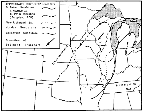
Figure 3--Map indicating approximately southerly limit of occurrence of quartzarenites. Limit is interpreted to indicate approximately shoreline configuration at time of deposition of sands which formed earliest deposits of these formations. Dominant transport directions, as determined from current lineation and crossbedding measurement, are indicated by arrows. Limits of Galesville, New Richmond, and St. Peter Sandstones modified from Workman and Bell (1948), Emrich (1962), Powers (1935), and Dapples (1955). A larger version of this figure is available.
The poorly sorted lithotope consists of coarse-grained quartzarenites which are commonly interbedded with strata composed of materials ranging in size from silt to granules or with arenaceous carbonate strata. The coarse sandstone beds locally contain thin layers of shale and conglomerate. Some beds are very well sorted. Heavy minerals are essentially the same as those which occur in the underlying quartzarenites, although the garnet content may be higher near its base.
Certain beds in some of the units assigned to the poorly sorted lithotope can be traced over broad areas. For example certain beds in the Ironton Formation are cited as being laterally persistent and as maintaining essentially uniform thickness over distances of up to 100 miles in west-central Wisconsin (Emrich, 1962).
The poorly sorted lithotope thickens in intracratonic basin areas; for example, the Ironton Formation shows an increase of from zero feet in south-central Wisconsin to about 100 feet basinward in northeastern Illinois (Emrich, 1962; Buschbach, 1960).
The coarse-grained beds are commonly cross-bedded. The poorly sorted silty beds are massive and may contain abundant burrows. Mixing of these beds is thought to have been accomplished by the same organisms that produced the burrows. Ripple marks are most common in finer grained beds. Conglomerates are of limited lateral extent and are composed of locally derived materials.
Fossils may be common, especially in the upper part. They are most abundant in the finer grained and poorly sorted beds and consist of the burrows already mentioned and of trails, and less commonly of brachiopod shell fragments and casts and molds of trilobites.
Contact with the underlying quartzarenite may be sharp or transitional. The contact is placed at the base of the lowest bed indicating reworking and is generally based on the change upward to coarser grained sandstone that appears to be better sorted in individual beds, and that may contain materials ranging in size from silt to granules. These strata are generally silty and somewhat calcareous, and they may contain ferruginous cement, fossils, glauconite, pyrite, and beds of shale, dolomite, and conglomerate.
The environment of deposition of the poorly sorted lithotope must account for vertical variability between beds and lateral persistence of individual units. Vertical lithologic variability is interpreted to mean unstable and frequently changing environmental conditions. An area of the shelf in which such conditions exist is located seaward from the beach-nearshore zone, as for example in a large part of the central shelf in the northwest Gulf of Mexico, and is called the nondepositional shelf zone by van Andel (1960; van Andel and Curray, 1960). Neighboring environments of deposition encroach into this zone in response to a variety of conditions and form deposits characteristic of their particular environment. The name "nondepositional" shelf zone is of questionable value because sediment actually is deposited here when sediment supply, available energy, and distributing and dispersing agents change in response to rapid shifts in environment. However, the name is used for drawing comparison between Recent and Pre-Cincinnatian deposits.
In contrast to the environment of deposition of the quartzarenite lithotope, considered to be one of consistently higher energy than those located more seaward, the poorly sorted lithotope is erratic and is subject to extremes of energy conditions. At times of low wave and current energy finer materials normally carried to more remote areas may be deposited, bottom conditions stabilize, animals establish themselves, and neighboring environments of lower energy may encroach on the area. At times of high wave energy bottom sediment is churned up, finer materials are kept in suspension or removed, coarse materials are left behind, animals adapted to low-energy conditions are displaced or destroyed, and neighboring environments of lower energy are encroached upon. It is suggested that periodic storm activity was responsible for much of the modification of bottom sediments in this area.
This environment is, thus, seen to expand, contract, and shift position frequently in response to changing energy conditions causing intricate mingling of deposits characteristic of environments on either its landward or seaward sides which encroach into and retreat from the nondepositional zone
The argillaceous lithotope is characterized by fine-grained sediments consisting of shale or silty or argillaceous sandstone. Clay may occur as a green coating on sand grains or it may be present in thin shale partings or in shale beds up to 10 or 12 feet thick; it may also occur in the form of abundant glauconite pellets. Carbonate is common as cementing material or as thin beds. The heavy mineral suite is dominated by garnet (up to 90 percent; Driscoll, 1959) with lesser amounts of ilmenite, leucoxene, tourmaline, and zircon.
This lithotope is uniform in composition on a regional scale. Variations are due chiefly to differences in shale-to-sand ratio and locally in carbonate content.
The argillaceous lithotope thins southward and southeastward in the direction of the Appalachian geosyncline and is transitional with carbonate at its seaward edge. In intracratonic basins it may thicken appreciably as do both the Eau Claire and Franconia Formations (Fig. 1). Locally its thickness does not change significantly.
The argillaceous lithotope is commonly thin bedded or shaly which distinguishes it from the underlying lithotopes in which bedding ranges from massive to thin. Cross-bedding may be well developed and is commonly delicate as befits a fine-grained clastic. Ripple marks and current lineations are locally abundant. Intraformational conglomerates are common and are composed of materials derived locally from subjacent beds. Pebbles and cobbles in the conglomerates are commonly sandstone cemented with carbonate. The matrix of the conglomerates is generally calcareous and contains fine sand, silt, and clay.
Fossils, usually consisting of fragments and bits of brachiopod shells, trilobite molds and casts, and abundant burrows and trails, may be common in the argillaceous lithotope.
Contact of the argillaceous lithotope with the underlying lithotope is generally sharp and even. The surface of contact was leveled by waves that reworked bottom sediments at a time when the area was located in shallower water or at times of storm. Selection of the contact is based on the abrupt change from silty medium- and coarse-grained calcareous sandstone to silty fine- and very fine grained calcareous argillaceous and glauconitic sandstone or to shale.
The environment of deposition of the argillaceous lithotope is the depositional shelf located generally seaward from the area of nondepositional shelf environment (van Andel, 1960). The uniformity of texture, composition, and thickness of this lithotope over broad areas is interpreted to indicate a stable euvironment having an essentially constant energy level and a uniform rate of sediment accumulation. Variations in this uniformity are thought to be due to nearness to neighboring depositional environments or to minor shifts of environmental areas at times of major wave and current activity.
The fine clastics winnowed from the river sediments in the beach-nearshore environment were deposited farther offshore in accordance with the distribution pattern of marine currents. The amount of sediment which accumulated was a function of sediment supply and of local shelf subsidence.
Present-day deposition of fine sediment on the shelf in the northwest Gulf of Mexico is restricted to the area beyond the beach-nearshore zone and occurs primarily in the middle and outer shelf areas. The pattern of dispersion of these sediments appears to be independent of the coarser sand distribution (van Andel, 1960).
The carbonate lithotope is the most readily recognizable of all the lithotopes as it is characterized by carbonate rocks. In the lower part of each carbonate unit sand grains and minor amounts of shale, silt, and glauconite are generally present. Higher in the section these constituents may drop out completely. In other cases beds of shale and sand can be found throughout the unit.
In this lithotope fossils are more diversified than in those of the other three lithotopes. Bedding varies from medium to massive. Biohermal reefs are universally present, but laterally discontinuous, in all carbonates excepting those of the Ottawa Group in which they are rare.
The carbonate lithotope maintains a uniform thickness locally and shows a regional thickening into basin and geosynclinal areas. In the geosynclinal area, carbonate sections appear to be continuous, uninterrupted by intervening beds of sandstone or shale. Exceptions to the local uniformity of thickness occur where erosional unconformity exists between a carbonate and the overlying lithotope or where an irregular reef surface is buried by sediment of a succeeding lithotope.
Where the carbonate is succeeded by a deposit characteristic of a neighboring environment, for example that of the depositional shelf area, the contact is commonly transitional and even. If the carbonate is succeeded by a deposit characteristic of a more remote environment of deposition, for example that of the beach-nearshore area, then the contact is likely to be one of unconformity.
Contact of the carbonate lithotope with the underlying argillaceous lithotope is sharp and even. The regularity of this contact is striking.
The bulk of carbonate deposition today is taking place in reef environments similar to those which occur on the shelf off the east coast of Australia, off the southeast coast of Florida, or in the northwest Gulf of Mexico. Areas of active reef development in the northwest Gulf of Mexico are located in water shallower than 30 fathoms (Parker and Curray, 1955; Stetson, 1953) in the nondepositional shelf zone and in areas of stable but unconsolidated bottom where all other requirements for their development exist. Ladd and Hoffmeister (1936) and Cloud (1952) hold that reefs may develop upward from any stable, but not necessarily solid, pre-existing platform within reach of sea level in areas where all other requirements for their development exist and that they will continue to develop so long as these requirements are not altered. Reefs are not developing in the vicinity of the shoreline in the northwest Gulf of Mexico because nearshore conditions which include unstable bottom and abundant shifting sediment are inhospitable to reef development.
The carbonate lithotopes in Cambrian and Ordovician rocks of the Upper Mississippi Valley are believed to be a geologic manifestation of carbonate depositing environments of the present, namely the shelf-reef environment. The conclusion that these lithotopes probably developed in a reef environment seems logically inescapable (Gilluly, Waters, and Woodford, 1951; Cloud, 1952). Studies of the Oneota Dolomite (Starke, 1949) and of the "Trenton" formations (Du Bois, 1945) in the Upper Mississippi Valley indicate that they were deposited during times of transgression by the sea and that they accumulated in the shelf-reef zone as a series of intermingling carbonate deposits which were spread out as sheetlike bodies shoreward over the shelf by the transgressing sea.
The Shakopee Dolomite in northern Illinois presents a somewhat unique problem to the area in that it consists of interbedded fine-grained dolomite, quartzarenite, shale, and discontinuous thin layers of oolitic chert. Locally the sandstone layers are conglomeratic and contain pebbles and cobbles of dolomite derived from subjacent dolomite layers, otherwise they consist essentially of quartz sand similar to that characteristic of the quartzarenite lithotope. The upper surface of dolomite beds may be ripple marked and cracked. Biohermal reefs also occur at scattered localities. The vertical lithologic variability of the Shakopee indicates changing energy conditions, and the cracks, oolites, and conglomerates signify shallow and agitated waters. The abundance of quartz sand and clay indicates that a source of terrigenous clastics was near.
Deposits having these characteristics are found in shallow-water lagoons. A lagoon receiving, alternately, terrigenous clastics, and carbonate would have to be situated between the mainland at one side and a barrier, for example a reef, at the other. It is postulated that the Shakopee had such an origin.
Lagoonal deposits differ considerably from those of the open shelf, for example banks, which consist almost entirely of carbonate material. Sediment deposited in a lagoon may come from four sources: the mainland, the reef, nonreef skeletal hard parts, and chemical precipitation. The gradation from reef onto lagoonal sediments ranges from sharp to indefinite. In a shoreward direction a barrier reef may pass, with indefinite or complexly interfingering relation, into lime sands that surround small patch reefs and eventually into lagoon lime sands, evaporites, or purely clastic sediments (Cloud, 1952). In the Great Barrier Reef lagoon, terrigenous materials are being distributed by strong currents. According to Fairbridge (1950) a limited amount of calcium carbonate is precipitated from the sea water in lagoons and reef-fIat pools. However, the work of Illings (1954) indicates that much of the sediment accumulating on the Bahama Banks is authigenic and forms by the physicochemical and biochemical extraction of aragonite from warm shallow sea water saturated or super. saturated with calicum carbonate. Thus, much of the carbonate in ancient deposits may be authigenic.
Sedimentation is described as extremely rapid in the Great Barrier Reef lagoon because of the retaining effects of the outer reef barrier (Fairbridge, 1950). The amount of terrigenous and calcareous materials that accumulate in a lagoon varies in respect to supply and nearness to the main land or the reef. In the area of the Great Barrier Reef, terrigenous material commonly exceeds 90 percent near the mainland. In the reef vicinity calcareous clastic materials and chemically precipitated muds may form 98 percent of the total (Fairbridge, 1950).
Such uniformity over so long a time and over such a wide area can reflect only major tectonic control The behavior of basement rocks of the craton provides that control This underlying tectonic control is the immediate cause of persistent paleoslopes, of recycling, and of the location and orientation of major clastic deposits ultimately derived from distant tectonic lands.These authors interpreted the dominant southwestward direction of sediment transport to have been toward the continental margin, parallel to their paleoslope and perpendicular to the shoreline. In the present study direction of sediment transport, especially in the beach-nearshore zone, is interpreted to have been parallel to the shoreline, hence sediment transport was parallel to the continental margin, which lay toward the Appalachian geosyncline to the southeast and south, and perpendicular to the paleoslope, a relationship demonstrated for the St. Peter Sandstone by Dapples (1955).
During the Late Cambrian and Early and Middle Ordovician there existed in the Upper Mississippi Valley high areas referred to as the Wisconsin Dome, the North Huron Dome, a connecting link between these two domes called the Northern Michigan Highland, and the Canadian Shield (Fig. 4). The major intracratonic basin of this time was the Illinois-Michigan Basin. The Ozark area is considered to have subsided in Paleozoic pre-St. Peter time and to have risen before the end of the Cincinnatian (Eardley, 1951; Lee, 1943). Deformation during this interval is believed to have resulted in the development of many arches and other structural features on the craton including the Kankakee Arch, which separated the Michigan Basin from the Illinois Basin (Ekblaw, 1938), and the Findlay and Waverly Arches which bordered these basins along their southeastern margin (Woodward, 1961)
Figure 4--Map of eastern North America indicating areas of pre-Cincinnatian Paleozoic orogenic activity (adapted in part from Eardley, 1951; King, 1959).

In a somewhat irregular pattern seaward from, and roughly parallel with, the coast one can expect to encounter the depositional environments of the beach-nearshore zone, nondepositional shelf zone, depositional shelf zone, and shelf-reef zone (van Andel, 1960; van Andel and Curray, 1960). Migration of each environment over the shelf results in their being deposited in sheetlike bodies over the shelf surface, one on top of the other.
Deposits of the emergent phase are not as well represented as those of the submergent phase. This is especially true of deposits developed in higher energy environments located in the nearshore and inner shelf depositional zones. Regression of the sea exposes these environments and their characteristic deposits to subaerial erosion. Thus, during emergence, deposits of the nearshore-beach environment are continually reworked and removed to the retreating shoreline. For this reason they can be expected to be rare unless they are lowered, by local subsidence, beyond reach of erosion in which case they will be preserved.
A continuous sheet of coalescing nearshore beach sands will be deposited over the erosion surface in the subsequent submergent phase. Deposits of the submergent and emergent phases will be continuous only in the area outlined by the width and breadth of the beach-nearshore environment at the time of maximum emergence wbich is small in comparison to the aerial extent of the quartzarenite. The erosion surface separating deposits of two cycles may be preserved if it is cut in durable material, or is buried beneath sediment before it can be affected by eroding or reworking agents; otherwise it may be obscured by these agents as the sea advances. In either case the quartzarenite lithotope is taken to indicate renewed submergence, the beginning of a new cycle of deposition, and is the basal unit of a cycle of sediments.
The break between lithotopes of different cycles representing continuous deposition in the same shelf environment from one cycle into the next, as for example continuous carbonate deposition from one cycle into the next in seaward areas of the shelf unaffected by sea-level changes, may be difficult if not impossible to detect. A shift in direction of migration of the strandline over the shelf surface in these areas would be obvious only if marked by a lithologic break such as would be produced by the encroachment of a neighboring environmental zone. A shift to submergent conditions would be reflected in the overlying lithotope by re-appearance of deposits indicating more seaward environments of deposition.
Carbonate lithotopes may be modified if a well-developed shelf-reef area is submerged to a depth greater than that required for reef growth at a rate exceeding the capacity of the reef to develop. This results in death of the reef in seaward areas and new reef development in shallower waters located shoreward. Similar changes have occurred in the northwest Gulf of Mexico and are interpreted to be the result of eustatic changes of sea level during the Pleistocene (Ludwick and Walton, 1957), although they might just as easily have been caused by tectonic adjustment.
Subaerial erosion produces an erosional unconformity with high local relief, as at the base of the St. Peter Sandstone, and abrupt changes in thickness of the overlying lithotope and often complete removal of one or more underlying lithotopes. The unconformity may have low local relief but be of wide areal extent resulting in incomplete removal of the underlying lithotope, or lithotopes, over extensive areas, as for example, at the base of the Jordan Sandstone.
Regressive phases are identified in Cambrian cycles but are unknown in Ordovician cycles. It is suggested that active subsidence of the Illinois-Michigan Basin during shelf emergence, at the close of the Mt. Simon and Galesville cycles, caused regressive deposits to be lowered beyond the reach of subsequent erosion and resulted in their preservation. During succeeding cycles shelf emergence apparently was not accompanied by subsidence of the basin.
The Jordan and New Richmond cycles of the Lower Ordovician differ from other cycles in that their shale or argillaceous sandstone lithotopes, representing the depositional shelf environment, are poorly known. Development of the argillaceous lithotope in the Mt. Simon and Galesville cycles is thought to have been caused by regression of the depositional environment into an actively subsiding basin area which received a large amount of fine clastic debris from a large land area of moderate relief. Regression prior to development of the Jordan and New Richmond cycles was less than during previous cycles and did not extend into basin areas; land areas were low and of low relief and provided only small amounts of clastics, and consequently less sediment accumulated in the depositional shelf environment.
Five sedimentary cycles, indicating five successive episodes of shelf submergence and emergence, occur in these rocks. Strata comprising each cycle are indicated in Table 1 and their relationships to each other are shown in Figure 1.
Table 1--Strata comprising each of five pre-Cincinnatian Paleozoic sedimentary cycles in Upper Mississippian Valley are indicated.
| Cycles | Depositional environments | |||
|---|---|---|---|---|
| Beach-nearshore | Nearshore shelf | Depositional shelf | Reef | |
| 5 | St. Peter Fm. | Nokomis Mbr. | Harmony Hill Mbr. | Ottawa Group |
| 4 | New Richmond Fm. | ? | Present, but unnamed | Shakopee Fm. |
| 3 | Jordadn Fm. | Madison Mbr. | Blue Earth Mbr. | Oneota Fm. |
| 2 | Galesville Fm. | Ironton Fm. | Franconia Fm. and Lodi Mbr. |
Black Earth Mbr. (Trempealeau Fm.) |
| 1 | Mt. Simon Fm. | "U. Mt. Simon" | Eau Claire Fm. | Bonneterre Fm. |
Paleozoic sediments were deposited on an erosion surface cut in Precambrian rocks. The basal Paleozoic deposit in this area is the Mt. Simon Sandstone. The Mt. Simon is a quartzarenite which was deposited on a subsiding shelf in the nearshore-beach environment by a transgressing sea as a sheet of prograding and coalescing sand bodies filled in and mantled the erosion surface. The Mt. Simon, as shown in Figure 1, does not occur south of a point in Tennessee which is believed to mark maximum regression of the sea. Directional indicators in the Mt. Simon show that sediment was transported to the south and southwest parallel to the shoreline.
Seaward from the beach-nearshore environment, in which the Mt. Simon was deposited, was the nondepositional shelf zone. The poorly sorted lithotope, which characterizes this environment, is not known to occur everywhere but may be seen at the type exposure of the Mt. Simon, at Eau Claire, Wisconsin. There, it is represented by a unit about 20 feet thick consisting of alternating layers of silty poorly sorted sandstone containing burrows, thin shale laminae, and small amounts of calcareous cement, and of layers of predominantly coarse-grained quartzarenite.
Deposits of the argillaceous lithotope indicative of the next seaward depositional shelf environment are represented by the Eau Claire Sandstone in which both transgressional and regressional phases are recognized. The two phases of this lithotope are separated, as would be expected, by a carbonate unit developed in the reef environment. In Wisconsin this unit is known only from the subsurface and occurs in southern Wisconsin where it is a thin, previously undifferentiated bed less than 20 feet thick which thickens southward to form the Bonneterre Dolomite of southern Illinois and Missouri (Workman and Bell, 1949; Buschbach, 1960).
The transgressive phase of the Eau Claire, below the Bonneterre, is thin and absent in southeastern Missouri (Fig. 1). Northward in Illinois it thickens, as does the underlying Mt. Simon. The increase in thickness is thought to be due to a coincidence of environments of deposition, represented by these two lithotopes, with the subsiding Illinois-Michigan Basin. Northward from the basin the Eau Claire thins until in eastern Wisconsin it is absent (Twenhofel, Raasch, and Thwaites, 1935). In the Northern Peninsula of Michigan, the stratigraphic position of the Eau Claire is marked by an erosion surface mantled by a basal conglomerate of the succeeding cycle. An erosion surface is also described at the top of the Eau Claire from cores taken near Troy Grove in north-central Illinois (Quick, 1959). This surface is interpreted as having formed in newly exposed land areas as a result of the same emergence that produced the regressive phase of the Eau Claire. Preservation in the Illinois-Michigan Basin of the regressive phase of the Eau Claire is interpreted to indicate that basin subsidence, contemporaneous with shelf emergence, lowered these deposits beyond reach of erosion.
Maximum regression of the strandline is marked approximately by the southerly limit of deposits of the nearshore-beach environment which accumulated during the subsequent cycle, namely the Galesville Sandstone. The Galesville is not known to occur south of a line which intersects the cross section of Figure 1 (see Fig. 3) at about West Point, Hancock County, in west-central Illinois, and which extends eastward through central Illinois and then northeastward through north-central Indiana toward northeastern Indiana (Emrich, 1960). South of this area deposits of more seaward environments were laid down.
The Galesville is succeeded by the Ironton Formation which is generally poorly sorted over-all and consists of alternating beds of well-sorted coarse- and medium-grained sand and poorly sorted silty and calcareous beds containing abundant burrows. It is typical of the lithotope developed in the nondepositional environment. In western Wisconsin successive alternating strata in the Ironton Formation can be traced laterally over distances of up to 100 miles (Emrich, 1962).
Seaward from this zone was the depositional shelf environment. Deposits of the argillaceous lithotope, which developed in this environment, are represented by the Franconia Sandstone and in the northern part of the area by the Franconia and the overlying Lodi Siltstone, an argillaceous and calcareous member of the St. Lawrence Formation, in which both a transgressive and regressive phase are recognized (Nelson, 1956). The transgressive Franconia is lithologically inseparable fron the underlying regressive phase of the Eau Claire south of the area of Galesville occurrence and within the area of maximum regression of the depositional shelf environment (Fig. 1, 3) represented by the Elvins Group. The transgressive and regressive phases of the Franconia and overlying Lodi are separated in southern Wisconsin by the Black Earth Dolomite Member of the St. Lawrence Formation, a northward pinching wedge representing the carbonate environment. To the north this carbonate is absent. Southward it increases in thickness and is correlated with the Trempealeau Formation of Illinois and the Eminence and Potosi Formations of Missouri.
The maximum northward transgression of the sea at this time is unknown. Subsequent emergence resulted in subaerial erosion in northerly areas and removal of these deposits (Nelson, 1956). This erosion surface is poorly known, but evidence for its development exists in eastern Wisconsin (Fig. 1) and as far south as Rochelle, in north-central Illinois (Willman and Templeton, 1952).
Beach-nearshore quartzarenite deposits of the subsequent cycle, characterized by thick deposits of Jordan Sandstone, are not known to occur southeast of an indefinite line extending approximately along the eastern border of Wisconsin, then around the western border of Illinois to east-central Missouri, and finally westward where the boundary is lost (Fig. 3).
The Jordan Sandstone is succeeded by deposits developed in the nondepositional shelf environment represented by the Madison Member. The Madison is poorly sorted and consists of alternating beds of sandstone, silty sandstone, sandy dolomite, dolomite, and, to the south, shale (Workman and Bell, 1949). Seaward from this zone was the area of depositional shelf environment. Deposits of the depositional shelf in the Jordan cycle are thin or obscure and poorly known and are represented by a blue-green calcareous, argillaceous and silty zone in Minnesota, the Blue Earth Siltstone Member (Stauffer and Thiel, 1941), and by a greenish argillaceous, silty and sandy zone in Wisconsin. The lack of an extensive shale deposit at this position is interpreted to mean that the depositional shelf environment did not regress southward far enough to coincide with the subsiding basin, that the exposed land area was less and lower than at previous times of emergence, and consequently that only a small amount of clay was delivered to the sea. Deposits of the reef environment developed seaward from the depositional shelf zone and are manifest in the Oneota Dolomite. In northerly areas the Oneota is lost to erosion (Fig. 1), thus its northward extent must be inferred. The erosion surface which developed during subsequent emergence is only poorly known but has been described from exposures near Eastman, western Wisconsin (Andrews, 1955), near Minneapolis, Minnesota (Ulrich, 1930), and in the Ozark area in Missouri (Lee, 1943). Maximum retreat of the sea during the emergence which produced this erosion surface coincides approximately with the southern limit of deposits of quartzarenite (Fig. 3), the New Richmond Sandstone, which occurs along a line trending southwestward from about Danville, in east-central Illinois, toward Cape Girardeau, Missouri (Workman and Bell, 1949).
The New Richmond developed in the nearshore-beach zone during the succeeding cycle. It is succeeded by poorly known deposits of the nondepositional and depositional shelf environments for the same reasons given to account for the poor development of the argillaceous lithotope of the preceeding Jordan cycle, which is overlain by deposits of the reef environment, the Shakopee Dolomite, developed further seaward. In more seaward areas the Shakopee Dolomite is continuous with the Oneota Dolomite of the preceeding Jordan cycle and consists almost entirely of carbonate. Northward, as for example near Utica in north-central Illinois, the Shakopee overlies the New Richmond and has a variable lithology which consists of dolomite containing layers of quartzarenite, shale, and discontinuous thin beds of oolitic chert. The dolomite beds range up to 10 feet in thickness, are seldom more than 3 feet thick, and are commonly very fine grained, and their upper surfaces may be ripple marked and mud cracked. The sandstone beds may be cross-bedded and commonly contain pebbles and cobbles derived from the underlying dolomite bed in their lower part. Beds of shale reach a known maximum thickness of 6 inches. The variable lithologic character of the Shakopee in this area is interpreted to indicate frequent environmental changes and "...fluctuation of conditions of sedimentation characteristic of shallow water deposition" (Cady, 1919). It is postulated that the Shakopee Formation accumulated in a very shallow environment situated shoreward from an area of major reef development. This environment is considered to have been a broad, flat, and shallow lagoon or back-reef area subjected to the influence of the land on one side and the reef on the other, while at the same time being influenced by factors affecting carbonate deposition.
The Shakopee Dolomite was removed by erosion in northerly areas during subsequent regression to an indefinite northeast-trending zone through western Kentucky (Dapples, 1955). The surface produced by this erosion is one of prominent relief in Wisconsin and northern Illinois. This emergence coincided approximately with the development of many new intracratonic structural features as, for example, the Kankakee Arch (Ekblaw, 1938) and Ozark Dome (Lee, 1943; Dapples, 1955).
The St. Peter Sandstone was deposited on this erosion surface during the transgressive phase of the subsequent cycle. It is representative of the beach-nearshore depositional environment. Seaward from this zone deposits of the non depositional shelf zone developed. The poorly sorted lithotope that characterizes this environment is manifest in the lower part of the Glenwood Formation, Nokomis Member, which consists of poorly sorted silty sandstone which may be interbedded with coarse-grained orthoquartzitic sandstone or with shaly dolomite ranging from 0 to 100 feet in thickness. Deposits of the argillaceous lithotope which characterize the depositional shelf zone are represented by the upper part of the Glenwood, Harmony Hill Member, which consists predominantly of green shale ranging from 0 to 30 feet in thickness. In more seaward areas carbonate was deposited in the reef environment and is represented by a sequence of overlapping carbonates which include, in ascending order beginning in southern Illinois, the Dutchtown, Joachim, Platteville, Decorah, and Galena Formations referred to en masse as the "Trenton" formations (Du Bois, 1945) or as the Ottawa Limestone Megagroup (Swann and Willman, 1961).
(In complience with recommendations of the Code of Stratigraphic Nomenclature, the designation "Megagroup" is avoided in favor of "Supergroup" or "Group.")
Deposition of Cincinnatian clays and carbonates marked the end of cyclic sedimentation characterized by the quartzarenite-carbonate association in the Upper Mississippi Valley. Although the alternating occurrence of clastics and carbonates continued, the clastics of succeeding cycles were derived in large measure from the newly emergent eugeosynclinal area of the Appalachian province (Woodward, 1961; Potter and Pryor, 1961).
The environment in which each lithotope developed occupied a position that was roughly parallel to the shoreline and that migrated over the shelf landward in response to submergence and seaward in response to emergence. Each cycle has in its base a quartzarenite which marks the environment of the beach-nearshore depositional zone. These are overlain, in turn, by deposits developed successively farther out to sea, namely those of the nondepositional shelf environment, depositional shelf environment, and shelf-reef environment. Deposition during emergence resulted in reversed order of occurrence.
Formations which comprise the five cycles of sediments, in ascending order, are the: (1) Mt. Simon Sandstone, Eau Claire Sandstone, Bonneterre Dolomite; (2) Galesville Sandstone, Ironton Formation, Franconia Sandstone, St. Lawrence Formation; (3) Jordan Sandstone, Madison Member, Blue Earth Siltstone, Oneota Dolomite; (4) New Richmond Sandstone, Shakopee Dolomite; and (5) St. Peter Sandstone, Glenwood Formation, and Ottawa Group.
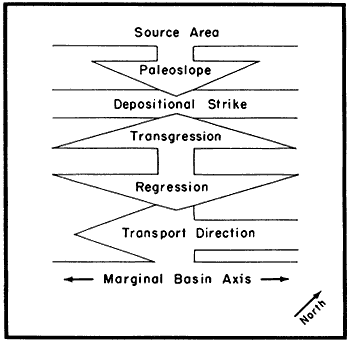
The relationships of factors affecting pre-Cincinnatian Paleozoic sedimentation in the Upper Mississippi Valley are summarized in Figure 5. The locus of deposition of Cambrian and Lower and Middle Ordovician sediments was the craton situated northwest of the Appalachian geosyncline, on which were located more rapidly subsiding intracratonic basins and essentially stable arches and domes. Cycles resulted from repeated emergence, which was caused by rejuvenation of tectonically positive portions of the craton, and submergence, which resulted from subsidence of the geosyncline and of the neighboring shelf area of the craton.
Figure 5--Model summarizing relationships of factors which affected pre-Cincinnatian Paleozoic sedimentation in the Upper Mississippi Valley area.
Regressive phases are identified in Cambrian cycles but are unknown in Ordovician cycles. It is suggested that active subsidence of the Illinois-Michigan Basin during shelf emergence at the close of the Cambrian Mt. Simon and Galesville cycles allowed deposits developed during regression to be lowered beyond the reach of subsequent erosion.
The Jordan and New Richmond cycles of the Lower Ordovician differ from previous cycles, and from the succeeding St. Peter cycle, in that their shale or argillaceous sandstone lithotopes, representing the depositional shelf environment, are poorly developed. Development of this lithotope in the other cycles is thought to have been caused by coincidence of the depositional shelf environment with the actively subsiding basin area which received large amounts of clastic sediment from a land area of moderate relief during regression. Poor development of the argillaceous lithotope in the Jordan and New Richmond cycles is interpreted to mean that the depositional shelf environment did not regress as far south as the subsiding basin, thus could not have coincided with it, that the land area exposed to erosion was lower and less extensive than at previous times of regression, and consequently, that less sediment was delivered to the shelf.
The results of this study present what is believed to be a working hypothesis for interpreting problems of Cambrian and Ordovician stratigraphy and sedimentation in the Upper Mississippi Valley. It is not meant to infer that conclusions drawn from this study are final. However, using the cyclical and environmental concept it is possible to rationalize stratigraphic relationships which have hitherto been poorly known on the local and regional scale, as well as to define geologic problems for additional investigation.
Berg, R. R., Nelson, C. A., and Bell, W. C., 1956, Upper Cambrian rocks in southeastern Minnesota: Geol. Soc. America Field Trip Guidebook no. 2, Minneapolis, p. 1-23.
Buschbach, T. C., 1964, Cambrian and Ordovician geology of northeastern Illinois: Illinois Geol. Survey Rept. Inv. 218, 90 p.
Cady, G. H., 1919, Geology and mineral resources of the Hennepin and LaSalle Quadranges: Illinois Geol. Survey Bull. 37, 136 p.
Calvert, W. L., 1962, Sub-Trenton rocks from Lee County, Virginia, to Fayette County, Ohio: Ohio Geol. Survey Rept. Inv., no. 45, 57 p.
Cloud, P. E., 1952, Facies relationships of organic reefs: Am. Assoc. Petroleum Geologists Bull., v. 36, p 2125-2149.
Cohee, G. V., 1948, Cambrian and Ordovician rocks in Michigan Basin and adjoining areas: Am. Assoc. Petroleum Geologists Bull., v. 32, p. 1417-1448.
Curray, J. R., 1960, Sediments and history of Holocene transgression, Continental Shelf, northwest Gulf of Mexico, in Recent sediments, northwest Gulf of Mexico: Am. Assoc. Petroleum Geologists, Tulsa, p. 221-266.
Dapples, E. C., 1955, General lithofacies relationship of St. Peter Sandstone and Simpson Group: Am. Assoc. Petroleum Geologists Bull., v. 39, p. 444-467.
Dapples, E. C., Krumbein, W. C., and Sloss, L. L., 1948, Tectonic control of lithologic asaociations: Am. Assoc. Petroleum Geologists Bull., v. 32, p. 1924.1947.
Driscoll, E. G., 1959, Evidence of transgressive-regressive Cambrian sandstones bordering Lake Superior: Jour. Sed. Pet., v. 29, no. 1, p. 5-15.
Dott, R. H., and Murray, G. E., 1954, Geologic cross section of Paleozoic rocks, central Mississippi to northern Michigan: Am. Assoc. Petroleum Geologists, Tulsa, 32 p.
DuBois, E. P., 1945, Subsurface relations of the Maquoketa and 'Trenton' Formations in Illinois: Illinois Geol. Survey Rept. Inv. lOS, p. 7-33.
Eardley, A. J., 1951, Structural geology of North America: Harper & Bros., New York, 624 p.
Ekblaw, G. E., 1938, Kankskee Arch in Illinois: Geol. Soc. America Bull., v. 49, p. 1425-1430.
Emrich, G. H., 1962, Geology of the Ironton and Galesville Sandstones of the Upper Mississippi Valley: Unpub. doctoral dissertation, Illinois Univ., 109 p.
Fairbridge, R. W., 1950, Recent and Pleistocene coral reefs of Anstralia: Jour. Geology, v. 58, no. 4, p. 330-401.
Freeman, L. B., 1949, Regional aspects of Cambrian and Ordovician subsurface stratigraphy in Kentucky: Am. Assoc. Petroleum Geologists Bull., v. 33, p. 1655-1681.
Gilluly, James, Waters, A. C., and Woodford, A. O., 1951, Principles of geology: W. H. Freeman and Company, San Francisco, 631 p.
Grohskopf, J. G., 1955, Subsurface geology of Mississippi Embayment of southeast Missouri: Missouri Geol. Survey, v. 37, 2nd ser., 133 p.
Hamblin, W. K., 1958, Cambrian sandstones of northern Michigan: Michigan Geol. Survey, Pub. 51, 146 p.
Hamblin, W. K., 1961, Paleogeographic evolution of the Lake Superior region from Late Keweenawan to Late Cambrian time: Geol. Soc. America Bull., v- 72, p. 1-18.
Illing, L. V., 1954, Bahaman calcareous sands: Am. Assoc. Petroleum Geologists Bull., v. 38, p. 1-95.
Johnson, J. W., 1956, Nearshore sediment movement: Am. Assoc. Petroleum Geologists Bull., v. 40, p. 2211-2232.
King, P. B., 1959, The evolution of North America: Princeton Univ. Press, Princeton, New Jersey, 190 p.
Krumbein, W. C., Sloss, L. C., and Dapples, E. C., 1949, Sedimentary tectonics and sedimentary environments: Am. Assoc. Petroleum Geologists Bull., v. 33, p. 1859.1891.
Ladd, H. S., and Hoffmeister, J. E., 1936, A criticism of the glacial-control theory: Jour. Geology, v. 44, p. 74-92.
Lee, Wallace, 1943, The stratigraphic and structural development of the Forest City Basin in Kansas: Kansas Geol. Survey Bull 51, 142 p.
Ludwick, J. C., and Wauton, W. R., 1957, Shelf-edge calcareous prominences in northeastern Gulf of Mexico: Am. Assoc. Petroleum GeologIsts Bull., v. 41, p. 2054-2101.
McKee, E. D., 1957, Flume experiments on the production of stratification and cross-stratification: Jour. Sed. Pet., v. 27, no 2, p. 129-134.
Nelson, C. A., 1956, Upper Croixan stratigraphy: Geol. Soc. America Bull., v. 67, p. 165.184.
Parker, R. H., 1960, Ecology and distributional patterns of marine macro-invertebrates, northern Gulf of Mexico, in Recent sediments, northwest Gulf of Mexico: Am. Assoc. Petroleum Geologists, Tulsa, p.302-337.
Parker, R. H., and Curry, J. R., 1956, Fauna and bathymetry of banks on Continental Shelf, northwest Gulf of Mexico: Am. Assoc. Petroleum Geologists Bull., v. 40, p. 2428-2439.
Pettijohn, F. J., 1957, Sedimentary rocks, 2nd ed.: Harper & Bros., New York, 718 p.
Pettijohn, F. J., 1962, Paleocurrents and paleogeography: Am. Assoc. Petroleum Geologists Bull., v. 46, p. 1468-1493.
Potter, P. E., and Pryor, W. A., 1961, Dispersal centers of Paleozoic and later clastics of the Upper Mississippi Valley and adjacent aress: Geol. Soc. America Bull., v. 72, p. 1195-1250.
Powers, E. H., 1935, The Prairie dn Chien problem: Iowa Univ. Studies Nat. Hist., v. 16, p. 421.448.
Pryor, W. A., 1960, Cretaceous sedimentation in upper Mississippi embayment: Am. Assoc. Petroleum Geologists Bull., v. 44, p. 1473-1504.
Quick, J. V., 1959, Troy Grove aquifer storage project, in Report to the A. G. A. Committee on Underground Storage: Northern Illinois Gas Company, 20 p.
Shepard, F. P., and Moore, D. G., 1955, Central Texas coast sedimentation: characteristics of sedimentary environment, recent history, and diagenesis: Am. Assoc. Petroleum Geologists Bull., v. 39, p. 1463-1593.
Starke, G. W., 1949, Persistent lithologic horizons of the Prairie du Chien Formation from the type section eastward to the crest of the Wisconsin Arch: Unpub. master's thesis, Wisconsin Univ.
Staufer, C. R., and Thiel, G. A., 1941, The Paleozoic and related rocks of southeastern Minnesota: Minnesota Geol Survey Bull. 29, 261 p.
Stetson, H. C., 1953, The sediments of the western Gulf of Mexico: part I--The Continental Terrace of the western Gulf of Mexico; its surface sediments, origin, and development, in Papers in Phys. Oceanog. and Meteorol: Mass. Inst. Tech. and Woods Hole Oceanog. Inst., v. 12, no. 4, p. 345.
Swann, D. H., and Willman, H. B., 1961, Megagroups in Illinois: Am. Assoc. Petroleum Geologists Bull., v. 45, p. 471-483.
Templeton, J. S., and Willman, H. B., 1963, Champlainian Series (Middle Ordovician) in Illinois: Illinois Geol Survey Bull. 89, 260 p.
Twenhofel, W. H., Raasch, G. O., and Thwaites, F. T., 1935, Cambrian strata of Wisconsin: GeoL Soc. America Bull., v. 46, p. 1687-1743.
Ulrich, E. O., 1924, Notes on new names in the table of formations and on physical evidence of breaks between Paleozoic Systems in Wisconsin: Wisc. Acad. Sci., Art., and Letters, Trans., v. 21, p. 71-107.
Ulrich, E. O., and Resser, C. E., 1930, The Cambrian of the Upper Mississippi Valley, part I: Milwaukee Pub. Museum Bull., v. 12, no. 1, p. 1-122.
Van Andel, Tj. H., 1960, Sources and dispersion of Holocene sediments, northern Gulf of Mexico, in Recent sediments, northwest Gulf of Mexico: Am. Assoc. Petroleum Geologists, Tulsa, p. 34-55.
Van Andel, Tj. H., and Curray, J. R., 1960, Regional aspects of modern sedimentation in northern Gulf of Mexico and similar basins, and paleogeographic significance, in Recent sediments, northwest Gulf of Mexico: Am. Assoc. Petroleum Geologists, Tulsa, p. 345-364.
Van Andel, Tj. H., Postma, H., and others, 1954, Recent sediments of Gulf of Paria, in Reports of the Orinoco Shelf Expedition, Y. 1: Kon. Nederl. Akad. Wetensch. Verh., v. 20, no. 5.
Wells, A. J., 1960, Cyclic sedimentation: a review: GeoL Mag., v. 97, no. 5, p. 389-403.
Willman, H. B., and Templeton, J. S., 1952, Cambrian and Lower Ordovician exposures in northern Illinois: Illinois Geol. Survey Circ. 179, p. 109-125.
Woodward, H. P., 1961, Preliminary subsurface study of southeastern Appalachian Interior Plateau: Am. Assoc. Petroleum Geologists Bull., v. 45, p. 1634-1655.
Workman, L. E., and Bell, A. H., 1948, Deep drilling and deeper oil possibilities in Illinois: Am. Assoc. Petroleum Geologists Bull., v. 32, p. 2041-2062.