| Original published in W.W. Hambleton, ed., 1959, Symposium on Geophysics in Kansas: Kansas Geological Survey, Bulletin 137, pp. 219-224 | ||
Phillips Petroleum Company
The complete article is available as an Acrobat PDF file.
A radioactivity survey was made over Rose Dome, Woodson County, Kansas, to determine whether intrusive granite rocks would produce a radioactive anomaly. Two traverses indicate the presence of the granite on the dome.
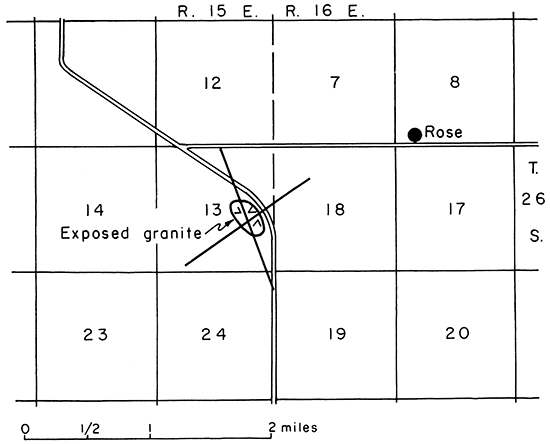
Rose Dome is located in Eminence Township, Woodson County, in the NE SE sec. 13, T. 26 S., R. 15 E., approximately 8 1/4 miles south of Yates Center and 1 mile west and 1/2 mile south of Rose (Fig. 1). Granitic rocks with intrusive contacts are exposed in places over a 40-acre area on the dome. Most of the igneous rocks are associated with five prominent hills; the hills have no definite alignment.
Figure 1--Location of radioactivity traverses, Rose Dome, Woodson County.
A radioactivity survey was made to determine whether the igneous rocks produced radioactive anomalies and to establish a relation between the anomalies and the occurrence of igneous rocks.
The Weston shale of the Missourian Series crops out over most of the area. The Weston contains local beds of limestone and beds of shaly and even-bedded sandstone. Beneath the Weston are several hundred feet of lower Pennsylvanian sedimentary rocks, which are in turn underlain by Mississippian beds, mostly limestone. Marine limestone and some sandstone of Cambrian and Ordovician age lie beneath Mississippian and overlie Precambrian basement rocks. Granite intrudes rocks of Missourian age. Rose Dome is a structural high on the northern flank of the Cherokee Basin.
Twenhofel (1917, p. 363) believed the hills at Rose Dome owed their origin to the resistance of the granite boulders as compared with the resistance of the surrounding rock. He concluded that the boulders reached their positions through the agency of ice. Powers (1917, p. 150) suggested that the boulders were derived from a local granite elevation which was undergoing erosion during the deposition of the Weston shale. Darton (1918) believed that the parent rock for the granite in Woodson County was to be found on the northern end of the buried mountain ridge of central Kansas.
In a later paper, Twenhofel (1926, p. 412) discarded the idea of glacial origin for the boulders. He recorded the presence of contact metamorphic minerals in the shale and concluded that the blocks are surface exposures of a granite mass intruded into Pennsylvanian rocks.
Twenhofel and Bremer (1928, p. 758) recorded the fact that a well drilled 3 miles southeast of the Rose Dome penetrated a black rock for 102 feet. The black rock was identified as peridotite. They suggested that the peridotite is a dike or intrusive sheet that is connected in some way with the Rose Dome intrusive.
Knight and Landes (1932, p. 15) suggested that "a parent body of magma first intruded the crystalline shell underlying Woodson and adjacent counties. Cupolas on the top of this deep-seated igneous body broke through the Precambrian rocks and arched the overlying sedimentary strata at the same time sending out dike offshoots. With crystallization of the magma in the cupola, hydrothermal solutions were expelled which worked upward through the rocks causing metamorphism of the shales, sandstones, limestones, and some of the dikes."
Hambleton and Merriam (1955), subsequent to this radioactivity survey, made a survey of vertical magnetic intensity in northern Wilson County and southern Woodson County that included the Rose Dome area.
Many igneous rocks are more radioactive than sedimentary rocks. The sedimentary rocks of the earth's crust are radioactive in different degrees. Generally, dark-colored shales are more radioactive than are sandstones, and most sandstones are more radioactive than pure limestones. Thus, it may be possible to detect the presence of igneous rock in sedimentary strata.
The radioactivity survey was made with a Geiger counter during March 1948. The instrument was checked for cosmic radiation during the course of the survey; background averaged 11.5 counts per minute. Two traverses (Brunton compass) were made; one along a line trending N 20° Wand the other along a line trending N 55° E (Fig. 1). The traverses were begun near the center of the area in which granite is exposed, and readings were taken at 30-foot intervals for the first 600 feet on each side of the starting point and at 300-foot intervals for an additional 2,700 feet on each side of the starting point. The traverses crossed the center of the dome.
The results of the survey are shown in Figures 2 and 3. A radioactive anomaly of about 19 counts per minute is present over the center of the dome and the exposed granite on both of the traverses. No other counts on either traverse were as great as the count at the center of the dome; other counts approximate average cosmic radiation background count.
Figure 2--Radioactivity traverse trending N 20° W.
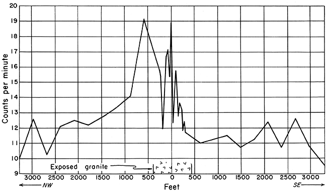
Figure 3--Radioactivity traverse trending N 55° E.
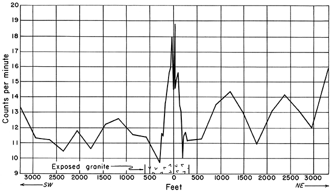
Seemingly the radioactivity anomaly at the center of the dome is caused by the granite, and one can differentiate between granite and surrounding sedimentary rocks.
The writer wishes to thank Dr. R. M. Dreyer of the University of Kansas, who supervised the work and who made many helpful suggestions to the author. The writer wishes also to thank Dr. Mark Jewett of the Kansas Geological Survey, who gave helpful advice and information on the survey area.
Darton, N. H. (1918) Structure of parts of the central Great Plains: U. S. Geol. Survey, Bull. 691-A, p. 5. [available online]
Hambleton, W. W., and Merriam, D. F. (1955) Magnetic anomalies in Wilson and Woodson Counties, Kansas: Kansas Geol. Survey, Bull. 114, pt. 3, p. 115-128. [available online]
Knight, G. L., and Landes, K. K. (1932) Kansas laccoliths: Journal Geol., v. 40, p. 1-15.
Powers, S. (1917) Granite in Kansas: Am. Jour. Sci., 5th ser., v. 44, p. 146-150.
Twenhofel, W. H. (1917) Granite boulders in the Pennsylvanian strata of Kansas: Am. Jour. Sci., 5th ser., v. 43, p. 363-380.
Twenhofel, W. H. (1926) Intrusive granite of the Rose Dome, Woodson County, Kansas: Geol. Soc. America, Bull., v. 37, p. 403-412.
Twenhofel, W. H., and Bremer, Bernard (1928) An extension of the Rose Dome intrusives, Kansas: Am. Assoc. Petroleum Geologists, Bull., v. 12, p. 757-762.
Kansas Geological Survey
Comments to webadmin@kgs.ku.edu
Web version Dec. 6, 2013. Original publication date 1959.
URL=http://www.kgs.ku.edu/Publications/Bulletins/137/Hartenberger/index.html