| Original published in W.W. Hambleton, ed., 1959, Symposium on Geophysics in Kansas: Kansas Geological Survey, Bulletin 137, pp. 275-280 | ||
The Globe Oil and Refining Company
The complete article is available as an Acrobat PDF file.
Geophysical work in Pratt County, Kansas, is characterized by many unique problems. These problems include selection of a suitable reference plane marker for isotime mapping, correct correlation of reflections in places where section thickening produces additional reflections, and correct correlation of reflections in areas of complex faulting and truncation. Methods of solving these problems are outlined.
Many problems are encountered in entering upon a geophysical program in any area. In Pratt County, a seismic, program must deal with a combination of buried topography and structure, marked variation in weathering corrections from hole to hole, and correct correlation of record events where section thickening introduces new reflections or where faulting and truncation obscure correlation. Inasmuch as most central Kansas areas have no particular problems from the standpoint of record quality or shooting patterns, solutions to these problems are found in continuous profiling methods, isotime mapping and selection of a suitable reference plane, and application of appropriate geological knowledge and techniques. This paper outlines three major problems of the Pratt County area and recommends solutions to the problems.
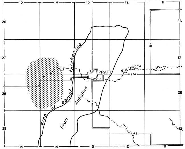
Most Kansas structures have very little more closure than the margin of error involved in making a seismic structural map. In addition, uphole corrections for weathering are necessary in most areas, and these corrections may show marked variation from hole to hole. Consequently, isotime maps also are prepared, because errors are minimized and many of the effects of variation in weathering are eliminated. Isotime mapping, however, requires selection of a consistent shallow reference plane as an upper isotime marker. Over most of central Kansas, the Stone Corral ("Cimmaron anhydrite") is a good shallow reference plane and satisfies the requirement that an isotime marker be a nearly level datum. In Pratt County, however, the Stone Corral is not useful as a reference plane, because the anhydrite, which is normally about 25 feet thick, becomes dolomitic in places and loses its identity as a marker and because structural relief is introduced in many places. The area of greatest change in the anhydrite is shown on Figure 1. Structural relief of about 100 feet is illustrated between the Texas Company No. 1 Quinn well (sec. 4, T. 28 S., R. 14 W.), where the anhydrite is at +1,090 feet and the Arbuckle is at -2,678 feet and the Lion No. 1 Maercker well (sec. 8, T. 28 S., R. 14 W.) where the anhydrite is at +1,167 feet and the Arbuckle is at -2,693 feet. These conditions, which may be attributed to facies change or slumping due to solution of underlying salt, are evident to a lesser degree over the entire county.
Figure 1--Map showing area of marked change in anhydrite (patterned area), location of Pratt Anticline, and area of abrupt thickening of basal Pennsylvanian and pre-Pennsylvanian sediments.
Solution of this problem lay in finding an alternate reference plane marker that was not subject to the variation exhibited by the anhydrite. Examination of electric logs, sample logs, and seismograms revealed that the base of the Wellington salt was a stable marker. Nearly all seismic companies working not only in Pratt County but in many of the adjacent counties have since adopted this marker and have used it with success in isotime mapping.
The Pratt Anticline is a major structural feature that bisects Pratt County from north to south (Fig. 1). Seismograms taken over the crest of Pratt Anticline are characterized by two sharp reflection events in the deeper bands of energy return, The upper event is thought to be a reflection from the Viola limestone and the lower event is a near Arbuckle Group reflection. Seismograms taken over the western flank of Pratt Anticline in adjacent western areas exhibit three reflection events in the deeper bands of energy. If the upper reflection is picked as a Viola reflection, the resulting seismic map exhibits a series of large structures, which do not exist.
Solution to this problem of correct correlation lies in an understanding of the geology of Pratt Anticline. The west flank of Pratt Anticline is characterized by steeper dips than the east flank and by thickening of basal Pennsylvanian and pre-Pennsylvanian sediments. Addition of 100 feet of section at the base of the Pennsylvanian and the top of the pre-Pennsylvanian section introduces an additional reflecting bed, which is responsible for the third reflection event. Problems of this kind can best be solved by construction of subsurface isopach maps encompassing the interval from the Lansing to the Arbuckle. In addition, continuous profiling through these areas of changing section also will help to identify the seismic reflections correctly.
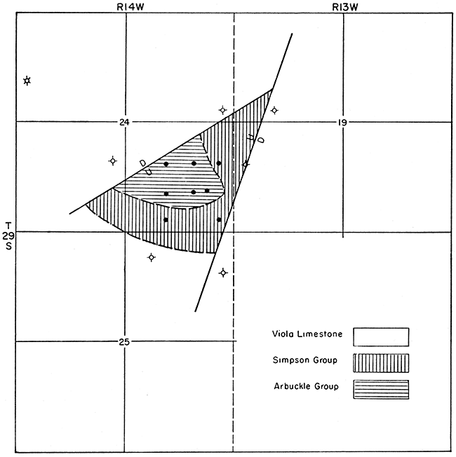
The eastern flank of Pratt Anticline, as shown in Figure 2, is characterized by a series of large and small faults paralleling the anticline. The average throw of the larger faults is about 150 feet. In addition, there is truncation of the pre-Pennsylvanian section in association with the small faulted structures and onlap of basal Pennsylvanian sediments. An example of this condition is the Coats structure (Fig. 3), where Pennsylvanian rocks rest on Viola, Simpson, and Arbuckle rocks at the crest of the truncated structure.
Figure 2--Map showing faults or suspected faults associated with Pratt Anticline.
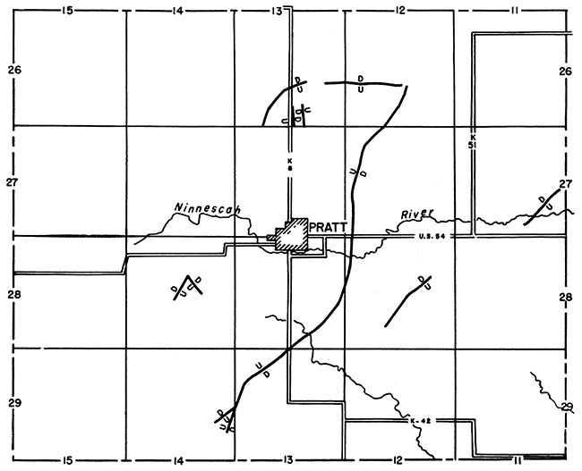
Figure 3--Map of pre-Pennsylvanian in Coats faulted area, Pratt County, showing truncation of Viola limestone, Simpson Group, and Arbuckle Group.
Reflections may be from the Viola on one record, Simpson on the next record, and Arbuckle on the succeeding record, but similarity in the appearance of reflections at the same depth could lead to an erroneous correlation across the structure.
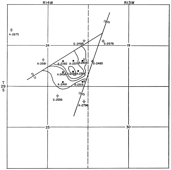
Solution of this problem is similar to the solution recommended for problems on the west flank of Pratt Anticline. It is absolutely necessary to obtain a seismic reflection from rocks below the top of the Viola if an exploration program for Ordovician production is to be successful. In addition, structural contour maps on the Arbuckle (Fig. 4) and isopach maps for the Lansing-to-Arbuckle interval should be made, and continuous profiling should be employed in the seismic program.
Figure 4--Structural contour map on top of Arbuckle Group, Coats faulted area, Pratt County. Contour interval 50 feet.
In complex areas such as western Pratt County there is never enough geophysical and geological information to solve every problem that arises. Problems can be resolved, however, if the geologist will make full use of electric logs and sample top data on every well that is to be tied to the seismic program. In addition he should make structural contour maps on the Arbuckle as well as isopach maps for the Lansing-to-Arbuckle interval. In areas of poor record quality, suspected faulting, or rapid thickening, continuous profiling should be employed in place of spot correlation shooting, the more economical program in regional reconnaissance. Continuous profiling also should be used to check critical dips across any anomalous feature before drilling is begun. Any geophysical program will be much more successful if thorough geologic study is made first and complete coordination is maintained between geophysical and geological departments throughout the program.
Kansas Geological Survey
Comments to webadmin@kgs.ku.edu
Web version Dec. 19, 2013. Original publication date 1959.
URL=http://www.kgs.ku.edu/Publications/Bulletins/137/Brewer/index.html