| Original published in W.W. Hambleton, ed., 1959, Symposium on Geophysics in Kansas: Kansas Geological Survey, Bulletin 137, pp. 249-274 | ||
Keating Drilling Company
The complete article is available as an Acrobat PDF file.
The Koelsch Southeast field, sec. 25 and 36, T. 24 S., R. 14 W., Stafford County, Kansas, is one of many small oil fields in the area that produce from the Arbuckle dolomite. Accumulation of oil is the result of a small structural closure on the Arbuckle with approximately 40 feet of relief. The local anomaly is superimposed on the axis of a regional southwestwardplunging anticline. Conventional seismic work had failed to locate the oil field. Three dry holes had been drilled in proximity to the field before its discovery. A seismic survey, using a somewhat unusual technique of interpretation and careful precise field procedure, outlined the anomaly on which production was found. A very close comparison can be made between seismic and subsurface data. The history of the discovery and development of the field is a classic example of the benefits to be derived from a carefully planned, well conceived exploration program based on unusually close cooperation and understanding between geologists and geophysicists. The methods used have wide application where comparable circumstances and conditions are anticipated.
The Koelsch Southeast field was discovered by Hilton Drilling Company No. 1 Koelsch, in the NE SE SW sec. 25, T. 24 S., R. 14 W., Stafford County, Kansas. The pool is approximately 6 miles southwest of St. John, county seat of Stafford County, and 4 miles southeast of Dillwyn. Figure 1 shows the location of the pool in relation to other pools and larger towns in the vicinity. Locations of discovery wells are shown in Figure 2. Hilton No. 1 Koelsch was completed Nov. 14, 1952, pumping 3,000 barrels of oil daily from the Arbuckle dolomite, which was encountered at a depth of 4,187 feet and penetrated to 4,191 feet.
Figure 1--Map showing location of Koelsch Southeast pool (black). Patterned areas are pools discovered because of same reconnaissance seismic survey that resulted in discovery of Koelsch Southeast.
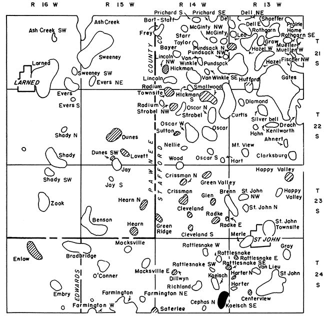
Figure 2--Map showing location of discovery wells.
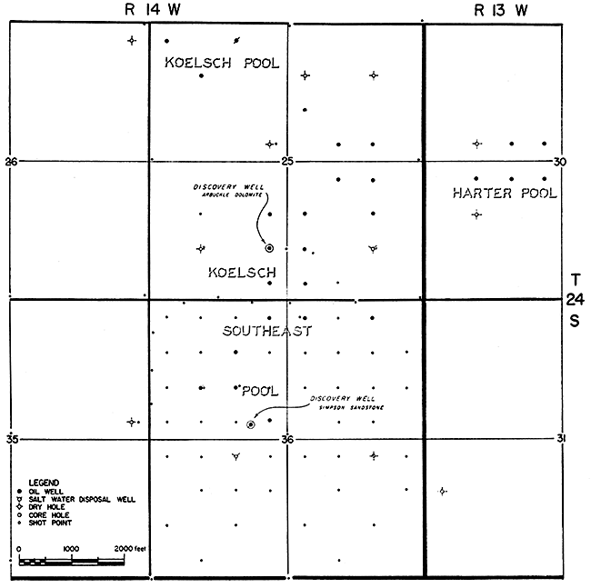
The discovery well in a sandstone of the Simpson Group, Westgate-Greenland Oil Company and Manhart, Millison, & Beebe No. 5 Kachelman in the cen. S2 SE NW sec. 36, T. 24 S., R. 14 W., was completed September 18, 1953, pumping 110 barrels of oil daily from a depth of 4,180 to 4,193 feet.
Fourteen producing wells and six dry holes were drilled during the development of the Koelsch Southeast field. Thirteen of the wells produced from the Arbuckle dolomite and one from the Simpson Group. Two of the dry holes were converted to salt-water disposal wells.
The entire area mapped by the reconnaissance seismic survey that resulted in the discovery of the Koelsch Southeast pool and other pools had been repeatedly surveyed, using conventional seismic methods, over a period of more than 25 years with very little success. Determination of the amount of vertical relief and the areal extent of a structural anomaly is the major problem in a seismic survey of any region. The structures from which oil is produced in this general area usually have closure ranging from 10 to 40 feet, and are a major problem in successful exploration in that an unusually small margin of error may be tolerated. This entire survey was conducted with precision well beyond the limits of normal seismic accuracy, even though easily applied techniques were used.
Small but extremely significant variations in the velocity of the weathered layer and the stratified rocks underlying the weathered layer but above the Stone Corral anhydrite create a problem that usually cannot be resolved with sufficient accuracy to map small anomalies found in the territory. Because of abrupt changes in the thickness, character, and fluid content of the unconsolidated surface and near-surface deposits and the underlying bedded strata to a depth of approximately 800 feet, these rocks are characterized by small but abrupt, hence significant, changes in velocity.
The case history of this pool is another of a series of unusually fine examples of the close understanding and cooperation between geologists and geophysicists so necessary for an efficient, accurate, successful exploration program. A similar example recently was outlined by Beebe and Ballou (1956).
Previous conventional seismic work in the area had 'not generally been of the required accuracy to yield oil discoveries. The magnitude of structural relief necessary to yield commercial quantities of oil is so small that it is well below the normal limit of error in conventional seismic surveying. Careful definition and analysis of the problem led to the conclusion that a reference-plane method, generally known as the "anhydrite method," was most feasible for obtaining the necessary accuracy. This method requires good subsurface geological control and precise determination of all markers, particularly the Stone Corral, for effective evaluation of seismic results.
Before the reconnaissance seismic survey was begun, all available electric logs were obtained, and all important marker beds were correlated precisely by one geologist. Especial care was devoted to. correlation of the top of the Stone Corral anhydrite because drillers had reported erroneous. depths. Accurate detailed subsurface structural and isopachous maps were prepared for the area to be covered by the reconnaissance seismic survey.
The general area was selected for this type of survey for the following reasons:
The reconnaissance seismic program was begun early in 1951 by Geophysical Consultants, Inc., which completed the entire program under supervision of Manhart, Millison, & Beebe. The correlation method was selected because it is much more flexible and less expensive than continuous profiling. In areas where good records can be obtained, correlation technique has every advantage over conventional continuous profiling, if faulting is not a factor and if structural relief is less than 125 feet (one cycle).
Correlation shot points were located at each section corner and in the center of each section. Shot points were placed at the exact location of each dry hole in the vicinity, and a supreme effort was made to obtain seismic records of highest quality at these points for comparison with well records, thus allowing the seismic work and the subsurface geology to be tied together with precision. After the initial reconnaissance points were appraised and anomalies of interest generally outlined, additional shot points were located near the center of each quarter section within the area of interest. If a structural anomaly of sufficient size and relief was confirmed after the results were thoroughly reviewed and evaluated, points were shot at selected 10-acre locations over the prospect so that the precise relief, configuration, and amount of critical dip, which in this vicinity is generally northward and eastward, could be determined. A location could then be selected for testing by drilling.
A total of 25 reconnaissance points, involving approximately 3 days of work, outlined this particular anomaly. An additional 28 detail points, requiring approximately 3 1/2 days, completed the program before a drilling location was recommended. While negotiations were carried on for additional leases, the discovery well was located by Hilton Drilling Company on a farmout from a major company.
The presence of the structural anomaly had been suspected for several years. Three dry holes had been drilled before the discovery of the pool. The first failure was H. A. Hershfield and Co., Inc., No. 1 Shirk, in the SE SE NE sec. 35, only two locations southwest of a producer. This dry hole was completed March 19, 1946. The next test well in the vicinity, Keyes Drilling Company No. 1 Abbott in the SE SE NW sec. 25, was completed June 6, 1947, only two locations in two directions from producers completed after discovery of the field. The third "dry hole," M. B. Armer No. 1 Mackley, in the NW NW NE sec. 36, was completed June 16, 1950, at total depth of 4,269 feet, 60 feet in the Arbuckle dolomite. This should have been the discovery well in the field. After completion of Westgate-Greenland and Manhart, Millison, & Beebe No. 1 Kachelman in the NE NE NW sec. 36, west offset to No. 1 Mackley, these operators washed down No. 1 Mackley, set casing to total depth, perforated and acidized the Arbuckle, and completed the well, pumping 612 barrels of oil daily.
After the discovery had been made, 21 additional seismic points were shot to evaluate potential drilling locations, and the companies conducting the survey commenced drilling No. 1 Kachelman in the NE NE NW sec. 36, which was completed as an oil well two locations south of the discovery. The operators were so confident of the accuracy of the seismic work that their initial test well offset the Armer No. 1 Mackley dry hole, although at that time it was not realized that the Mackley dry hole was structurally sufficiently high to be productive.
The Meade Group, of Pleistocene age, underlies the unconsolidated dune sands that cover the surface in the Koelsch Southeast area. Rocks of the Meade Group are important aquifers in the region. The group consists of poorly sorted sand, gravel, and silt, and ranges widely in the proportions of these materials over short distances, both laterally and vertically. The deposits are irregular lenses, and some beds are loosely cemented by calcium carbonate. Crystalline igneous and metamorphic rocks have been the source of most of the material, although pebbles of Cretaceous sandstone and "ironstone" are numerous (Latta, 1950). Thickness of the Meade Group in the Koelsch Southeast area ranges from 150 to 200 feet.
Subjacent to the Meade Group, and separated from it by an angular unconformity, are stratified rocks of the Comanchean Series, of Cretaceous age. The Kiowa shale, uppermost formation of the Comanchean Series, is a marine deposit consisting of shale containing numerous sandstone lenses and a few thin beds of limestone. Some of the sandstone lenses are soft, porous, and contain water, whereas others are hard and quartzitic. The Kiowa formation is approximately 25 feet thick.
The Cheyenne sandstone underlies the Kiowa and is less than 50 feet thick. It consists of porous to tightly cemented fine- to medium-grained sandstone, siltstone, and sandy clay and shale. The more porous sandstone beds contain water.
Comanchean rocks were deposited on the deeply eroded surface of rocks of Permian age and are separated from them by a pronounced angular unconformity. Permian rocks in the area attain a thickness of approximately 2,500 feet. The upper Permian rocks, of Leonardian age, are partly non-marine, and are composed of alternating red shale and sandstone or siltstone containing numerous layers of gypsum, anhydrite, and mudstone. The basal part of the series contains the Hutchinson salt member, which is approximately 250 feet thick and underlain by a thick section of anhydrite and shale. The first good subsurface and seismic marker, the Stone Corral anhydrite, is encountered at approximately 800 feet below the top of Leonardian Series. Lower Permian rocks, of Wolfcampian age, are principally marine and consist of alternating limestone and shale. Beds of red shale are not uncommon.
Classically, rocks of Permian age are separated from the older deposits of the Pennsylvanian System by an unconformity. This unconformity is not discernible in the subsurface in this part of Kansas, and the contact cannot be identified. Pennsylvanian rocks are approximately 2,400 feet thick in the vicinity of the Koelsch Southeast pool and consist of the Virgilian, Missourian, and Desmoinesian Series in descending order. The Virgilian Series is a typical cyclic deposit of alternating shale, thin sandstone, and limestone, and numerous thin layers of coal and black carbonaceous shale. Limestones become increasingly thick and prominent in the lower Virgilian.
Strata of the Missourian Series are thick limestone and relatively thin shale and are of great economic importance in Stafford County. Numerous porous oolicastic zones are developed in the upper 200 feet of the Missourian section, and in places they yield oil in this part of Kansas. Although no production has been developed from this part of the section in the Koelsch Southeast pool, several pools in the vicinity, including the Koelsch pool at the northwestern edge of the map area, produce from these zones.
Rocks of Desmoinesian age underlie the Missourian and consist of limestone and shale. In places, basal conglomerate is found near the base of the Pennsylvanian. Most of the lower Desmoinesian and all of the pre-Desmoinesian Pennsylvanian sediments are absent in this part of Kansas. Younger rocks exhibit progressive northward onlap over truncated pre-Pennsylvanian rocks on the flank of the Central Kansas Uplift.
Most of the strata representing the Mississippian have been eroded from the Koelsch Southeast area, leaving only about 50 feet of a weathered remnant of questionable "Kinderhook" shale.
Subjacent to Mississippian rocks, but separated from them by a regional unconformity, is the Viola limestone of Ordovician age. The Viola limestone is approximately 150 feet thick. The Simpson Group, approximately 40 feet thick, underlies the Viola, and is composed of waxy green shale, locally sandy, and thin hard sandstone.
The Arbuckle dolomite, Cambro-Ordovician in age, underlies the Simpson. The Arbuckle is the principal oil reservoir in the general area, and is separated from the overlying Simpson by a regional unconformity. The Arbuckle is composed of massive dolomite and dolomitic limestone characterized by numerous fractures and secondary vugular porosity. Chert is common, and in places in the upper part of the Arbuckle, is oolitic. The Arbuckle has been penetrated in one well where it is 498 feet thick and rests unconformably on Precambrian basement rocks. No basal Cambrian sandstone, which in many places underlies the Arbuckle and overlies the Precambrian, is present.
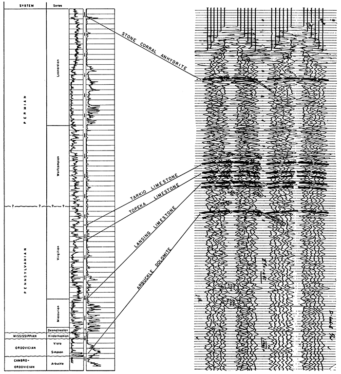
Figure 3 is a typical electric log from the field, showing stratigraphic sequence and comparison between the electric log and a seismic record taken at the same location.
Figure 3--Comparison of typical electric log and seismic record.
Regionally, the Koelsch Southeast pool lies on the southern flank of the Central Kansas Uplift. More specifically, it is located near the southeastward-plunging axis of the Pawnee Rib, one of the principal southeast-trending component arches of the major uplift. The regional grain of the strata is aligned in a northwest-southeast direction. Superimposed on this older grain is a series of southwestward-plunging anticlinal axes that are a result of later structural movements. The structural anomaly affording production in the Koelsch Southeast field is a local closure superimposed on one of these axes.
Many small oil pools are located on local domal culminations on these axes. Larger fields are found at the intersection of the two lines of folding. Local structures affording oil production are generally small; the amount of vertical closure on the top of the Arbuckle ranges from 30 to 50 feet and areal extent ranges from 80 to 400 acres. Inasmuch as the regional dip of the sedimentary rocks is south-southwestward, critical dip, which produces closure, is in a northerly to northeasterly direction.
Figure 5 is a subsurface map contoured on the top of the Arbuckle dolomite, which reveals a narrow southwestward-plunging anticline having approximately 40 feet of structural closure. The closure area is approximately 1 mile long and 1/2 mile wide.
The Arbuckle surface on the Central Kansas Uplift has been truncated and locally deeply dissected, creating a typical karst topography. Local topographic irregularities are common on the top of the Arbuckle even where overlain by the Simpson formation. The magnitude of the dissection is not as great as it is higher on the Central Kansas Uplift, however, where rocks of Missourian age rest directly on the eroded Arbuckle or older surfaces. The structure map on the top of the Arbuckle depicts the attitude of this erosional surface plus all subsequent folding. Local accumulation of oil in the Arbuckle may be controlled partly by these topographic irregularities on the Arbuckle surface, although the accumulation of oil generally is controlled primarily by structure.
There are numerous unconformities of various magnitudes in the stratigraphic section. A major unconformity at the base of the Pennsylvanian separates upper Desmoinesian units from weathered "Kinderhook" shale. The major period of local warping and contemporaneous and subsequent erosion probably occurred near the end of Mississippian time and extended into early Pennsylvanian time. During this period, all pre-Pennsylvanian rocks, including Arbuckle, basal Paleozoic sandstone, and portions of the basement, were removed from the highest parts of the Central Kansas Uplift. Pennsylvanian deposits progressively lapped onto this erosional surface as the Anadarko Basin subsided southward. This major unconformity creates some difficult problems in seismic exploration, and uniformly good reflections from the pre-Pennsylvanian are the exception rather than the rule. In the Koelsch Southeast area, fortunately, good reflections were obtained from the pre-Pennsylvanian, although it is doubtful that they came from the Simpson-Arbuckle interface.
Local structures usually are evident in strata above this unconformity; successively younger beds show lesser amounts of relief. Some of the larger local features show closure on the shallow Stone Corral anhydrite. Several of the larger oil fields in the area were found by core drilling to this formation, and most of the anomalies show some abnormal structure on the Stone Corral. The Koelsch Southeast field shows approximately 10 feet of closure on this formation, as may be seen in Figure 9. These structural features having progressively less closure in younger rocks near the surface have often been ascribed to differential compaction over pre-existing structural and topographical features. A critical analysis of the data and a comparison with areas farther southward in Oklahoma, where more intense folding is known, strongly support the theory that there were successive periods of warping and that the structures were gently rejuvenated throughout the Pennsylvanian and probably later periods. The writer believes that the anticlinal axes and most of the local structural features were formed on pre-existing lines of weakness by continued differential subsidence into the Anadarko Basin.
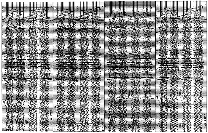
The survey of the area was made using a conventional 24-trace Century recording truck equipped with one geophone per trace. Generally, twelve station straddle spreads were used at each shot hole, and records were dually recorded with a 24- trace camera; one half of the record was recorded without mixing, and the other half recorded using an overlap or mixing. The critical factors, particularly in recording shallow reflections from and near the Stone Corral anhydrite, are the length of the spread, spacing of the geophones, and instrument presuppression level. The common practice is to predetermine the best pre-suppression level or filter setting, and then to vary the hole depth, the spread length, and the explosive charge until optimum conditions can be found. As a general practice, three to four records were made from each hole to obtain the best-possible comparison. Figure 4 shows four typical correlation records, on which the principal reflections are clearly marked.
Figure 4--Correlation of four typical seismic records.
The depth and size of the explosive charge is of the utmost importance in obtaining good shallow reflections. The length of the spread also is important. Present-day instruments, unusually sensitive to signals, allow the use of a minimum explosive charge. Too great a charge obliterates shallow events; therefore, everyprecaution must be taken against overshooting. Good records may be obtained by use of as little as 1/4 pound of explosive. Previous seismic work in the area often did not produce identifiable shallow reflections with any consistency.
Record quality is the principal factor in determining the success of a seismic program in this area. Records of good quality can be obtained over most of the area, and many reflections are readily identifiable if proper field methods and techniques are used. The matter of record quality cannot be overemphasized, and the greatest care must be exercised in picking reflections. The day-to-day mental attitude of the interpreter is important in meticulous picking of reflections with the precision of the width of a pencil mark, which amounts to one millisecond on the average record. If the toast was burned at breakfast time, the day's work may be substandard.
Because the seismic problem in any particular area is to map structural relief necessary for the accumulation of oil and gas, the problem becomes particularly acute where the necessary structural relief is unusually small. When erratic variations in seismic travel time are introduced by abrupt changes in thickness and composition of the weathered layer and nearsurface bed rock, errors introduced by misleading corrections for weathering may be as large as or larger than the amount of structural relief, and the seismic results may be completely misleading.
If the Stone Corral anhydrite reflection is used as a reference plane, in place of an arbitrary elevation datum plane, no weathering corrections are necessary. All reflections below the Stone Corral anhydrite are referred to this reflection, which is assumed to be flat locally, time intervals are used in preparing maps, and an isochron map is constructed. Consequently, variations above the Stone Corral anhydrite introduced by erratic velocities in the shallow layers equally affect the deeper reflections, and there is no influence on the travel time between the Stone Corral anhydrite and the deeper reflections.
Comparatively speaking, use of the so-called "anhydrite reference plane" produces far more accurate results than conventional methods. Nevertheless, there are two possible sources of error that must be continuously considered. In all seismic mapping there is always the possibility of velocity variations in deeper strata. This potential error usually does not affect seriously the interpretation of small local structures in this vicinity. On occasion, however, serious errors have resulted because of lack of knowledge of interval velocities in pre-Stone Corral anhydrite deposits.
Inasmuch as it is necessary to assume that the Stone Corral anhydrite is a plane, a second, more serious, local error can be introduced. This formation is influenced by local structural conditions. Determination of structure of the lower beds depends on the attitude of the Stone Corral anhydrite. Over most of the area, warping of the Stone Corral anhydrite is gentle, and if appreciable thinning of intervals between the Stone Corral anhydrite and lower reflections is evident, generally it may be assumed that warping of the Stone Corral anhydrite is anticlinal. Locally, however, the attitude of the reflection plane may become critical in evaluating a structural anomaly and potential drilling locations on an anomaly. Nevertheless, the sum total of all the points shown by a conventional seismic structural map of the Stone Corral anhydrite will give ample warning of an unusual situation. Individual Stone Corral points that do not fit into a pattern become suspect. In such cases, a core hole may be drilled to assist in evaluating an anomaly or a particular location. The core hole is drilled through the Stone Corral anhydrite and electrically logged, and the interval from the actual depth of the Stone Corral anhydrite to lower reflecting horizons is computed to determine relative depth and structural position. Two such core holes were drilled on the Koelsch Southeast prospect during the course of development work to evaluate potential drilling locations because appreciable thinning of the pre-Stone Corral anhydrite intervals was disclosed by the seismic survey and Stone Corral seismic points were suspect. In both places, it was found that the Stone Corral point was low structurally and that the depth to the producing formation was too great for production to be anticipated. A well drilled later near one of these points for disposal of salt water confirmed these calculations, although oil was found in the Simpson sandstone. This is reminiscent of the amusing story of the irate rancher who had tried for years to drill a water well, but could find only oil.
In summarizing the general principles involved in a seismic survey of this and similar areas, the following fundamentals are obvious:
The Koelsch Southeast field has been completely developed. Electric logs are available on most of the test wells so that comparisons may be made between subsurface and seismic information. Seismic data are in close network throughout the southern half of the pool area, and they outline some of the more minute structural features not apparent from subsurface data. The northern portion of the feature was not detailed, and paucity of seismic data is reflected by the more generalized contours. In order to compare conventional seismic maps with subsurface structural maps and subsurface isopachous maps with seismic isochron maps, a series of illustrations has been prepared. Most of the subsurface points were obtained from electric logs, which were made on most of the test wells in the pool.
Figures 5 and 6 compare the structure on the Arbuckle dolomite as mapped from well data with a conventional seismic structural map on the pre-Pennsylvanian. As mentioned earlier, there is uncertainty as to the geologic correlation of the seismic pre-Pennsylvanian reflection. Figure 5, the Arbuckle structural map, shows a southwestward-plunging anticline having about 40 feet of closure and characterized by strong southeast dip. Figure 6, a conventional seismic structural map on the pre-Pennsylvanian, shows an anticline in approximately the same position and having approximately the same crestal area as shown in Figure 5. This feature is overshadowed, however, by an apparent structural high centering around the dry hole in the SE SE NW sec. 25. On the basis of this map alone, it is doubtful that the pool would have been drilled after the dry hole mentioned above. The numerous irregularities and subsidiary features, for the most part, are a result of variations in velocity in the weathered zone and near-surface consolidated rocks. Mis-ties between seismic and subsurface data of as much as 75 feet may be observed.
Figure 5--Subsurface structure map, top of Arbuckle dolomite. Contour interval 10 feet.
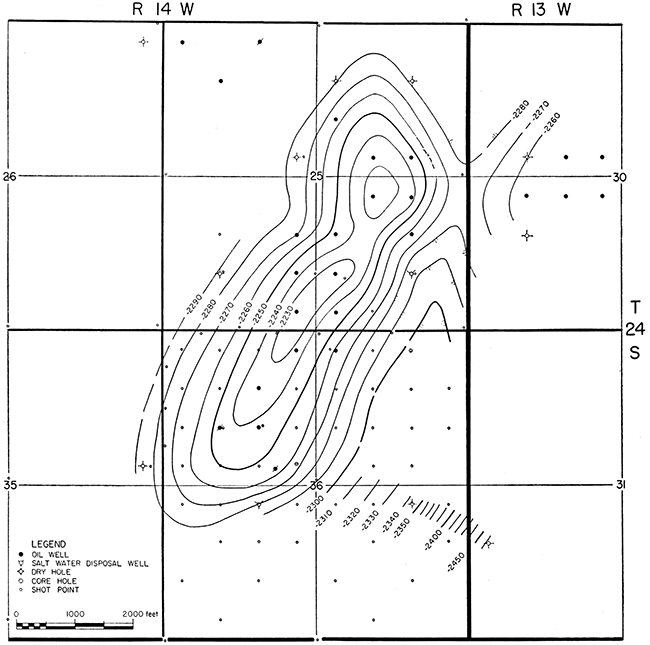
Figure 6--Conventional seismic structure map, pre-Pennsylvanian. Contour interval 2 milliseconds.
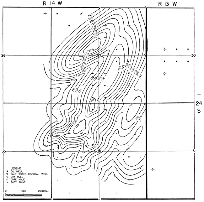
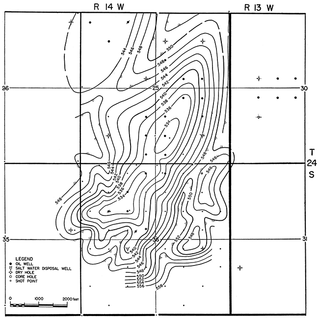
Figures 7 and 8 compare structure on top of the Lansing limestone as mapped from well data with a conventional seismic structure map of the Lansing. Figure 7, the Lansing subsurface structural map, reveals a southwestward-plunging feature aligned north northeast. The structural crest is displaced slightly from the crest on the top of the Arbuckle, and the amount of closure is slightly less, somewhat more than 30 feet. Figure 8, the conventional seismic structural map of the Lansing, discloses the axis of the main feature in the correct position, but shows many of the same irregularities, a result of erratic near-surface velocity variations. The feature centering around the dry hole in the SE SE SW sec. 25 is not so prominent. This is generally a fairly reliable map, but mis-ties are of the same magnitude and in the same places as on the seismic pre-Pennsylvanian map. Mis-ties on the order of 30 feet may be observed between offset wells.
Figure 7--Subsurface structure map, top of Lansing limestone. Contour interval 10 feet.
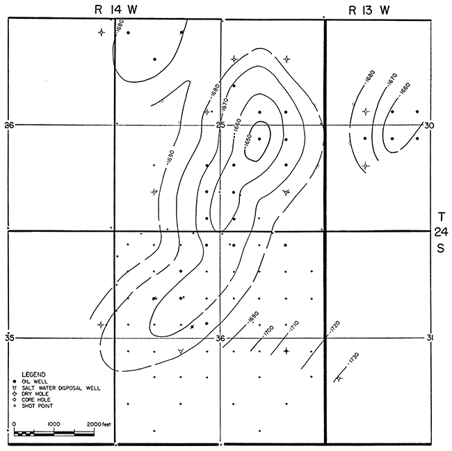
Figure 8--Conventional seismic structure map, Lansing limestone. Contour interval 2 milliseconds.
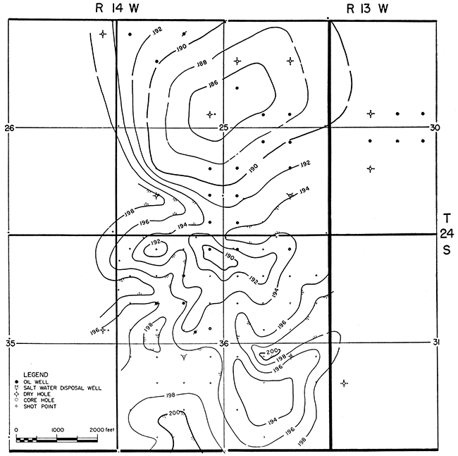
Figures 9 and 10 compare a structural map of the Stone Corral anhydrite based on well data with a conventional seismic structural map on the Stone Corral. The subsurface structural map, Figure 9, shows a broad flat feature having a general northsouth axis and approximately 10 feet of closure. The highest point structurally is around the dry hole in the SE SE NW sec. 25. Southwestward dip may be observed across the southwestern portion of the field. The conventional seismic structural map, Figure 10, reveals a very irregular broad feature, of which the high point is near the SE SE NW sec. 25. The many irregularities are principally a result of erratic velocity variations above the Stone Corral. The anomaly centering around the dry hole in the SE SE SW sec. 25 completely overshadows the actual structural anomaly. As will be seen later, seismic isochron maps rectify this situation. Mis-ties are on the order of 15 to 20 feet.
Figure 9--Subsurface structure map, top of Stone Corral anhydrite. Contour interval 10 feet.
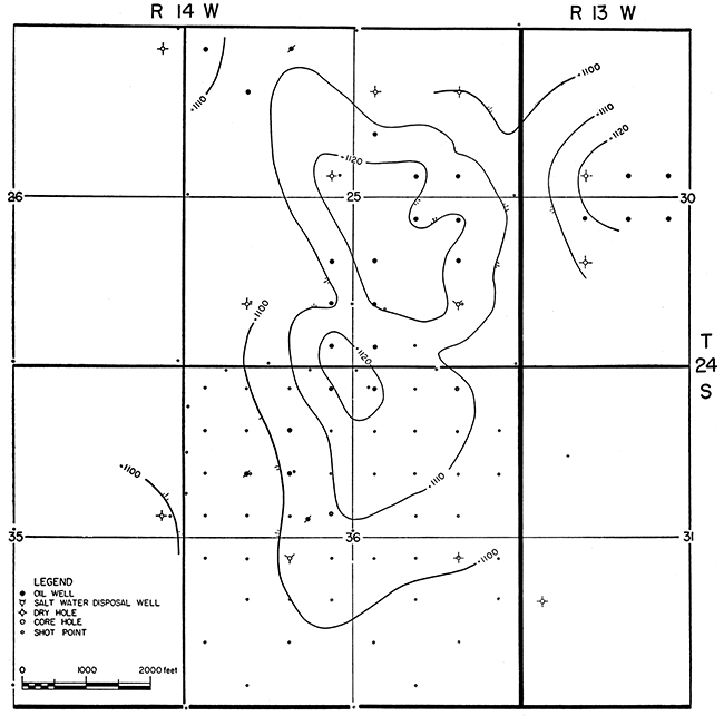
Figure 10--Conventional seismic structure map, Stone Corral anhydrite. Contour interval 2 milliseconds.
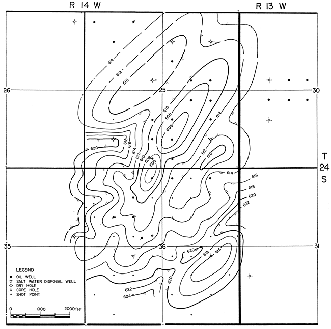
The next comparisons are between subsurface isopachous and seismic isochron maps. The close comparison is readily apparent, as is the comparison of the seismic isochron maps and the subsurface structural maps of the top of the Lansing and the Arbuckle. Various features assume their proper relationship and proportion.
Figures 11 and 12 compare a subsurface isopachous map of the beds from the Stone Corral anhydrite to the Arbuckle dolomite and an isochron map of the interval from the Stone Corral to the pre-Pennsylvanian from seismic record data. The isopachous map, Figure 11, shows the trend and plunge of the feature and reveals marked thinning and eastward divergence. Figure 12, the isochron map, compares very well with the isopachous map. Better correspondence would have resulted if there had been more detail points at the northern end of the structure, but general shape and relationship agreement is good. Mis-ties are on the order of 20 feet or less, and seem to be a result of a slight southward gradient in the interval velocities. The small subsidiary features east of the main axis should be noted. The actual Stone Corral anhydrite data from a core hole and a dry hole show that these anomalies are too low structurally to afford production.
Figure 11--Isopachous map, Stone Corral to Arbuckle, based on well data. Contour interval 10 feet.
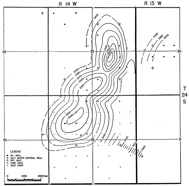
Figure 12--Isochron map, Stone Corral to pre-Pennsylvanian, from seismic records. Contour interval 2 milliseconds.
The comparison between isopachous and seismic isochron maps of the interval between the Stone Corral anhydrite and Lansing may be observed on Figures 13 and 14. The close correspondence is readily seen despite the irregularities on the isochron map, which result from the close seismic control over the southern portion of the feature. The greatest mis-tie between the data is on the order of 20 feet from north to south. The field would have been found readily from the isochron map.
Figure 13--Isopachous map, Stone Corral to Lansing, based on well data. Contour interval 10 feet.
Figure 14--Isochron map, Stone Corral to Lansing, from seismic records. Contour interval 2 milliseconds.
The remarkably close comparison of the seismic isochron maps with both the isopachous and subsurface structural maps is evident. The distortion of the conventional seismic structural maps at several important points is caused by near-surface velocity variations. The isochron studies restore relationships to their proper proportions. Critical examination of all of these data would have prevented the drilling of the original dry hole in the SE SE SW sec. 25 and would have allowed location of a test hole at the proper position so that oil would have been discovered. A core hole drilled to the Stone Corral anhydrite in the NW NE NE sec. 36 provided an actual Stone Corral anhydrite point from which seismic data could be projected to the Arbuckle. Because the Arbuckle was evidently too low structurally to be productive this small subsidiary feature had no economic importance.
All wells in the Koelsch Southeast pool have been drilled with rotary tools. The most common practice is to drill through the unconsolidated material to a depth of 200 feet and set a protective string of 8 5/8-inch casing, but in several wells 8 5/8-inch casing was set in the Stone Corral anhydrite at approximately 800 feet. This latter practice was followed because of the possibility of corrosive water in Comanchean rocks. Setting the longer string of surface casing and cementing to the surface provides maximum protection to the oil string. In most wells, after the top of the Arbuckle was reached, drill-stem test run, and the hole drilled to a point below the water level, which was originally at a subsea datum of approximately 2,270 feet, the production string of 5 1/2-inch casing was cemented and the well completed through perforations. Most of the wells were completed without acid treatment of the Arbuckle. Treatment of a few wells was necessary. The amount of acid used ranged from 500 to 2,000 gallons.
Porosity in the Arbuckle in this field is primarily from fractures. Oil is of high gravity and is difficult to detect in cuttings, which accounts for the fact that the Armer No. 1 Mackley was plugged as a dry hole. The character of the reservoir was not fully understood during the development of the field, and many wells were perforated too near water level. Inasmuch as the reservoir is under strong water drive and wells were initially produced above the optimum rate, premature water encroachment resulted.
Several wells in the field were completed by setting casing at the top of the Arbuckle after minor penetration with the rotary bit and were drilled in with cable tools, with minimum penetration of the formation. Had all wells been completed with minimum penetration, been perforated near the top of the formation and produced at a lower rate, water encroachment would not have been so rapid.
All gas is in solution and the oil is undersaturated; consequently, all wells were pumped from the beginning of production. Salt water produced with the oil is injected into the lower part of the Arbuckle or the Precambrian through disposal wells.
During the seismic survey, about eight holes were shot per day at an average cost of $65 to $70 each. The cost of the reconnaissance survey is estimated at approximately $1,500. Cost of the reconnaissance and subsequent detailing involving a total of 74 shot points is estimated at $5,000. Average cost per acre for the 640 acres leased by the operators was approximately $8.00.
Average cost of a completed producing well in the field ranged from $40,000 to $45,000. Dry holes cost approximately $17,500. Cumulative production of oil from the field prior to January 1, 1957, was 459,036 barrels.
Twenty eight oil discoveries of varying degrees of importance, including Koelsch Southeast, were made in the area of nine townships covered in the original reconnaissance survey. Several other discoveries have been made by other operators on anomalies outlined during the course of the survey. Several prospects remain to be tested.
The "anhydrite reference plane" method is no universal panacea for all seismic problems in western Kansas, and it has certain disadvantages, which have been pointed out. Nevertheless, it is the best technique that has been developed thus far for outlining the small structures that may afford production in certain portions of western Kansas. The general technique may be applied in many areas in and outside of Kansas, where shallow reflections can be obtained from good subsurface markers, where the economic limit of conventional seismic work has been reached, and where small structures are productive of oil. Obviously, good records are a necessity and ample subsurface control must be available. A reference plane must be relatively flat locally and not influenced by strong regional dip. The most important factor, of course, is the economics of such surveys. Are the costs justified by the anticipated return from oil discovery?
The application of this technique, and the close cooperation and coordin~tion of experienced geologists and geophysicists, coupled with diligent effort and understanding of each other's problems, will produce unusually good results.
The writer expresses his appreciation to his former partners in Manhart, Millison, and Beebe, and to the management of Natural Gas and Oil Corporation for permission to publish this paper.
Beebe, B. W., and Ballou, A. L., Jr. (1956) A case history of the Smallwood Pool, Stafford County, Kansas: Geophysical Case Histories, v. 2, Soc. Explor. Geophys., p. 310-327.
Imbt, W. C. (1941) Zenith Pool, Stafford County, Kansas-an example of stratigraphic trap accumulation: Stratigraphic Type Oil Fields, Am. Assoc. Petroleum Geologists Bull., v. 25, p.139-165.
Latta, Bruce F. (1950) Geology and ground-water resources of Barton and Stafford Counties, Kansas: Kansas Geol. Survey, Bull. 88, p. 1-228. [available online]
Kansas Geological Survey
Comments to webadmin@kgs.ku.edu
Web version Dec. 10, 2013. Original publication date 1959.
URL=http://www.kgs.ku.edu/Publications/Bulletins/137/Beebe/index.html