 |
An Atlas of the Kansas High Plains AquiferJeffrey A. Schloss, Robert W. Buddemeier, and Blake B. Wilson, eds.Educational Series 142000 92 pages, 39 figures, glossary, and reading list |
| A full online version of this publication is not available. Copies of this publication are available from the publications office of the Kansas Geological Survey (785-864-3965). The cost is $15.00 per copy, plus sales tax, shipping, and handling. |
This atlas focuses on ground water and related water-resource issues in the High Plains aquifer in western and central Kansas. This region of the state largely depends on ground-water resources, which are, for the most part, fully appropriated and are declining in a number of areas. The western two-thirds of the state contrasts with eastern Kansas where precipitation and streamflow are more abundant, and the principal aquifer resources generally consist of alluvial deposits that have direct hydrologic connections to the streams. In eastern Kansas there generally is less stress on and competition for ground-water resources. In comparison, the High Plains aquifer of western and central Kansas encompasses a much larger area and contains a greater volume of ground water, much of which occurs independent of current streamflows. Due to the more arid environment, lack of dependable streamflow, and greater accessibility to ground water, a large proportion of the water-right development in Kansas has occurred within the High Plains aquifer region. The High Plains aquifer region has an integrated agribusiness system based primarily on irrigation, and depends on ground-water resources which, for the most part, are nonrenewable under current water-use conditions. Kansas water policy and management practices thus must encompass a variety of environmental, economic, and hydrologic issues, of which meeting the water needs of western and central Kansas is among the most challenging.
The primary audience for this atlas is therefore the community of policy-makers, managers, and their technical support staff. At the same time, this information will be useful and of interest to both the general public and to researchers and analysts. To make the presentation as useful and authoritative as possible, it has been organized in a basic pattern of brief summary presentations of the various topics and results, accompanied by illustrative maps or figures. A standard format has been adopted that addresses for each topic:
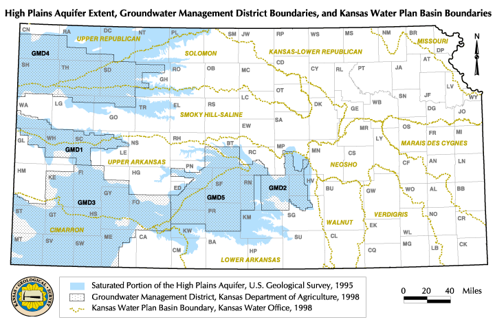
| Figure 1. Map of High Plains Aquifer Extent, Groundwater Management District Boundaries, and Kansas Water Plan Basin Boundaries |
 |
This book is a published version of an online project: http://www.kgs.ku.edu/HighPlains/atlas/index.html.