 |
|
Kansas Geological Survey Open-file Report 2003-82 |
1.3 Area of Investigation
The study area covers approximately 4,000 square miles (approximately 10,300 sq km) within an eight-county area in southeastern Kansas (Figure 1.03). It includes all of Cherokee, Crawford, Neosho, Labette, Wilson, Montgomery, Elk and Chautauqua counties. Cherokee Group rocks are present in the subsurface throughout most of the study area and crop out in a northeast-southwest-trending belt along the southeastern edge of the study area. For over 145 years coal deposits of eastern Kansas have been mined with a total production of approximately 300 million short tons (272 million metric tons; Brady, 1997). During this time major peaks in production corresponded with World War I and II (Brady, 1997). For the past 25 years coal production has followed a steady decline due to low commodity prices and the demand for higher quality coal from other regions.
1.4 Previous Investigations
Previous studies have dealt with the stratigraphy and distribution of coal
beds or sandstones within the Cherokee Group (Abernathy, 1936; Searight et
al, 1953; Howe, 1956; Branson, 1957; and Searight and Howe, 1961). The first
reference to the Cherokee Group concerned outcrops along the banks of the
Neosho River in southeastern Kansas (Haworth and Kirk, 1894). Subsequently,
the Cherokee Group was subdivided into fifteen cyclothems (Abernathy, 1936).
Howe (1956) subdivided the Cherokee Group from the top of one coal bed to
the next overlying coal bed and designated these units as formations. These
earlier works, supplemented by the work of others, were the basis of the current
accepted stratigraphic classification (Jewett et al., 1968; Figure 1.01).
Previous work on the Cherokee Group centered on the major sandstones that
formed the traditional “shoestring” oil reservoirs of southeastern
Kansas and northeastern Oklahoma.
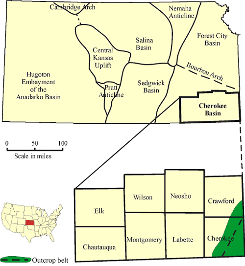 |
| Figure 1.03 - Location of study area in state of Kansas |
Recent studies have focused on the stratigraphy and/or depositional environments of the Cherokee Group relating to strippable coal reserves, and conventional sandstone petroleum reservoirs. Early work calculated the strippable coal reserves of eastern Kansas (Brady et al., 1976), while more recent work involved the first identification of coalbed methane resources (Brady, 1990, 1997). Harris (1984) examined the Krebs Formation in southeastern Kansas, and described the stratigraphy and depositional environments. Staton (1987) completed a similar study for all of the Cherokee Group in the central Cherokee basin. Walton (1995) applied sequence stratigraphic concepts to the Cherokee Group, and identified twenty-two sequence boundaries, of which some have a regional extent while others are only considered to be local. This study overlaps the areas of both Staton (1987) and Harris (1984). However, the focus is on coal deposits as a nonconventional gas reservoir, whereas previous work was centered on major sandstone deposits of the Cherokee Group (Figure 1.04).
Interpretation of depositional environments for units of the Cherokee Group (primarily sandstone deposits) have evolved and changed many times since the original interpretations (Bass, 1934). Bass (1934) concluded that the major “shoestring” sandstones were deposited in offshore barrier-bar environments. Following this interpretation, Hayes (1963) re-interpreted the sandstone units that crop out in Missouri as tidal-flat or tidal channel environments based on the presence of bi-directional cross-bedding. Cole (1969), and Visher et al. (1971) interpret most of the Cherokee Group sandstones to be fluvial-deltaic environments.
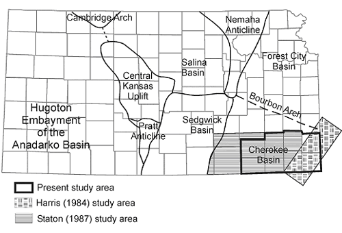 |
| Figure 1.04 - Location of study area in relation to the study area of Harris (1984) and Staton(1987), and to the major structural features of Kansas. |
e-mail : webadmin@kgs.ku.edu
Last updated January 2004
http://www.kgs.ku.edu/PRS/publication/2003/ofr2003-82/chapter1-3.html