In a series of papers during the 80's John Doveton and Dave Collins of the Kansas Geological Survey proposed a color image transformation that achieves a significant improvement in the stratigraphic interpretation of wireline log data. When well designed, such a transformation of wireline log data from multiple wells can maximize both spatial and compositional information contents, and provide a readily interpretable image of the subsurface geology. They introduced the concept of a color cube subdivided into a series of discrete cells to represent the log data. The planes between cells were selected to coincide with coordinate values that discriminate between lithologies, porosity levels, or shale mineralogy. The transformation operates as an automatic classification device that provides visual meaning. The color image transformation was used to construct single well displays, and a single cross-section across western Kansas. The cross-section was constructed on a well-by-well basis, and resembles in many ways a standard 2D seismic display (See Doveton, 1994, Geologic Log Analysis Using Computer Methods, AAPG Computer Applications in Geology 2, p. 43).
We use a similar transform of a single curve or combination from multiple tools (e.g., gamma ray, density and neutron) to generate a color coded "crossplot log" for each well as the single trace input to the pseudo-seismic approach. The key is to take the transformed log data and treat it as either 2D or 3D "seismic" data. The actual conversion of digitized well data to pseudo-seismic data is accomplished by a conversion program to transform wire-line or transformed wireline log data into a binary SEGY file. The program "maps" the well header information into the SEGY header and the well data into the SEGY data field. Trace spacing can be determined from well spacing based on the nearest neighbors to an arbitrary spacing unit (e.g., an 80 acre bin or a 330 foot spacing). Transformation of well locations to trace spacing can be computed rounding to the nearest hole spacing unit or bin. Areas without wells can be represented by empty bins or blank traces.
Treating well data as pseudo-seismic data eases the data handling burden. As an example, a traditional well log cross-section that contains 200 wells is difficult to construct, to interpret, and to visualize because of physical size required for visualization. In contrast, seismic lines with less than 200 traces are atypical due to difficulty of interpretation and visualization from such a small data set. As discussed in the introduction, a comprehensive analysis of a 3-D set of well logs encompassing the more than 12,000 wells of the Hugoton Embayment would be a nearly intractable problem. Typical 3-D seismic surveys also have dense data: on the order of thousands of traces per square mile and tens of square miles in extent. A single fully developed county in the Hugoton embayment of southwest Kansas contains roughly the same number of data points (wells) as one square mile of 3-D seismic. In terms of data density, the 15 counties of southwest Kansas and the 12,000 wells are roughly analogous to a 15 square mile 3-D seismic survey. Treating well log data as seismic data could render a comprehensive analysis of a large mature field or basin tractable. The transformed wireline log data can be loaded into a computer workstation and interpreted as a 3D "pseudo-seismic" volume. Using a seismic approach to well data can significantly ease the data handling burdens through use of computerized techniques designed for interpretation and display of seismic data. The use of interpretation and processing packages developed for seismic data offers flexibility in displaying and picking horizons, and opens new opportunities for increasing the efficiency of stratigraphic interpretation. The change in approach from the traditional well-by-well examination to treating the wireline logs in a field or basin as a data volume permits comprehensive study and cost effective analysis of data sets that were previously considered intractable.
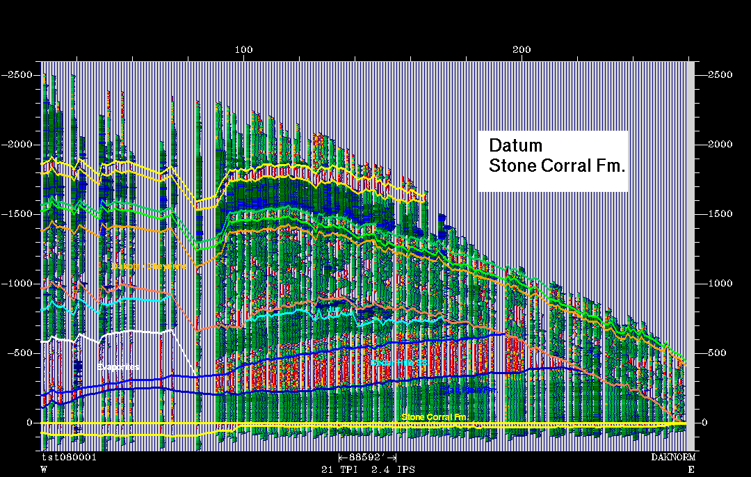
The attached gray-level example of a pseudo-seismic line mimics in part the east-west regional section constructed on a well-by-well basis by Collins and Doveton. The Permian Stone Corral Formation is used as a stratigraphic datum. Color displays of several different versions of this pseudo-seismic line, along with a copy of the text are available through the World Wide Web on the Kansas Geologic Survey's server. The attached pseudo-seismic line is a simple representation of Permian through Cretaceous rocks of western Kansas based solely on the gamma-ray logs. However even this simple representation shows the power of pseudo-seismic approach. The 200+ wells were converted to SEGY format and loaded into Seisworks as traces. Trace spacing was selected to be approximately one mile, and wells were assigned to the nearest trace. Areas of sparse well control are represented by blank traces. The section can be interpreted and displayed using all the tools available within Seisworks. Using just the rudimentary Seisworks tools, the results were startling in terms of an increase in interpretation speed. Using the zoom, datum, and manual and auto-picking tools, the line was interpreted in matter of few hours. In addition, interpretations could be subject to continuous verification by examination of the data set as a whole. The display capability of Seisworks increases the power of the visualization as compared to traditional computer assisted wireline log cross-sections. Features such as truncation of individual beds within the Permian by the base Cretaceous unconformity (white horizon), the effect of dissolution of Permian salt on localizing deposition of overlying basal Cretaceous fluvial sands, and normal faulting on the western margin of the Central Kansas Uplift are readily apparent. The zoom and datum capability of Seisworks can be used to map truncation, onlap, and downlap of individual "beds" within specific stratigraphic units. In terms of vertical resolution pseudo-seismic data can surpass seismic data. Vertical resolution is only limited by the resolution of the logging tool and of the digital data.