Processing of pseudo-seismic well data like seismic data could result in a better understanding of the rock record. We are investigating the utility of various operations such as AGC, filtering, wavelet convolution, spectral analysis, and attribute analysis. These "en masse" trace/well operations are nothing new to seismic data, but represent a new dimension in petrophysical analysis. Processing the pseudo-seismic data may, in some cases, help the interpreter to identify trends in the data set, and emphasize different aspects of the subsurface geology. Filtering and wavelet convolution (the act of convolving a wavelet with a reflectivity series) may help to smear or average the pseudo-seismic data set, aiding in identifying particular lithologic zones in an overall mixed succession (e.g., sand-filled channels or carbonate shoals). In a general sense this is comparable to the geologist stepping back from the outcrop and squinting to get a better perspective. If used with caution and adequate geologic control, these processes may do much to increase our understanding of basin evolution. John Hopkins has begun to use Landmark's Batch-Control-Monitor-2D (bcm2d) software to investigate the utility of these operations on the pseudo-seismic data.
We are also using a 3X3X3 color cube to crossplot apparent grain density (RHOmaa), apparent volumetric photoelectric absorption (Umaa) and gamma ray log values along with the pseudo-seismic approach to develop a detailed understanding of lateral variations in thin bedded sequences of carbonates, shales and sandstones. Similar crossploting techniques are being investigated as tools to display lateral variations in a large number of reservoir parameters (e.g., porosity, bulk water volume, and apparent salinity).
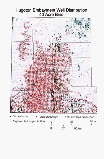
Our most ambitious undertaking to date is to undertake a comprehensive study of the important Permian gas reservoirs in the Hugoton embayment of southwest Kansas using a 3-D pseudo-seismic approach. The Hugoton Embayment is an ideal candidate for 3-D pseudo-seismic analysis of stratigraphic and reservoir variability in the three dimensions. It has a large number of wells with suites of modern wireline logs drilled at an average of greater than two per section over an area of approximately 12,000 square miles. The combination of high well density, subtle structure, even spacing, and modern logs results in a high-quality wireline log 3-D data volume that approximates a seismic grid with a rather large bin size (160 to 320 acre bins). In addition, the Hugoton and associated gas fields are an important asset to Kansas and the nation. The Hugoton field alone produces nearly 500 Bcf/year.
Other applications of the pseudo-seismic approach have been proposed and include: using sonic logs to create synthetic seismic section and to map regional velocity functions; and using the interpolation tools of Seisworks to model missing pseudo-traces/wells.