Conclusions
The final results of the project are inconclusive but suggest that high
resolution acquisition of seismic data at the frequencies needed to accurately
identify relatively thin Morrow sandstones versus shales near the top of
channels incised into Mississippian limestones may be difficult to impossible.
However, due to the environmental problems faced during this survey, this
does not mean that it will be impossible for another survey during a dry
period to identify sands versus shales using changes in seismic attributes.
Such a survey might test various sources such as deeper wells with a larger
Pentalite dynamite source, or a survey which uses a different source such
as a high-frequency vibrator prior to acquisition. This survey though, was
only able to identify channels, and general channel thicknesses based on
amplitude and isochron anomalies. The only possible seismic signatures due
to sand versus no sand are found on line 3 (Fig.
27) where a channel anomaly that contains sand has a lower amplitude
than one that is slightly thicker and contains no sand, and on Line 1 (Fig. 23) where a channel anomaly associated with
a thicker channel with productive sandstone has about the same amplitude
as an area which has no sand, but it thinner and was expected to have a
lower amplitude anomaly. These characteristics, however do not seem to be
consistent throughout the data set, and should not be trusted to predict
sandstone thickness. In addition, at the vertical resolution possible with
this data set, any change in seismic character due to changes in sandstone
thickness, would probably be overwhelmed by the overall changes in thickness
of the Morrow to Mississippian clastic section.
If future experiments are done to determine if it is possible to identify
the productive Morrow sandstones in this area, they should only be done
on a small scale, during dry weather, with a different source, source depth,
and/or charge size, with a system that has a large dynamic range, and with
the expectation that a lot of 60 and 120 Hz electronic noise will be in
the area. Alternatively, since the thickest, most productive sandstones
appear to occur above the channels (though productive sandstones do not
occur above all the channels), and since increasing amounts of 2-D seismic
data point to increasing complexity in the channels, a 3-D seismic survey
may go a long way towards mapping out the true position and connectivity
of the channels, and identifying their thickness with reflection amplitude.
This may aid in finding places where thick sandstones could occur but have
been overlooked, and may also aid in determining how the productive sandstones
penetrated in the various wells in the fields are connected. However, unless
higher frequencies than those acquired in this experiment are recorded at
the Morrow-Mississippian clastic interval, identification of sandstone versus
shale is remote, and dry holes are still possible.
One final, specific conclusion that can be drawn from this experiment
is the modification of the seismic anomaly channel map. Channel margins
determined from seismic anomalies visible on this data set have been added
to those determined from previous seismic data (Fig.
28).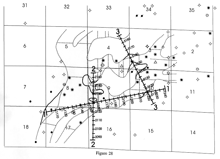 This new map adds to the observation
that some of the channels are fairly sinuous, that intrachannel highs with
thin Morrow-Mississippian clastic sections do occur, and that the channel
margin in sections 8 and 17 may be farther west than previously mapped.
Although not indicated on the map in Figure 28,
the seismic data collected during this experiment could also be used to
map the thickness of the Morrow-Mississippian clastic section using the
seismic amplitudes and isochron thickness variations of the peaks above
and below the top of the Morrow.
This new map adds to the observation
that some of the channels are fairly sinuous, that intrachannel highs with
thin Morrow-Mississippian clastic sections do occur, and that the channel
margin in sections 8 and 17 may be farther west than previously mapped.
Although not indicated on the map in Figure 28,
the seismic data collected during this experiment could also be used to
map the thickness of the Morrow-Mississippian clastic section using the
seismic amplitudes and isochron thickness variations of the peaks above
and below the top of the Morrow.
The broader implications of this experiment suggest that extreme care
must be take when acquiring high-resolution seismic data over an existing
field in an area with a large amount of cultural noise such as power lines
and other sources of electronic noise. Moisture in the cable, if only in
small amounts, can be a great detriment to acquiring signal above 60 Hz
if sources of electrical noise are present in the area. Notch filters, either
during acquisition or processing may help reduce or eliminate the noise,
but at a cost of phase shifts and frequency holes in the data that can be
severe enough to make stratigraphic interpretations extremely difficult.
Spectral balancing and deconvolution can help, but will not boost higher
frequency signal if it is not there or is of extremely low amplitude compared
to the noise. Also, this experiment suggests that loess may not be the best
place to set of shots since it appears to soak up a lot of higher frequency
energy.
e-mail : webadmin@kgs.ku.edu
Updated January 1999
The URL for this page is http://www.kgs.ku.edu/PRS/publication/OFR98_44/conclusions.html