Kansas Geological Survey, Open-file Report 2004-39
Index of Images || Small Web Image || Acrobat PDF (665K)
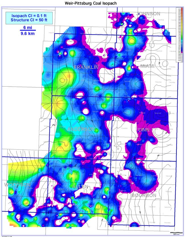
The Weir-Pittsburg coal exhibits a lenticular coal-seam geometry. Orientation of the coal seam is interpreted to parallel depositional dip (southwest). The Weir-Pittsburg coal is extensive over an estimated 3,327 sq mi and continuous over 1,201 sq mi (8,617 and 3,111 sq km [36.1%], respectively). Coal thickness in the Bourbon arch ranges from 0 to 3.5 ft (0 to 1.1 m), averaging 0.8 ft (0.2 m). Trends of thick Weir-Pittsburg coal occur in the western portion of the study area (Woodson, western Franklin, and Anderson counties). The coal pinches out eastward into Johnson, Miami, Linn, and Bourbon counties. No distinct relationship is exists when the Weir-Pittsburg coal isopach is superimposed on the coal's basal structural contours; thicker coal isopach values are associated with localized structural highs and lows throughout the area. On a regional scale, the Weir-Pittsburg coal is thicker in the western portion of the study area and pinches out to the east and northeast (Miami, Linn, and Bourbon counties). The coal isopach generally parallels underlying structure contours across the Bourbon arch. In addition to nondeposition, the absence of coal may also be due to channel incision from the overlying Chelsea Sandstone Member.