
Stratigraphic Elements
Natural gamma-ray logs from 59 of the vent and observation wells and 57 nearby oil wells and gas-storage wells were used to conduct high-resolution stratigraphic correlation and mapping of 15 closely spaced marker beds within the Lower Permian strata for a 150-mi2 area encompassing Hutchinson and Yaggy (Nissen and Watney, 2003; Watney et al., 2003). The logs were normalized so that units range from 0 (salt) to 100 (shale).
The main gas-bearing interval generally corresponds to a characteristic pattern of three low natural gamma-ray lobes, informally referred to as the “3-finger dolomite,” which can be correlated throughout the Hutchinson area. In several wells, gas is found in an interval approximately 5 to 10 feet below the base of the 3-finger dolomite, corresponding to a fourth low gamma-ray lobe, designated 3A. This lobe appears to be discontinuous and cannot be mapped throughout the Hutchinson area. Deeper gas zones have been reported in two vent wells. The high-pressure gas vented from DDV #64 in July 2001originated from a zone 70 ft below the top of the 3-finger dolomite, corresponding to marker bed M1A. Gas in DDV #09 (approximately 1,000 ft to the north of dry hole DDV #45) was reported from an interval 37 ft below the top of the 3-finger dolomite, corresponding to marker bed M1.
Top 3-Finger Dolomite Structure
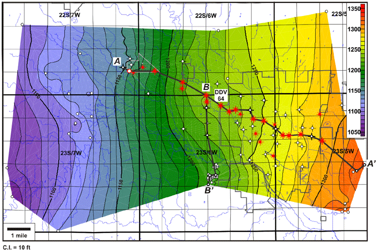
A structure map of the top 3-finger dolomite shows a regional westerly structural dip of approximately 20 ft/mi. To the west of Hutchinson, a broad, west-northwest-trending anticline (the Yaggy-Hutchinson anticline) is superimposed on this regional dip. Gas-producing vent wells lie along the northern edge of this anticline. DDV #64 is located on a closed high along the crest of the anticline. This may have made DDV #64 a focus for gas migration.


Click on above images for greater detail
Last updated June 2004
http://www.kgs.ku.edu/PRS/publication/2004/AAPG/NG_Migration/P1-03.html