
Geologic Factors Controlling Natural Gas Distribution
Related to the January 2001 Gas Explosions
in Hutchinson, Kansas
Susan E. Nissen, W. Lynn Watney, Saibal Bhattacharya,
Alan P. Byrnes, and David Young
Open-File Report 2004-21
Open-File Report 2004-21
Abstract
In January 2001, explosions and eruptions of gas geysers occurred in the city of Hutchinson, Kansas. Three days earlier, an estimated 143 million cu ft of natural gas at high pressure escaped from a casing leak at the Yaggy underground gas storage facility, 7 miles to the northwest. At Yaggy, natural gas was stored in solution caverns in the Lower Permian Hutchinson Salt Member. The casing leak was located just below the top of the salt and 184 ft above the top of the storage cavern. Vent and observation wells drilled in the area after the explosions encountered gas over a distance of 9 miles, primarily along a narrow, northwest-southeast-trending corridor between Yaggy and eastern Hutchinson. The widespread distribution of gas warranted further characterization of the surrounding geology to resolve features that provided pathways for the gas. Studies of 116 borehole logs in a 150 mi2 area, along with seismic lines, core, well logs, and shut-in pressure data, suggest that gas moved through the area within a thin dolomite interval 170 ft above the top of the Hutchinson Salt Member, apparently along a fracture cluster that follows the crest of a low-relief, westerly plunging anticline. High-resolution seismic and stratigraphic analyses revealed deep-seated structural features that appear to have controlled fracture and fault concentrations in the thin, brittle dolomite beds that served as the conduits for the gas. Episodes of focused undersaturated ground-water circulation along associated fractures apparently resulted in evaporite dissolution that enhanced structural relief and tensional forces along the anticline.
Background
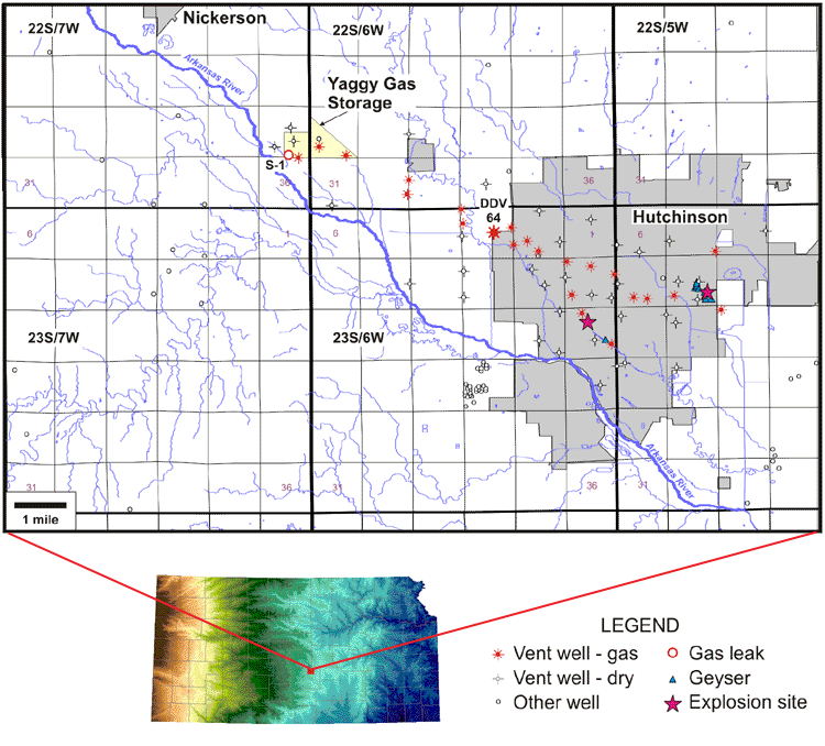
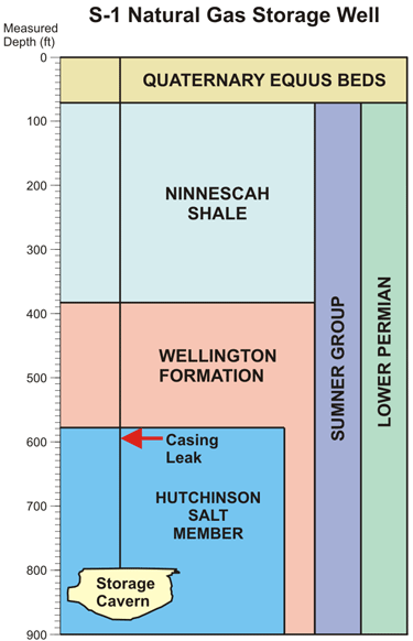
On January 17 and 18, 2001, explosions and eruptions of gas geysers occurred in the city of Hutchinson, Kansas. Three days earlier, natural gas at high pressure (600+ psi) began escaping from a casing leak in a natural gas storage well, S-1, at the Yaggy underground gas storage facility, 7 miles to the northwest of Hutchinson, with an estimated loss of 143 million cu ft of gas. At Yaggy, natural gas is stored at depths in excess of 600 ft in solution-mined caverns in the Hutchinson Salt Member of the Lower Permian Wellington Formation of the Sumner Group. The casing leak was located just below the top of the salt and 184 ft above the top of the storage cavern.
 |
In response to the explosions, 57 vent wells and five observation
wells were drilled in the city of Hutchinson and westward towards the
Yaggy storage facility. These wells detected gas over a distance of 9
miles, primarily along a narrow, northwest-southeast-trending corridor
between Yaggy and eastern Hutchinson. For all but two of the productive
vent wells, the gas was contained within a 30-ft thick interval approximately
170 ft above the top of the Hutchinson Salt Member, which core data show
to contain several thin dolomite layers. The natural gas that caused the
explosions and gas geysers reached the surface from this interval through
abandoned brine wells. On July 7, 2001, DDV #64, in T23S R6W Sec. 3, suddenly
vented large amounts of gas at high pressure over several days. This gas
originated from a zone 70 ft below the main gas-bearing interval.
The widespread lateral distribution of gas, along with its apparent narrow vertical distribution, warranted further characterization of the surrounding geology to resolve features that provided pathways for gas movement. |
http://www.kgs.ku.edu/PRS/publication/2004/AAPG/NG_Migration/P1-02.html