Case Study - Minneola Field Complex
Clark County, Kansas, Pennsylvanian, Atoka/Morrow Incised Valley Fill Sandstone Utilitizing Log and Core Petrophysics, Volumetrics
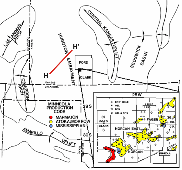
West central Midcontinent showing location of Minneola field complex (from Kruger,1996)
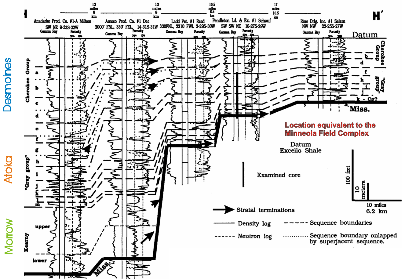
Regional SW-NE cross section Lower to Middle Pennsylvanian from east-central Seward County to northeast through Gray County (see index above) (from Youle, 1992)
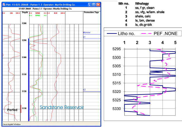
Composite well log with stratigraphic units and core description with Pe curve for Patton 1-3
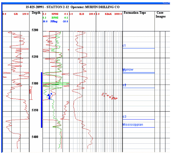
Cored well Statton 2-12 with reservoir sandstone. Cored interval shown by core analyses points. Perforations shown as red circles in depth column. DST interval is also shown in the depth track.
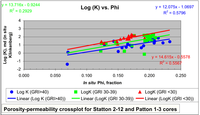
Scatter in the porosity-permeability relationship reduced when samples were classified by shale content proxied by gamma ray (API units). Higher permeability was noted in cleaner sandstones, thus Vsh, shale fraction, was recognized as important in delineating favorable lithofacies and prospective hydrocarbon pay.
Depth profile of S2 cycle showing sandstone pay
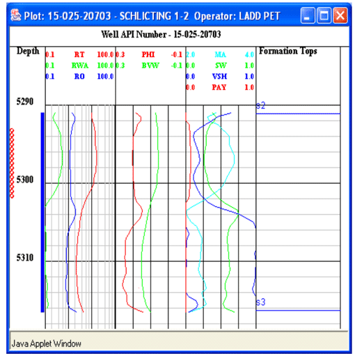
Log analysis was conducted on the S2 sandstone reservoir to define effective pay. The Schlicting 1-2 lease produced a billion cubic feet of gas. The S2 sandstone is thick and clean. Well profile shows lobe of sand with Vsh curve and high porosity. Well perforations are also shown. Alongside the log profile is the lease production history showing annual and cumulative. Cut-offs include Vsh = 30%, Phi = 12%, Sw = 50%, and BVW = 0.12.
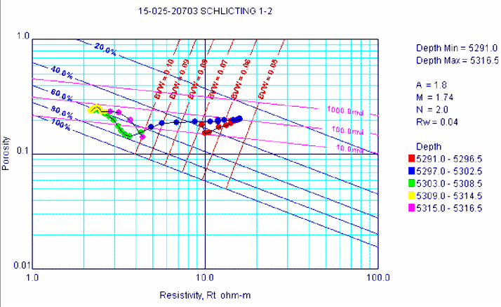
Super Pickett crossplot of Schlicting #1-2 well. Low BVW (high phi and low Sw) combine to describe a good hydrocarbon pay zone that has produced over a BCF of natural gas.
Click on the above image to show greater detail
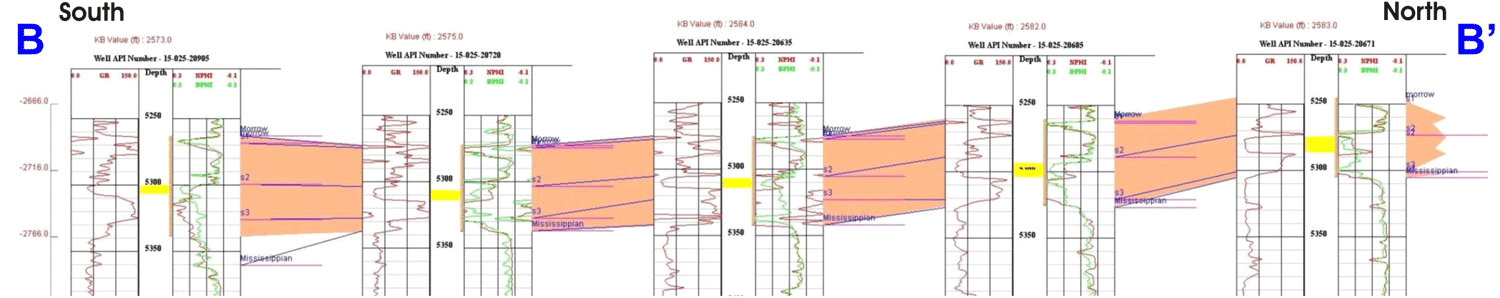
South-to-North structure cross section B-B' highlighting Morrow interval with S1, S2 and S3 cycles. Yellow bar in depth track highlights the porous sandstone reservoir in the S2 cycle that was identified in core and log analysis. Sandstone cleanest to north with lower gamma ray and higher porosity.
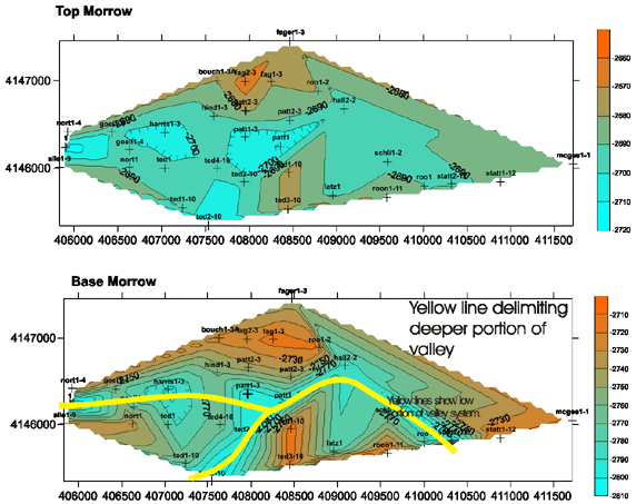
Structure maps (sealevel datum) for the datum at the top and base of the Morrow
The top of the Morrow interval in the incised valley in Norcan East is a current-day structural low higher to the east and deeper to the west. The elevation at the base of the Morrow clearly delimits the incised valley with a deeper axis extending from the southeast up to the central area and then through a narrow constricted part of the valley then southwestward forming an L-shaped pattern.
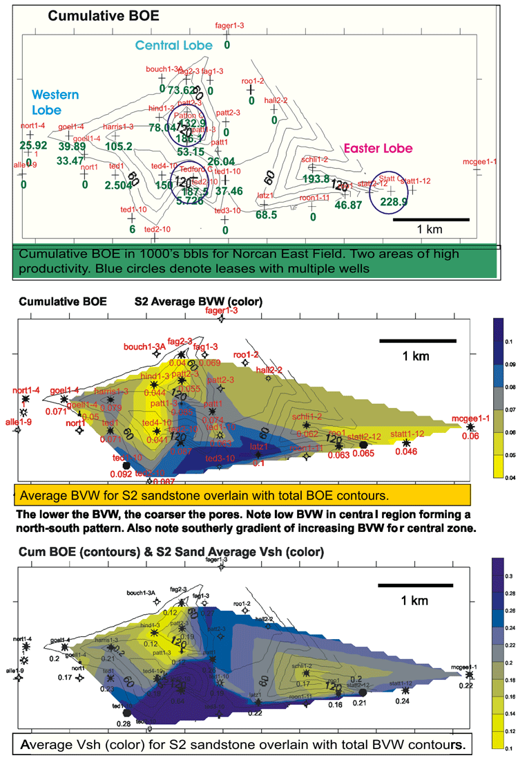
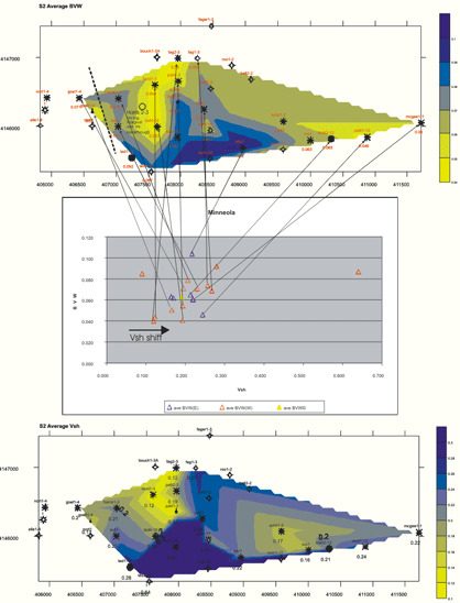
The central lobe is cleanest (low Vsh) in the north-central and gradually increases to the southwest. Similarly, the Vsh declines to the northwest. The locus of highly productive areas (CUM BOE Overlay) closely corresponds to these lobes of cleaner sandstone and it is inferred that the lobes reflect depositional features, low Vsh closest to the source of the sand. Based on comparison of productive and dry wells, the Vsh cut-off was confirmed to be 0.3.
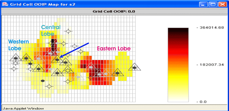
The original-oil-in-place shows two distinctive lobes. The injection well, also the cored well, Patton #1-3 (denoted by the blue arrow) is located in the middle of the field. The location of the injector is not optimum in terms of sand quality or hydrocarbon pore volume. Any realignment of the waterflood would include reversing the low pressure regime through large water volume needed just to fill up the pore space and regain elevated pressures. Also, loss of solution gas pressure and occupancy of free gas in the pore space will block oil movement from some areas and make incremental oil recovery expensive and difficult. Reservoir simulation will utilize the new volumetric parameters to examine further options for improving oil recovery.
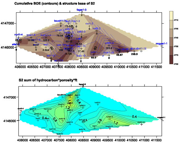
Comparisons of total BOE and So*phi*ft and elevation base of S2 cycle
 |
|
Reservoir Geology of Minneola Field Complex
A possible source of sand supplying the central lobe of sandstone appears to have been from the north where the reservoir properties gradually improve. The inferred proximal source of the southeastern lobe of sand appears to be from the southeastern edge of the valley. Lithofacies suggests that the fluvial channel sand was increasingly modified by marine and tidal influences more distal from the source (northwest).
A stillstand in sealevel and prolonged shoreline at and near this location probably led to sand accumulation in a partially filled, incised valley system (also interpreted as barrier sands by Clark, 1986).
The quartz sand closely resembles the sandy matrix of the underlying Mississippian Ste. Genevieve Limestone into which the incised valley was developed. The sealevel stillstand may also have been responsible for transported products of the weathered limestone, i.e., sandstone, to sites of lower energy such as local fall lines in bays and estuaries such as the valley would provide. This limited sand accumulation is suggestive of local sand supply, rather than a large tributary drainage system. Moreover, the western limit of the S2 cycle sand in Norcan East Field grades to limestone confirmed in cores obtained within a mile southwest of the field (Wears #1 in Section 8-30S-25W and Harris #1 in Section 9-30S-25W). This suggests that marine shelf equivalents to the clastics are carbonate deposits.
Continuing collaborative studies will further refine the geo-engineering model in the Minneola area. Small oil and gas operators have the opportunity to conduct similar studies of their reservoirs leveraging public-domain databases and employing new recovery technologies at reduced risks.
References for Minneola field complex:
Bhattacharya, S., Byrnes, A.P., Gerlach, P., Olea, R., 2002, Reservoir Characterization to Inexpensively Evaluate the Exploitation Potential of a Small Morrow Incised Valley-fill Field, Kansas Geological Survey, Open-file Report 2002-9 http://www.kgs.ku.edu/PRS/Poster/2002/2002-9/P1-02.html
Clark, S.L, 1987, Seismic stratigraphy of early Pennsylvanian Morrowan sandstones, Minneola Complex, Ford and Clark Counties, Kansas: American Association of Petroleum Geologists, Bulletin, v.71, p.1329-1341.
Clark, S.L., 1995, Minneola Complex, Ford and Clark Counties, Kansas, in Anderson, N.L., and Hedke, D.E., eds., Geophysical Atlas of Selected Oil and Gas Fields in Kansas: Kansas Geological Survey, Bulletin 237, p.95-98.
Kruger, J.M., 1996, Seismic modeling in Minneola Complex, Ford and Clark Counties, Kansas: Differentialing thin-bedded Morrow sandstones from shale in lower Pennsylvanian channel fill, Kansas Geological Survey, Open-file Report 96-50 http://www.kgs.ku.edu/PRS/publication/OFR98_44/f2index.html
Youle, J.C.; Watney, W.L.; and Lambert, L.L., 1994, Stratial hierarchy and sequence stratigraphy: Middle Pennsylvanian, southwestern Kansas, U.S.A., In, Klein, G.D., (ed); Pangea; paleoclimate, tectonics, and sedimentation during accretion, zenith, and breakup of a supercontinent, Geological Society of America, Special Paper, no. 288, pp.267-285.
Montgomery, S.L., 1996, Stewart field, Finney County, Kansas; seismic definition and thin channel reservoirs: American Association of Petroleum Geologists, Bulletin, vol. 80, no 12, pp.p. 1833-1844.
Youle, J.C., 1992, Sequence stratigraphy of the Lower Middle Pennsylvanian and distribution of selected sandstones, eastern Hugoton embayment, southwestern Kansas: Unpubl. M.S. thesis, Department of Geology, University of Kansas, Lawrence, KS, 202p. (avail as Kansas Geological Survey, Open-file Report no. 92-55).
http://www.kgs.ku.edu/PRS/publication/2004/AAPG/GEMINI/p3-07.html
Last Modified October 2004