 |
Southwest Kansas |
Kansas Geological Survey Open-file Report 2003-30 |
Statement of Problem
-
No comprehensive geologic model for the Council Grove available.
-
Accurate reservoir model is critical for most efficient management of remaining resources in this large asset.
-
Lithofacies controlled petrophysical properties dictate gas saturations.
-
Accurate discrimination of lithofacies reduces error in predicted permeability and gas volume.
-
The Council Grove is a large, complex heterogeneous reservoir.
-
Field-wide upscaling of lithofacies distribution for reservoir characterization and analysis of large heterogeneous reservoirs like the Panoma Field is impractical by traditional methods
Solution
Use artificial intelligence to predict lithofacies in 500 wells and fill a 3D volume with lithofacies constrained porosity, permeability and gas saturations.
- Identify and characterize key lithofacies and tie to core petrophysical
properties. - Predict lithofacies for wells without cores using a neural net and electric log curves and marine-nonmarine indicator curve as predictor variables. Generate predicted lithofacies and probability curves.
- Fill 3-D cellular volume with lithofacies and porosity using Petrel.
- Add lithofacies-constrained permeability and gas saturations to cell properties with transform formulas and height above free water.
- Export cellular model with porosity, permeability, and initial gas saturations to a reservoir simulator.
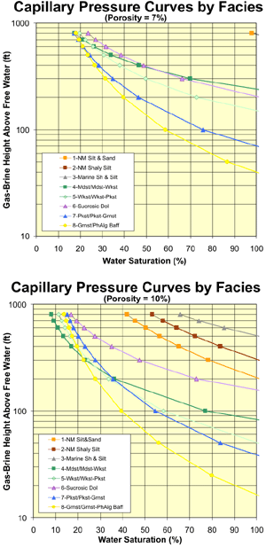 |
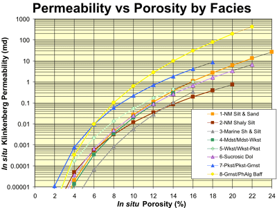
Council Grove facies identification is important to reservoir characterization because petrophysical properties vary between facies. At porosities > 6% permeability in grainstone/bafflestones can be 30X greater than mudstones and >100X greater than marine siltstones of similar porosity. Differences in permeabilities between nonmarine silt/sandstones and shaly siltstones range from 3.3X at 12% porosity to 7X at 18%. Capillary pressures and corresponding
water saturations also vary between facies. For example, at 7% porosity
(which represents >50% of all Mstn/Wkstn) at 200 ft above free water
Mudstones are 100% water saturated while grainstones exhibit water saturations
of |
|
|
|
e-mail : webadmin@kgs.ku.edu
Last updated May 2003
http://www.kgs.ku.edu/PRS/publication/2003/ofr2003-30/P1-08.html