
|
Reservoir Characterization to Inexpensively Evaluate
the Exploitation Potential of a Small Morrow Incised Valley-fill
Field
|

Kansas Geological Survey
Open-file Report 2002-9 |
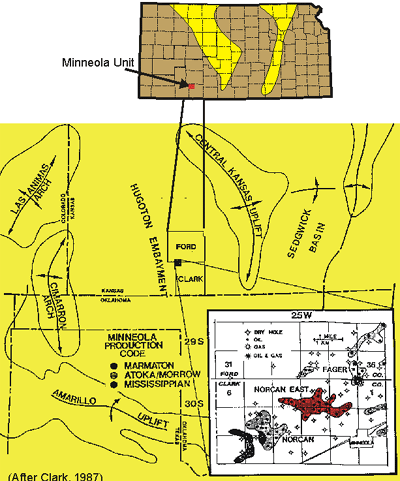
Norcan East Field, Minneola Unit
Clark County, Kansas
Setting and History
The Norcan East Field, part of the Minneola Unit, is located
in Clark County, Kansas, approximately one mile north and two
miles west of Minneola, Kansas. Initial development in this area
began with the drilling of Norton #1-8 in Section 8, T30S, R25W.
Completed in September 1980, this well initially flowed 157 bopd
and 120 mcfd. Murfin Drilling Co. began active drilling in 1983.
Effective July 1993, Murfin Drilling purchased all of Swift Energy's
(successor to Ladd Petroleum) interest in the general area. Figure
1 shows the boundary of the Minneola unit along with the well
locations, well names, and corresponding unit numbers.
The Minneola Unit produces from the Morrow sandstone. Based
on production and simulation the reservoir drive mechanism is
primarily solution-gas drive. Initial oil production varied from
38 to 164 bopd with many wells producing associated gas. DST analyses
showed that wells completed in the early half of 1983 averaged
an initial reservoir pressure of 1,555 psi while those completed
in 1985 averaged 817 psi. This is consistent with production from
a solution-gas drive reservoir without pressure support resulting
in a rapid decline of reservoir pressure. By 1993, the wells in
the unitized area were approaching their economic limit under
primary production, with field production having dropped to 26
bopd. In 1994, 13 tracts, operated by Murfin Drilling Co., were
unitized to initiate a water-flooding program. The unitized area
covers about 1040 acres and includes the W/2 of the NE/4, and
the S/2 of section 3; the S/2 of section 4; and the N/2 of section
10; all in T30S-R25W, Clark County, Kansas. Included in the unitized
area are 12 producing wells and 2 water injection wells. This
project focused on the unitized area and included the surrounding
area (Figure 1) to develop a 3D geomodel that formed the basis
for reservoir simulation.
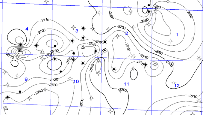
Subsea structure map on the top of the Morrow
e-mail : webadmin@kgs.ku.edu
Last updated March 2002
http://www.kgs.ku.edu/PRS/Poster/2002/2002-9/P1-09.html