
|
Reservoir Characterization to Inexpensively Evaluate
the Exploitation Potential of a Small Morrow Incised Valley-fill
Field
|

Kansas Geological Survey
Open-file Report 2002-9 |
Morrow Incised Valley-Fill System in Kansas
Facies Assemblage
Morrow Sandstone facies assemblages are consistent with the
wave-dominated tripartite model for IVF systems proposed by Dalrymple
et al. (1992) and presented by Allen and Posamentier (1994, Figure)
comprising; (1) a marine sand plug formed at the seaward, high
wave energy end of the valley (estuary mouth), (2) a low-energy
middle zone, characterized by fine-grained deposition (central
bay), and (3) a high-energy inner zone dominated by the discharge
of fluvial tributaries (bay-head delta or upper estuary channels).
Local evidence of tide-dominance is also evident. Within the
Morrow of SW Kansas, Buatois et al. (1999) identified fifteen
facies grouped into estuarine and marine assemblages. Core (Figure)
from the J.M. Huber Kendrick #23-1 (Sec. 23, T. 29 S., R. 41 W.;
5375-5460 ft) presents a complete transgressive sequence from
basal conglomerates overlying the lowstand erosion surface through
fluvial channel sandstones, central bay muds, estuary mouth marine
sandstones, to open marine shales.
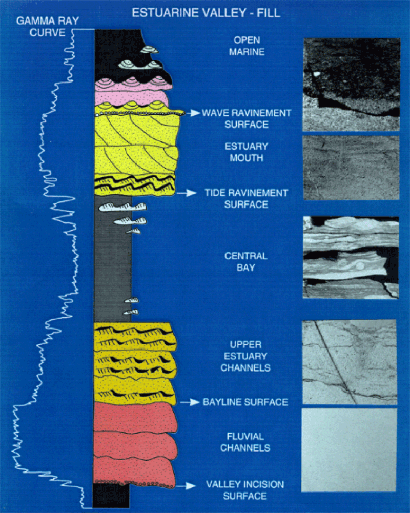
(From Buatois et al., 1999)
Facies and Reservoir Rock Properties
Using the faceis classification of Buatois et al. (1999) Morrow
Sandstone estuarine and marine lithofacies generally exhibit unique
suites of petrophysical properties. In general, facies exhibiting
good reservoir properties with high porosity and permeability
and low Swi include fluvial (facies A), upper estuary channel
(facies C), and upper shoreface (facies I) sandstones. Facies
exhibiting marginal reservoir properties with lower porosity and
permeability, and Swi greater than 50% include estuary mouth (facies
H), restricted tidal flat (facies E), and middle shoreface deposits
(facies J). Non-reservoir facies, with low porosity and permeability
and Swi greater than 80% include nonmarine paleosols (facies B),
central estuarine bay shales (facies D), restricted tidal flat
facies (E), tidal channel (facies F), and lower estuary mudstones
(facies G); and marine lower shoreface (facies K and L ) and deeper
water deposits (facies M, N, and O).
e-mail : webadmin@kgs.ku.edu
Last updated March 2002
http://www.kgs.ku.edu/PRS/Poster/2002/2002-9/P1-08.html