
Seismic Detection of Shallow Natural Gas Beneath Hutchinson, Kansas
Kansas Geological Survey
Open-file Report 2002-44
|
|
|
Kansas Geological Survey Open-file Report 2002-44 |
On January 17-18, 2001, a series of natural gas explosions and geysers occurred in the city of Hutchinson, Kansas, killing two people, destroying several buildings, and causing the evacuation of dozens of businesses and several hundred households. The source of this gas appears to have been the Yaggy gas storage field, 7 miles northwest of the city, which experienced a leak two days prior to the explosions at Hutchinson.
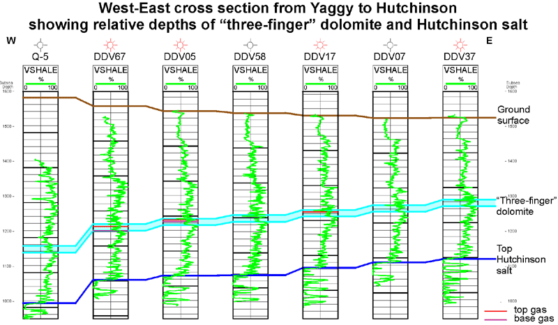
At Yaggy, natural gas is stored at depths greater than 500 ft in caverns in the Hutchinson Salt Member of the Permian Wellington Formation. A casing failure was discovered in the well accessing one of these caverns, and this failure could have allowed high-pressure gas to leak from the cavern. After an initial high-pressure gas release around the storage site, the gas appears to have traveled updip toward Hutchinson along have traveled updip toward Hutchinson along previously unknown conduits. A series of wells were drilled in and around Hutchinson to find and vent remaining underground gas to the surface.
The gas-bearing interval appears to be confined to a zone approximately 150 ft above the Hutchinson salt, which core data shows to contain several thin dolomite layers. These dolomites can be correlated on gamma ray logs from the vent wells, and the zone has been labeled the “three-finger” dolomite. The thickness of the “three-finger” dolomite is relatively uniform throughout the area, at approximately 20 ft thick. The gamma ray signature of the “three-finger” dolomite in the vent wells indicates that this zone increases in shaliness to the north.
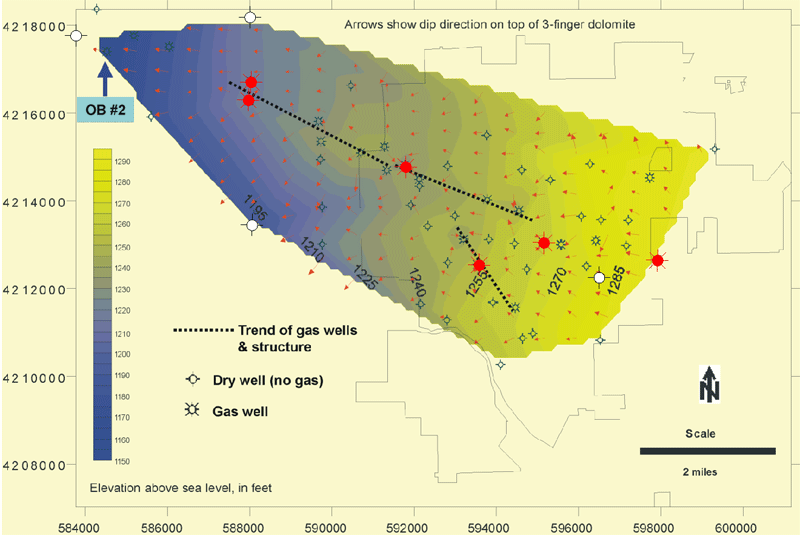
Locations of gas-producing vent wells between the Yaggy storage field and the city of Hutchinson correspond closely to the crest of a narrow, asymmetric, northwest-plunging anticline, as can be seen in the structure map of the “three-finger” dolomite. Maps of shut-in pressure in gas wells calculated at the depth of the gas zone also indicate a correlation between higher gas pressures and crestal areas of the anticline (Bhattacharya and Watney, 2001).

Configuration of top "Three Finger" dolomite
|
|
|