| Kansas Geological Survey Open-File Report |
Index of Images || Small Web Image || Large Web Image || Acrobat PDF (14.4 Megs)
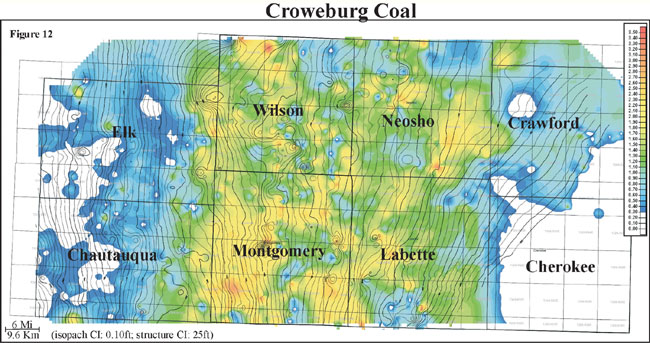
Isopach mapping of the Croweburg coal reveals a laterally continuous coal that has a consistency in thickness over an average of 6 miles (9.6 km). Thickness of the Croweburg coal ranges from 0 to 3 feet with an average of 1 foot and has a normal distribution (0 to 0.9 m, average of 0.3 m). The Croweburg coal exhibits a lenticular geometry that is oriented parallel to depositional dip and strike. As consistent with many of the other coals, structure appears to influence coal thickness. When overlaying structural contours of bottom of the Croweburg coal onto an isopach of Croweburg coal thickness, the coal appears to thicken on highs and thin into lows. The Croweburg coal is consistently thicker in Wilson, Montgomery, Neosho, and Labette counties. Localized thin areas and trends within the thicker Croweburg coal may be due to removal by fire or crevasse splays.