1998 Annual Water Level Raw Data Report for Kansas
Prev Page--Spatial Quality Control || Next Page--Conclusions
John C. Davis and Ricardo Olea, Mathematical Geology Section
The original observation well network was intended to be a regular hexagonal pattern, with observation wells located at or near the centers of the hexagons (Figure 1). This pattern is based on theoretical work done by R.A. Olea (1982, 1984), who demonstrated that such a sampling pattern was the most efficient for characterizing a spatially distributed property such as the water table elevation. It is "most efficient" in the sense that the hexagonal pattern requires the fewest number of observations to estimate a surface to within a specified level of uncertainty. Any other pattern of observations will either have greater uncertainty or will require more points. Based on the rate of lateral change in water table elevation as a function of the distance between observation wells, Olea (1982) determined the cell size for a regular hexag-onal network over the High Plains Aquifer whose average uncertainty (standard error of estimate) would be less than 12 feet; each hexagon would encompass approximately 16 square miles.
Figure 1. Regular face-centered hexagonal pattern of observation wells.
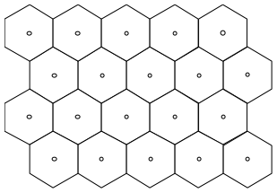
Figure 2. Stratified hexagonal sampling network for observation wells.
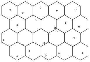
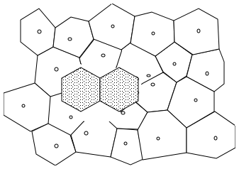
One way of analyzing the seriousness of gaps that are the result of unfortunate local placement of observation wells within hexagons is to consider each well as though it were located at the center of an irregular polygon. These irregular polygons (called Voronoi polyhedrons or Teissen polygons) are calculated so that every point within a polygon is closer to the observation well at its center than the point is to any other observation well. The wells from the stratified hexagonal network of Figure 2 are shown within a set of such polygons in Figure 3. The two shaded regular hexagons represent empty cells that would fit within the irregular network, demonstrating that the network contains an inadequately sampled gap.
Figure 3. Irregular polygonal network of observation wells from
Figure 2, showing unsampled gap (shaded hexagons).
Unfortunately, such geostatistical studies take time and may delay the measurement of replacement wells. Sometimes field crews discover that an observation well is no longer suitable for measurement and must be dropped from the network. If a replacement well could be chosen and measured immediately, while the crew is still in the field, the cost of sending people back into the field could be avoided. However, simply choosing the nearest well as the replacement for an abandoned observation well may make a gap in the network even worse. A good rule of thumb for field workers to use for selecting a replacement for a lost observation well is to choose a new well that is as close as possible to the center of the hexagon containing the lost well. Choosing a replacement well near the center of the hexagon will result in better network coverage than simply replacing the lost well with a nearby well.
References
Olea, R.A., 1982, Optimization of the High Plains aquifer observation network, Kansas: Kansas Geological Survey, Ground Water Series No. 7, Lawrence, KS, 73 p.
Olea, R.A., 1984, Sampling design optimization for spatial functions: Mathematical Geology, v. 16, no. 4, p. 369-392.
Prev Page--Spatial Quality Control || Next Page--Conclusions