Acquisition Activity, Statistical Quality Control, and Spatial Quality Control for 1997 Annual Water Level Data Acquired by the Kansas Geological Survey
Prev Page--Summary || Next Page--Statistical Quality Control Measurements
The current acquisition methodology is well established and has been in use for the last 40 years. To some degree the measurement technique has been unchanged for several decades, as dictated by physical limitations both at the surface and within the casing of wells that make up the network. Most measurements are taken in irrigation wells where access is limited by both surface and downhole pumping equipment (Figure 2). Abandoned wells and some livestock wells also provide a challenge to measure since, when properly maintained, they will have a semi-permanent seal on top the casing (welded plate, locked cap, etc.) (Figures 3, 4, and 5). Access to the piezometric surface in most measured wells is through access tubes, threaded plug holes, or open slits in the wellhead base with no possibility for direct vertical access through any kind of removable well head or cap (Figures 6 and 7). These small openings (generally <1") are in the side of the well head or in access tubes or slant pipes through the well curb/pad (Figures 8 and 9). In many cases the measuring device must make a 90-degree bend to get parallel to the well bore at or near the ground surface. For some well installations several access points are available, but for consistency reasons measurements are only made through a particular opening.
The water level measurements are taken with a steel tape lowered down the well bore assisted by a lead weight attached to the end of the tape by a copper wire (Figure 10). The lead weight serves two purposes: first, it minimizes the effects of tape coil down hole; and second, if the lead weight and copper get hung up and lost down hole it will not (at least not to date) interfere with the operation of an irrigation water pump (generally turbine type). A steel tape used for measurements in southwestern Kansas needs to be capable of reaching depths of over 400 ft. Steel tapes are annotated with both raised marking indicating feet, tenths of feet, and hundredths of feet between the end of the tape and the 30 ft mark, and with embedded plates displaying length in one-foot intervals from the 30 ft mark to 500 ft (end of tape).
Measurements are taken by coating the lower 15 ft or so of the tape with carpenter's chalk (generally blue) (Figure 11). The tape and end weight are coaxed through small access ports and generally around a corner and then slowly alongside any casing and pump in the well bore down to a predetermined depth (Figure 12). The stop depth (length of tape in hole) or tape hold is established based on previous years' water level values and measured drop in the current year's water level in nearby wells. Once the appropriate depth is reached and the tape has hung in the hole for a second or two, the tape is retrieved. Once the portion of the tape is reached with annotations in tenths of feet, the chalked surface is carefully examined to establish the location of the "cut." The cut is the line below which the chalk has been washed away by water standing in the well (Figure 13). The cut represents the water level or piezometric surface depth from the measurement point. The quality of the cut is then qualitatively established. The cut can be sharp with no indications of wash-off or moisture above the cut, and in such a case it would be considered an excellent to good measurement. The cut can also be very difficult to determine due to everything from cascading water within the borehole to casing moisture contacted by the tape during placement or extraction. If the measurer is confident a good reading has been made, the tape hold and cut line are recorded and used to calculate depth from ground surface to the top of water.
An important in-field appraisal of confidence in a water level measurement requires differencing of the previous year's water level with the current measured level to establish a water table drop or rise. This water level change is then compared to the local trend established in close proximity wells. If, in the judgment of the field staff, the relative difference between the current year and previous year's measurements is reasonably small, the value is logged, considered a good reading, and the well is tagged. If a low confidence value or an off-trend reading is determined, a second measurement is made. This process continues until a reliable reading is obtained.
Each well measured is tagged with a color-coded Tyvek tag attached to the well with a wire tie. The tag identifies the measurement participants (i.e., Kansas Geological Survey and the Division of Water Resources) and well statistics. It documents the well location, landowner's name, measuring agency, downhole access, obstructions, cut quality, oil on water, remarks, surface and measurement point access, depth to water, date, and initials of measurer. The tag also displays the KGS address and phone if inquiries are necessary. The tagging is the last operation to take place at the well prior to proceeding to the next well location.
All measurements and observations are recorded the daily field log books. These log books are transcribed into a digital file within a few days on weeks of the actual measurements. These digital data are then provided to the Geohydrology staff at the KGS on or around February 1 for tabulation, collation, and inclusion in the annually published water level report.
1997 Acquisition Activity
A field crew from the KGS acquired data from 562 wells in 17 western Kansas counties during January 1997 (Figure 14). The measurement technique and overall responsibilities associated with the 1997 annual water level measurement program were completely consistent with previous years when the KGS sponsored acquisition activities through the U.S. Geological Survey (USGS) field office formerly in Garden City, Kansas (Miller, 1996). Data acquisition was broken into three field periods with the first (primary) extending from January 2 to January 11, the second running from January 21 to January 25, and the third including March 5 and 6. During the primary acquisition phase each well was visited and appropriate data were taken. The second outing was designed to acquire Quality Assurance (QA) data and complete necessary Quality Control (QC) re-visits. The third and final trip of 1997 was intended to acquire a second set of QA data and to reacquire previously questionable or missing GPS data. All raw data acquired (with the exception of the third acquisition trip) by the KGS on the annual water level measurement program were compiled, digitally stored, and circulated to the appropriate agencies, groups, and individuals in their raw, unprocessed form (digital and/or analog) on or about February 1, 1997. This section represents a summary of all the raw data, acquisition activities, and technique development.
Figure 14--Counties in Water Level Measurement Program measured
in 1997 by KGS.
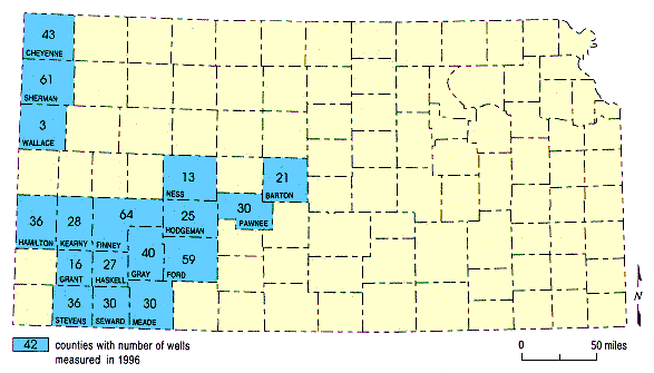
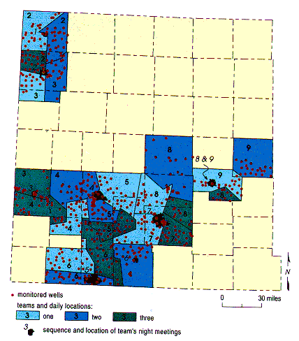
Figure 15--Annual water level wells measured by KGS divided into route
and team responsibilities.
QA/QC
The first QC trip was completed in four days by two people. The QC water level remeasures covered 14 counties, included 72 wells, and were completed during the second trip (first QC trip) (Figure 16). The QC trip was to verify out-of-trend measurements and to acquire missing well data. This QC re-visit resulted in confirmation or successful measurement of 62 wells previously unmeasurable or out-of-trend. Final measurements at these 62 wells took an average of nearly two hours per well and as a group were situated along routes that required a total of about 4,160 miles of vehicle travel. These 72 wells were selected after careful examination of primary trip measurements; a well was remeasured if it met any one of the following criteria:
Figure 16--Quality control guidelines flagged 72 wells for revisits to
confirm or obtain missing measurements.
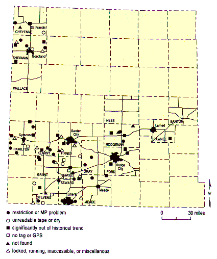
Figure 17--Quality assurance revisits to wells measured during primary
trip to establish repeatability.
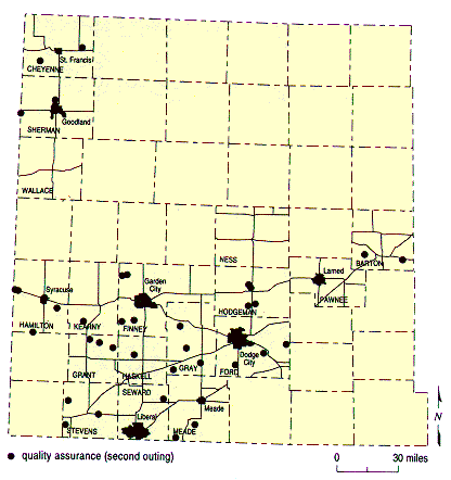
Figure 18--Quality assurance trip to acquire a third data set for purposes
of measurement consistency analysis.
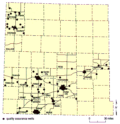
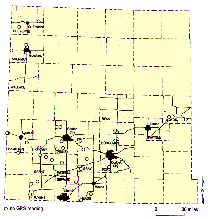
Figure 19--GPS Measurements were acquired at wells missing measurements
from primary trip or were more more than 400 m from current documented USGS location.
Well and Measurement Point Information
As part of the KGS portion of the annual measurement program, a few of the more significant well characteristics have been compiled for incorporation into future efforts to improve and maximize information obtained from the network.
| Wells Measured in 1997 | |
|---|---|
| Type of Well | No. of Wells |
| Irrigation | 405 |
| Unused (monitor or abandoned) | 102 |
| Stock | 23 |
| Household | 8 |
| Water Access | No. of Wells |
| Slant pipe | 64 |
| Measurement tube | 21 |
| Access holes or pump base | 336 |
| Open casing | 114 |
| Flip-style covers | 23 |
| Depth to Water | No. of Wells |
| Less than 100 ft | 206 |
| 100 to 200 ft | 243 |
| 200 to 300 ft | 79 |
| More than 300 ft | 14 |
| Drill Depth of Well | No. of Wells |
| Unknown | 97 |
| Less than 100 ft | 85 |
| 100 to 200 ft | 89 |
| 200 to 300 ft | 128 |
| 300 to 400 ft | 91 |
| More than 400 ft | 72 |
| Measurement Characteristics | No. of Wells |
| Oil on the water | 85 (15%) |
| Difficult downhole access | 73 (14%) |
| Difficult measurement point access | 60 (11%) |
| Difficult measurement (restrictions, snags, catches) | 130 (24%) |
In-field confidence in a particular measurement was qualitatively determined through inspection of chalk cut while general accuracy was quantitatively appraised using historical and local trends. Remeasurement was necessary if the chalk cut did not allow a confident reading or if the depth to water was not within the anticipated range.
| Measurement Confidence | |
|---|---|
| Wells Measured | No. of Wells |
| Once | 446 |
| Twice | 73 |
| Three times | 17 |
| Four times | 6 |
| Total Measurements | No. of Measurements |
| During primary and QC trips | 763 |
| During QA trips | 84 |
| Measurements Judged | No. of Wells |
| Excellent | 341 |
| Good | 162 |
| Fair | 39 |
Network Continuity
An uninterrupted historical record is important in trend determination and analysis. Significant effort was made to acquire measurements in wells missing data from any one of the last three years.
| Measured in 1997 but not in | No. of Wells |
|---|---|
| 1996 | 38 |
| 1995 or 1996 | 11 |
| 1994, 1995, or 1996 | 1 |
| Measured in 1996 but not in 1997 | 12 |
An issue of importance for maintaining the long-term health and continuity of the network is the identification of wells needing replacements and immediate identification of acceptable replacements. A well replacement process would allow current spatial distributions to be maintained and improved. Based on acquisition difficulties, a total of 23 wells have been identified as strong candidates for replacement. Of the 23 wells in need of replacement, 11 were unmeasurable in 1997 but have recorded measurements in 1996. Nine of the remaining 12 have not been measured in at least the last two years. The remaining three were measured during 1997 but due to plugging or access difficulties will not be visited as part of the 1998 annual measurement program.
Unique to the 1997 measurement program was the recording of latitude and longitude using a handheld GPS unit and the photographing of each well site. A total of 542 GPS-determined latitudes and longitudes were recorded at wells measured during the 1997 campaign. Photographs of 512 wells will be used to provide a visual record for future measurements. Incorporation of the GPS system, detailed site comments, and photographs into a digital database will greatly enhance location certainty, well familiarity, and identification regardless of experience with a particular well. On-site information available digitally will include not only photographs, but also measurement subtleties, downhole dangers, environmental cautions, and other concerns/comments of previous measurers.
| Wells Requiring Replacement and Reason | |
|---|---|
| 03S 40W 09BAA | Measurement questionable. |
| 03S 42W 26CCD | Bad obstruction at ~170 ft. |
| 07S 41W 07BCB | Well sounder stuck in well. |
| 22S 24W 14BBC | Various restrictions. Cannot measure. |
| 22S 24W 16ADB | Collapsed well. |
| 22S 39W 03BBB | Dirt filled in up to ~181 ft. |
| 24S 32W 35DD | Pumping daily for Brookover Inc. |
| 24S 33W 22BCC | Reported by property manager to be cemented. |
| 26S 24W 32CBA | Cannot find. Referenced windmill is gone. |
| 26S 31W 36CAB | Dry well confirmed by landowner. |
| 27S 38W 23CBB | Took alternate well, cannot find 23CBB. |
| 28S 34W 15DAB | Dry well. No major obstructions. |
| 28S 35W 05BCC | Well plugged. Irrigation well 40 ft away, but with many restrictions, cannot measure. |
| 29S 32W 19CCC | Rex Brown's well. Too crooked to continue measuring. |
| 29S 32W 26CBB | Tape hung at 290 ft. Cannot get past obstruction. |
| 30S 29W 23CAD | Tape hangs at 200 ft and cannot get past. |
| 30S 31W 24BBC | Reported plugged by landowner. |
| 31S 32W 03DAD | Various restrictions; cannot measure. |
| 31S 34W 18BBB | Got measurement, but bad catches at 20 ft intervals. |
| 32S 38W 23BDD | Casing broken off. Well recently covered. |
| 32S 39W 02BBB | No blockage, no water, no measurement. |
| 33S 36W 26DDD | Dry, no measurement possible. |
| 33S 37W 23CDB | Cannot find. |
| Water Levels and GPS Measurements Taken in 1997 | ||||||
|---|---|---|---|---|---|---|
| Well Site Measurement | Primary Trip |
Trip #2 | Trip #3 | Total No. of Unique Measurements | ||
| QA | QC | QA | QC | |||
| Water levels | 512 | 48 | 62 | 18 | 542 | |
| GPS | 537 | 38 | 552 | |||
1997 Water Levels
A total of 542 of the 562 wells that make up the KGS portion of the 1997 annual water level measurement program have reliable depth-to-water levels reported in this document (Appendix A). Wells are grouped by county and then cataloged according to well ID (township, range, section system). The levels reported in Appendix A represent the most reliable measurement taken at that well during the annual measurement period. In some cases a single well may have as many as four recorded measurements (Miller et al., 1997). Determination of the best value was made by the field person(s) who measured the well. The best measurement on each well was based on quality of cut, difficulty reaching the hold line and retrieving the tape from below water level, pre-cut moisture, level of confidence that the tape was hanging unimpaired in the borehole, and accuracy of measurement point hold. Historical or local water level trends were not considered in making this judgment.
Direct comparison of primary measurements and the QA measurements reveals important information about the accuracy through repeatability of the database as a whole (Appendix B). In general, the time separation between the primary and first QA measurements is about 10 days to two weeks and six weeks to two months between the primary and second QA campaigns. This remeasure information along with parts of the primary data are integral to quality control discussions documented in subsequent sections of this report.
Data Acquisition Summary
In summary, this year's effort by the KGS staff to fully undertake the acquisition of water level measurements previously contracted to the Garden City field office of the USGS has met or exceeded most of our expectations. Based on preliminary analysis:
| Contractor | Cost/Well |
|---|---|
| 1997 KGS (actual) | $65 |
| 1997 KGS (equivalent*) | $31 |
| 1996 USGS | $69 |
*Equivalent product cost does not include amortization of equipment costs or extra program activities such as QA data acquisition or analysis.
References
Miller, R.D., 1996, The acquisition of annual water levels in Kansas sponsored through a cooperative agreement between the KGS and USGS: Kansas Geological Survey, Open-file Report 96-39.
Miller, R.D., J. Davis, D. Laflen, J. Siceloff, B. Bennett, M. Brohammer, and P. Acker, 1997, Acquisition activity and raw data report on 1997 annual water level measurements: Kansas Geological Survey's portion: Kansas Geological Survey, Open-file Report 97-11.
Woods, J.J., and J.A. Schloss, 1996, January 1996 Kansas water levels and data related to water-level changes: Kansas Geological Survey, Technical Series 9, 124 pp.
Prev Page--Summary || Next Page--Statistical Quality Control Measurements