| Small Set Contents | Meaning |
|---|---|
| USGS_ID | A unique well identifier assigned by the U.S. Geological Survey, based on the latitude and longitude of the well location. |
| COUNTY | County name where well is located. |
| TOWNSHIP | Township value of well. In Kansas, the townships range from 1 in the north to 35 in the south. See T-R Figure for additional information. |
| TOWNSHIP_DIRECTION | South, in Kansas. |
| RANGE | Range values are 1 to 42 West or 1 to 25 East, with 1 at the Sixth Principal Meridian. See T-R Figure for additional information. |
| RANGE_DIRECTION | Kansas is split into East and West ranges along the Sixth Principal Meridian, a north-south line that runs along the Washington-Republic county line in the north to slightly east of the center of Sumner County. See T-R Figure for additional information. |
| SECTION | Each township-range block is split into 36 sections. See Section Numbering Figure for additional information. |
| SPOT | Each section is split into quarters, designated by A, B, C, or D. The section is split a maximum of four times, listed from largest to smallest. See Spot Figure for additional information. |
| LONGITUDE | The longitude of the well, generated by GPS readings or converted from legal descriptions. |
| LATITUDE | The latitude of the well, generated by GPS readings or converted from legal descriptions. |
| WATER_LEVEL | The depth to water in feet found in the latest survey. Wells with readings taken are listed. If there are two values (standard and quality control) then two complete records are included. |
| MEASUREMENT_DATE | The date the measurement was taken. A few wells have two records because of quality checks. The date can be used to separate the values. |
| MEASUREMENT_TIME | The time the measurement was taken. |
| Large Set Contents | Meaning |
| USGS_ID | A unique well identifier assigned by the U.S. Geological Survey, based on the latitude and longitude of the well location. |
| COUNTY | County name where well is located. |
| TOWNSHIP | Township value of well. In Kansas, the townships range from 1 in the north to 35 in the south. See T-R Figure for additional information. |
| TOWNSHIP_DIRECTION | South, in Kansas. |
| RANGE | Range values are 1 to 42 West or 1 to 25 East, with 1 at the Sixth Principal Meridian. See T-R Figure for additional information. |
| RANGE_DIRECTION | Kansas is split into East and West ranges along the Sixth Principal Meridian, a north-south line that runs along the Washington-Republic county line in the north to slightly east of the center of Sumner County. See T-R Figure for additional information. |
| SECTION | Each township-range block is split into 36 sections. See Section Numbering Figure for additional information. |
| SPOT | Each section is split into quarters, designated by A, B, C, or D. The section is split a maximum of four times, listed from largest to smallest. See Spot Figure for additional information. |
| LONGITUDE | The longitude of the well, generated by GPS readings or converted from legal descriptions. |
| LATITUDE | The latitude of the well, generated by GPS readings or converted from legal descriptions. |
| RESTRICTION_NOTES | Contains information on depths where the measuring tape has gotten caught or hangs up. Based on previous measurement attempts. |
| WELL_ACCESS | Access to the well can be described as "Easy," "Hard," or "Unknown." |
| DOWNHOLE_ACCESS | The difficulty in actually getting the tape into the well for measuring can be described as "Easy," "Hard," or "Unknown." |
| MP_HEIGHT | |
| MP_DESCRIPTION | |
| TAPE_HOLD | The stop depth or tape hold is used to decide how much tape should be let down the well. This value is based on the previous years' values. |
| CHALK_CUT | The value on the steel tape at which the chalk has been washed away. |
| CHALK_CUT_QUALITY | The water level in the well is measured by where on the steel tape the chalk has been washed off. The chalk is washed off by the water standing in the well, but may also be washed off by water cascading in the well or by casing moisture encountered as the tape dropped in the well. The quality of the cut is made in the field to help in assessing the measurement's quality. Values of "Excellent", "Fair", "Good", and "Unknown" are allowed. |
| OIL_ON_WATER | If traces of oil are found on the measuring tape, it is noted in the data. |
| WATER_LEVEL | The depth to water in feet found in the latest survey. Wells with readings taken are listed. If there are two values (standard and quality control) then two complete records are included. |
| MEASUREMENT_DATE | The date the measurement was taken. A few wells have two records because of quality checks. The date can be used to separate the values. |
| MEASUREMENT_TIME | The time the measurement was taken. |
| INITIALS | The initials of the person responsible for taking the measurement. |
| AGENCY | The initials of the agency responsible for the measurement. "KGS" is Kansas Geological Survey, "DWR" is Division of Water Resources of the Kansas Department of Agriculture. |
| 2000_LEVEL | First level (in feet) from 2000 in database. |
| 1999_LEVEL | First level (in feet) from 1999 in database. |
| 1998_LEVEL | First level (in feet) from 1998 in database. |
| 1997_LEVEL | First level (in feet) from 1997 in database. |
| 1996_LEVEL | First level (in feet) from 1996 in database. |
| 1995_LEVEL | First level (in feet) from 1995 in database. |
| 1994_LEVEL | First level (in feet) from 1994 in database. |
| 1993_LEVEL | First level (in feet) from 1993 in database. |
| 1992_LEVEL | First level (in feet) from 1992 in database. |
| 1991_LEVEL | First level (in feet) from 1991 in database. |
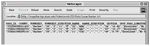
| Menu in Netscape for normal text link |
Menu in Netscape for clicking on a map |
|---|---|
 |
 |