Grid Cell Structure and Map Images
for the Hexacoral Biogeography
and LOICZ Typology Environmental Database
LOICZ Grid Cell System
The objectives of the LOICZ cell structure
are to provide a geographically structured basis for database design that
will:
-
classify coastal environments in a conceptually useful fashion;
-
permit integration and consistent analysis of available global data sets dealing with land, sea, air, and human dimension variables;
-
operate at a scale of resolution useful for the data and applications envisioned; and
-
provide a manageable number of data points for analysis and global upscaling or extrapolation.
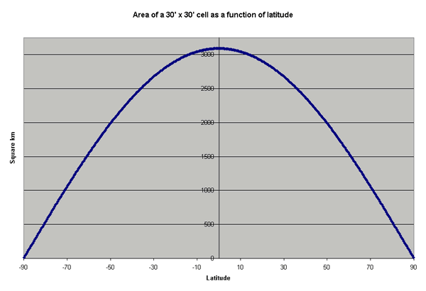
Half-degree resolution has been selected as the most realistically useful compromise between desired resolution and the available data and methods. One half degree (or thirty minutes, 30') of latitude and longitude are both equal to approximately 55 km at the equator; however, because of the earths curvature the degree of latitude is approximately constant in length, but the degree of longitude, and therefore the area of a cell, varies systematically with latitude, according to this figure:
Of
the 259200 half-degree cells on the earth's surface, a total of 47057 have
been identified as primary typology cells (coastal, terrestrial and ocean-I).
The remaining oceanic cells (145989) are included to provide complete coverage
for both the larger LOICZ budget sites and for the NOPP/OBIS partner program,
Biogeography of the Hexacorallia. This cell structure also serves the needs
of other partner projects.
Land
or Terrestrial cells (T) are typically
defined as the cells containing only land (or fresh water). Coverage typically
extends 2 cells (one degree) inland from the most landward coastal cell, although
they have been extended farther inland in a few areas (e.g., estuaries not
well represented by the shoreline data set). These will not have ocean variables.
Coastal
cells (C), defined as those containing
a significant length of the World Vector Shoreline -- these cover significant
areas of both land and (marine or estuarine) water, and will be populated
with all classes of variables.
Oceanic
I cells (OI) are those extending
seaward from the coastal cells the greater of (a) one degree, or (b) the 50
or 100 m isobath in areas of a broad shelf, or (c) to include all of a budgeted
area. These will have only oceanic and atmospheric variables.
Oceanic
II cells (OII) are those additional
cells needed to complete the infilling of relatively enclosed water bodies
or coastal seas that might be the target of future up-scaled budgeting exercises.
Oceanic III cells (OIII) cover all remaining oceanic areas not included in the other classes.
Inland Cells (I) cover all remaining land areas not covered in other classes.
Cell ID numbers are based on a sequential global grid of half-degree cells. Numbering (from 1 to 259200) begins with the cell centered at 89.5 degrees N latitude and 179.5 degrees W latitude (89.5, -179.5) and proceeds from west to east. When a full circle (or row, in a planar projection) of 720 cells (360 degrees/0.5 degrees/cell) is completed, the numbering steps one cell south along the -180 meridian and continues sequentially west to east.
Statistics on cell types and numbers
|
Cell Class |
Number of Cells |
|---|---|
|
Total primary Typology cells |
47057 |
|
Oceanic III |
143394 |
|
Oceanic II |
2595 |
|
Oceanic I |
19330 |
|
Coastal |
15278 |
|
Terrestrial |
12449 |
| Inland | 66317 |
|
Non-Typology Cells |
209517 |
|
Total number of 0.5 degree cells in the world |
259200 |
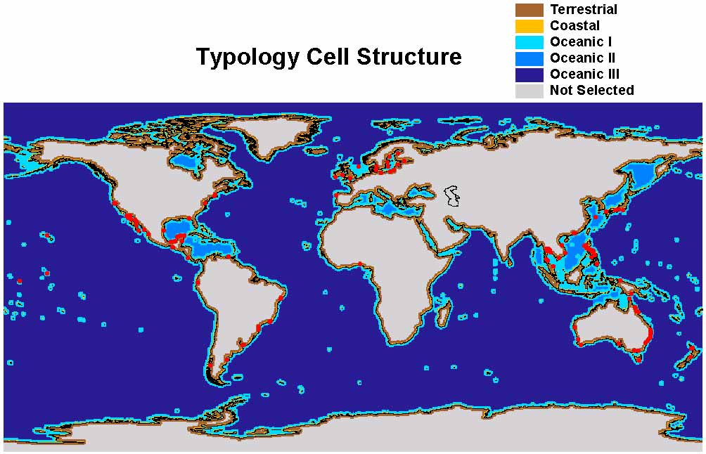
Typology cells: Illustrative views at various scales and with various features --
1. General (world) typology cell structure
2. Zoom to mid-Americas greater Caribbean general typology
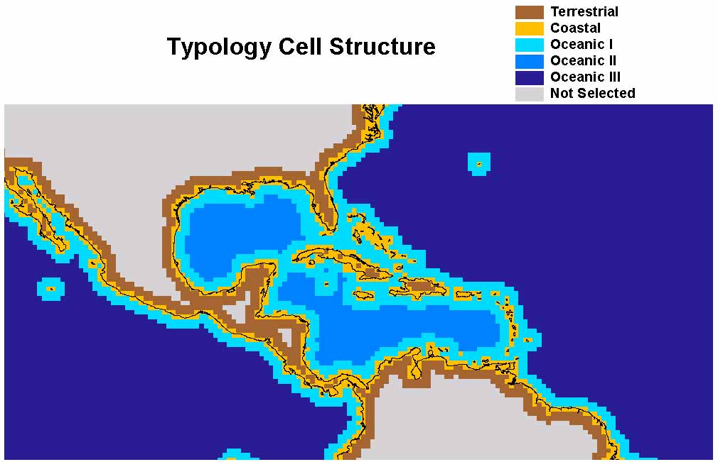
3. Further zoom to to Florida/Gulf area
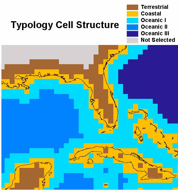
4. World typology with LOICZ budget sites (sites as of January 2001 -- inventory not current)
5. LOICZ and COML (Census of Marine Life)
6. World Basins (Building block of the basins variables)
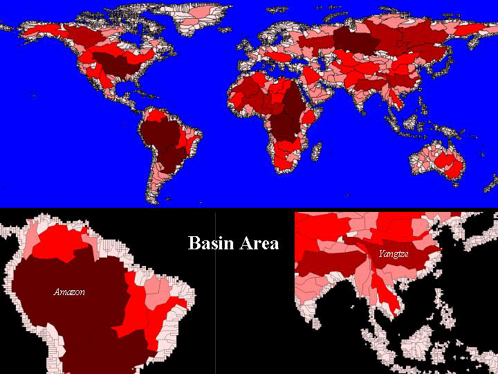
Older images of continents -- Terrestrial, coastal and ocean I cells only. Images are continuous on a single page; use links or scroll through.