River basin characteristics projected into the coastal discharge cells
Basin-scale database development is a joint undertaking of the Hexacoral, LOICZ and BAHC projects, and the University of New Hampshire
Please select from the menu below
-
1. Browse variable list and metadata tables
 --
variables
with red titles are the basin variables [metadata table currently
under construction].
--
variables
with red titles are the basin variables [metadata table currently
under construction].
-
2. Basin-scale variables -- an overview, with links to images (text and links below).
-
3. Variable types and uses -- discussion of the nature and use of continuous, discrete, and scaled-discrete variable types, and of extensive and intensive variables.
-
4. Access to the Database login page
The basin variables are fundamentally different from the other variables in the data base, in that they identify with a single cell the accumulated characteristics associated with a number of other linked cells.
The linkage is by surface water flow -- stream and river channels and the drainage basins contributing to them. Therefore, the value of basin runoff in a coastal cell is the cumulative value for all of the land area comprising the drainage for the stream that discharges through that cell. Similarly, population is the total population of the basin above the cell.
NOTE: This creates a potential problem -- to describe (and cluster) the coastal cell, we wish to have the values appropriate to that cell, independent of whether its basin is connected to other coastal cells. However, this effectively assigns the upstream basin values to all coastal cells associated with the basin, so if the data are downloaded and summed the same basin values are counted or added multiple times.
The operational solution -- we have created two classes of basin data for the coastal cells, illustrated below. The multiple outflow cell version is intended to be used for comparing and classifying the cells. The single outflow cell version should be used if the data are being combined outside of LOICZView, or if the primary focus of interest is on comparing the actual discharge values into the coastal/oceanic water bodies. These options are selected by the buttons for Single outflow cell or Multiple outflow cells in the header line for the Basin variables in the environmental database.
 |
 |
The
multiple outflow cell version assigns basin variable values to ALL coastal
cells for the basin. (Left)
The single outflow cell version ONLY includes basin variable values for
the final outflow cell for the basin.
(Right)
However, averaged or apportioned values are also available from the basin data sets -- population density, for example, is the basin average, assigned to the outflow cell. Similarly, the percent of total basin land cover of a specific type is normalized to the total area. These variables may have values of the same magnitude as the similar variables for individual cells, but the underlying total amounts are very different.
It is important not to confuse the basin variables with the similarly named local variables. For example, a coastal cell that is the outflow point of a major drrainage may have two very different 'population' numbers -- one for the local cell, and another for the entire upstream basin.
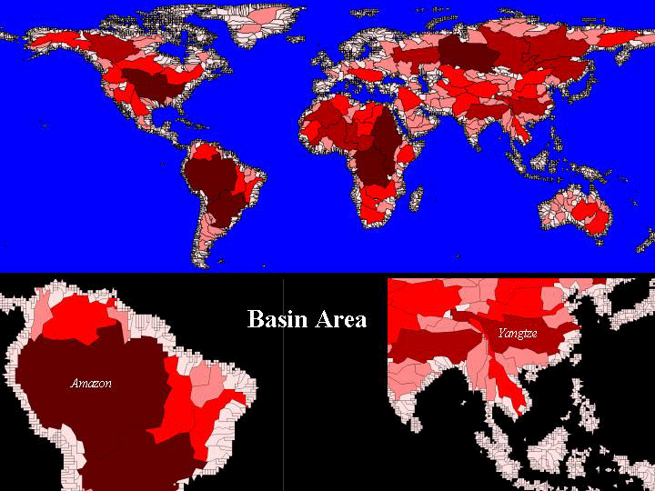
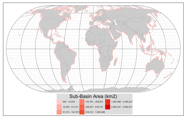
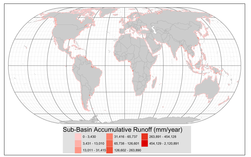
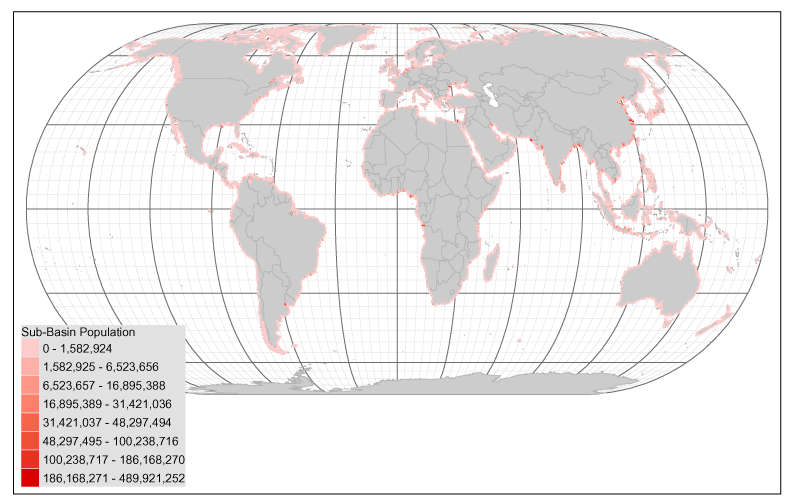
Because of the uneven distribution and great variation in basin sizes, the basin variables show a limited number of coastal 'hotspots' corresponding to major discharge points. The images linked below provide an overview of these distributions. Each map color codes the coastal cells according to the magnitude of the basin variable shown. Where flow networks are shown, the thickness of the line reflects the basin discharge.
| Basin variables projected to coastal cell classifications | |
|---|---|
| Basins of the World | World |
| Basin Area (km2) | World |
| Basin Runoff (1000 m3) | World |
| Basin Population | World |
| Basin Population Density (km-2) | World |