
|
Background and Outline of Technical Components
|
By utilizing digital well data (tops and LAS files), cores, and core analyses organized under the auspices of the Hugoton Initiative, the Sponsors and KGS are well on their way towards efficiently and accurately modeling a very large and complex reservoir system. This earlier work involved the development of
In close collaboration with the Sponsors, we propose to complete the Panoma (Council Grove) reservoir model through simulation, and to leverage the knowledge gained to model the Hugoton (Chase) in a similar manner. Functional, accurate models and simulations based on sound science and engineering and should
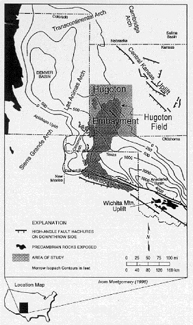
Deeper oil and gas pools of the Hugoton Embayment are also a significant and increasingly important asset to the Sponsors and the State of Kansas. For the purposes of this project, the Kansas Hugoton Embayment is defined as the 15 southwestern counties of Kansas (i.e., Finney, Grant, Gray, Greeley, Hamilton, Haskell, Kearny, Lane, Meade, Morton, Scott, Seward, Stanton, Stevens, and Wichita). While the Hugoton Embayment Permian produce 75% of Kansas gas it also yields half the annual non-Permian gas production and nearly a fourth of the oil production. The proposed catalogue of the pre-Permian oil and gas pools (Deep Pools of the Hugoton Embayment in Kansas) will provide basic production, geologic and engineering data on the deep pools of the region and serve it conveniently, online. In addition to static basic data the web-based catalogue of pools will provide dynamic maps and data visualization pages that pull data directly from the Kansas Geological Survey database in real time. The catalogue will be linked to the KGS data system providing a convenient portal to a suite of online tools available on the KGS web site. The KGS will draw on its existing tools and experience in web-based applications like those in the Digital Petroleum Atlas (see Arroyo Field example) and GEMINI, both U.S. Department of Energy funded projects. Understanding of the Hugoton and Panoma south of the Kansas border is no better than that north of the border. Southward expansion of the Permian gas systems modeling and simulation studies into the Oklahoma Panhandle will provide Sponsors with assets in those areas a cost-effective analysis of those regions as well as a better understanding of the Kansas reservoirs, particularly those in close proximity to the border. Due to data and budget constraints it is anticipated that this extension will use 20-30% of the well density for structure and geometry as did the models on the Kansas side, but a similar sample density of the more important digital well log and core data. Orginal HAMP Proposal (pdf format) |
|
| URL: http://www.kgs.ku.edu/HAMP/background.html Updated June 2004 |
|
 The
Hugoton and Panoma Fields, Permian Chase and Council Grove Groups, respectively,
are premier natural gas resources and constitute the largest gas producing
area in North America. Since 1928, the gas fields of southwestern Kansas,
including Hugoton, Panoma, Bradshaw and Byerly, have produced 27 trillion
cubic feet of gas. These reservoirs are economically important to the
State of Kansas and major gas producers, including the Sponsors in this
project. Even with a long history of substantial production, there is
no publicly available field-wide study of how best to explore, produce,
and regulate the Permian gas reservoirs. This study is designed to provide
the knowledge and technical base required for intelligent stewardship,
generation of new opportunities, and continued improvement in recovery
strategies in the Hugoton and Panoma Fields in Kansas and the Oklahoma
Panhandle. Results of earlier collaborative work by the Sponsors and
the Kansas Geological Survey (under the Hugoton Initiative project)
demonstrate that the entities work together effectively to generate
useable digital data and solve technical problems (see Council Grove
(Panoma) reservoir poster.
The
Hugoton and Panoma Fields, Permian Chase and Council Grove Groups, respectively,
are premier natural gas resources and constitute the largest gas producing
area in North America. Since 1928, the gas fields of southwestern Kansas,
including Hugoton, Panoma, Bradshaw and Byerly, have produced 27 trillion
cubic feet of gas. These reservoirs are economically important to the
State of Kansas and major gas producers, including the Sponsors in this
project. Even with a long history of substantial production, there is
no publicly available field-wide study of how best to explore, produce,
and regulate the Permian gas reservoirs. This study is designed to provide
the knowledge and technical base required for intelligent stewardship,
generation of new opportunities, and continued improvement in recovery
strategies in the Hugoton and Panoma Fields in Kansas and the Oklahoma
Panhandle. Results of earlier collaborative work by the Sponsors and
the Kansas Geological Survey (under the Hugoton Initiative project)
demonstrate that the entities work together effectively to generate
useable digital data and solve technical problems (see Council Grove
(Panoma) reservoir poster.