![]()
Prev Page--Permian || Next Page--Structure and Economic Geology
Stratigraphy, continued
Quaternary System
Extensive unconsolidated material deposited. by glacial ice, streams, wind, and slope wash overlies the Pennsylvanian and Permian bedrock throughout much of the mapped area. Terrace or alluvial deposits occur along all the major streams and their tributaries. Glacial drift, chiefly till and melt-water sediments, covers much of the uplands in the northern two-thirds of the area. Because the till and melt-water sediments (glacial outwash) are poorly exposed, these deposits were not mapped separately. Eolian loess mantles many stream divides, but because the loess is thin and poorly exposed, it was mapped either with the glacial drift or with the underlying bedrock. Mudge and Burton (1959, p. 108) recognized exposures of Peorian Loess (Wisconsin age) in the SW SE NE sec. 15, T. 11 S., R. 13 E., near Willard, and southwest of Dover in the SE sec. 10, T. 13 S., R. 13 E. This loess consists of brownish-gray to gray blocky clay and silt; locally it is iron stained and leached of calcium carbonate in its upper part. Loess deposits average about 10 foot in thickness (Mudge and Burton, 1959, p. 108). Colluvial deposits--principally of clay, silt, and very fine sand--occur over much of the area but are generally too thin to map separately; hence they were mapped with the underlying bedrock or glacial drift. In many valleys colluvium has been deposited on the back side of stream terraces at the base of valley slopes and has markedly modified the terrace forms. No contact is evident between the colluvial and terrace deposits; thus, the colluvium was mapped as a part of the terrace material.
Chert gravel--In late Tertiary or early Pleistocene time chert gravel, derived from the west (primarily from the Wreford and Barneston Limestones of Early Permian age), was deposited in the valleys of the Kansas and Wakarusa Rivers and along some of their larger tributaries; subsequent erosion has left remnants of these, deposits isolated topographically high above the present flood plains (Todd, 1918b, p. 190; Mudge, 1955, p. 273; Soott and others, 1959, p. 130). During the Pleistocene Glaciation, Kansan ice overrode many of the deposits and incorporated the chert gravel in the till and glacial outwash. Few gravel deposits remain in the area, and none are shown on the geologic map (pl. 3).
Olive-brown to pale-yellowish-brown subangular dense chert granules and pebbles in a clay matrix occur as a thin veneer locally adjacent to the streams in the SE sec. 32 and E2 sec. 34, T. 13 S., R. 13 E., near the southwest corner of the area. These gravels are probably remnants of high-level Pliocene(?) terrace deposits (O'Connor, 1955, p. 7) that formerly lay within the Marais des Cygnes River drainage basin (south of the mapped area).
A deposit of probable pre-Kansan age is exposed in an old gravel pit in the NE NW NE sec. 31, T. 10 S., R. 14 E. About 99 percent of the deposit consists of light-gray and pale-yellowish-brown subangular to subrounded chert pebbles, and about 1 percent consists of shale and sandstone pebbles in a matrix of clay and silt (Davis, 1951, table 3). A few pebbles of glacially transported materials are also present, but these pebbles were probrably added to the deposit from the overlying till by slope wash and by burrowing animals. Another deposit of probable pre-Kansan age, containing pebbles and very small cobbles of gray chert and light-gray, dusky-yellow, and grayish-red limestone, crops out along the road on the north line of the NE NE sec. 36, T. 10 S., R. 13 E. The deposit, about 1.6 foot thick, is moderately well cemented with calcium carbonate.
A third deposit of probable pre-Kansan age occurs in the SW NE sec. 13, T. 10 S., R. 13 E. This deposit appears to be composed dominantly of chert gravel overlain by till. Because of poor exposures however, it was not possible to determine with certainty that erraties are not incorporated. A deposit, possibly also of pre-Kansan age, composed of chert gravel embedded in light-yellowish-brown medium to coarse sand underlies valley fill of Kansan age in an exposure in the SW SE NE sec. 6, T. 11 S., R. 14 E.
Principal drainage in western Shawnee County and vicinity has been to the east-at least since early Pleistocene time. During Kansan Glaciation the northern two-thirds of the area was occupied by glacial ice that caused major but only temporary changes in the drainage pattern. The Kansas River was dammed at St. George, Pottawatomie County (Smyth, 1898, pl. 1; Mudge, 1955, p. 271-274), and was diverted eastward through a series of channels across northern Wabaunsee County to the present confluence of Dry Creek with Mill Creek, near Maple HilI, just west of the western Shawnee County area (Mudge, 1955, p. 274, 277-279).
The water was ponded in Dry and Mill Creeks and as the lake deepened the water rose to an altitude of about 1,115 feet and spilled southeastward across the divide between Dry and Mission Creeks (Mudge, 1955, p. 279) at the west side of the mapped area, about 3 miles northwest of Dover (fig. 14). The valley of Mission Creek also was blocked by ice below the present mouth of Haskell Creek, about 2 miles northeast of Dover. Again the water ponded, reached an altitude of about 1,150 feet, and spilled over the divide southeastward into North Branch Wakarusa River west of Auburn (Todd, 1911, p. 213), from whence it reentered the Kansas River valley east of Lawrence by way of the Wakarusa River.
Figure 14--Position of glacial diversion channels during Kansan Glaciation.
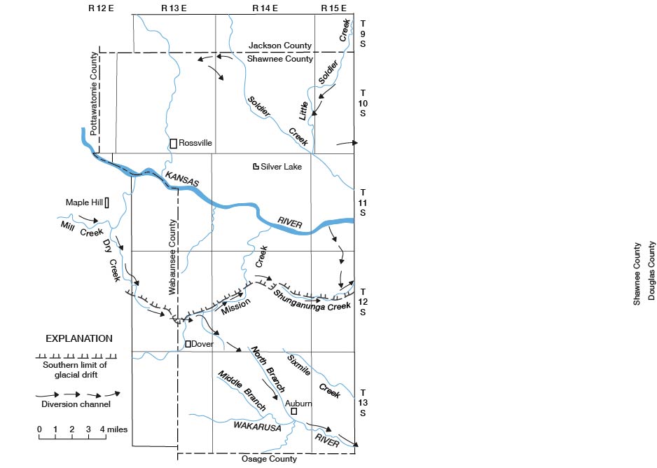
The southernmost extent of the ice sheet in the mapped area was at the approximate position of the diversion channel that extended from the west side of the area about 3 miles northwest of Dover to the mouth of Haskell Creek, northeast of Dover (fig. 14). East of Haskell Creek the southward movement of the ice was restricted by the divide between the Kansas and the Wakarusa Rivers; the ice advanced to a line that extended from Mission Creek eastward to Shunganunga Creek in the east-central part of the area. The drift border in the western part of the area north of Dover is marked by many boulders that probably are the residue of the terminal moraine. The terminal moraine in the east half of the area is partly buried in the valley of Shunganunga Creek (Smyth, 1898, p. 97-98). The presence of glacial ice over the part of the mapped area south of the Kansas River valley probably was of fairly short duration, for the diversion channels are not as deeply incised as some channels in Wabaunsee County that were utilized by the diverted river for a longer period.
As the ice gradually retreated to north of the Kansas River valley the river resumed, in general, its previous course, and its major tributaries reoccupied their old valleys. Not all the river valley within the mapped area was free of ice at the same time, for the river was diverted southward temporarily through a channel that extended from the river valley in sec. 29, T. 11 S., R. 15 E., to Shunganunga Creek in sec. 16, T. 12 S., R. 15 E., on the east side of the area (fig. 14), From there the waters probably flowed southeastward beyond the mapped area into the Wakarusa River. During the retreat, the front of the ice sheet was probably stationary just north of the Kansas River valley for a long period of time; this stability allowed a considerable thickness of glacial outwash to fill the valley.
Diversion channels are evident at several places where melt water from the glacier spilled over stream divides and interfluves as the glacier retreated northward from the mapped area. Melt water probably flowed across the divide between Cross and Soldier Creeks northeast of Rossville through a short diversion channel in the N2 sec. 1, T. 10 S., R. 13 E., and the N2 sec. 6, T. 10 S., R. 14 E., and through a channel centered near the common corner of secs. 1 and 12, T. 10 S., R. 13 E., and secs. 6 and 7, T. 10 S., R. 14 E. (fig. 14). On the east side of the area, melt water may have spilled eastward in a temporary channel in the NW sec. 33, T. 10 S., R. 15 E. Little Soldier Creek formerly flowed across the E2 sec. 18 and the NW sec. 19, T. 10 S., R. 15 E., but was diverted a short distance to the northwest into a tributary valley and did not resume its former course after retreat of the glacier. Other diversion channels undoubtedly existed but have since been destroyed or so modified by erosion as to be unrecognizable.
The glacial drift ranges in thickness from a very thin veneer at places south of the Kansas River to about 85 feet locally along the north side of the Kansas River valley, Test holes in the NW and N2 SW sec. 12, T. 11 S., R. 14 E., just north of the valley, penetrated 70-80 feet of drift (Davis and Carlson, 1952, pl. 3), and a driller reported presence of glacial drift about 45 feet thick just to the north in a water well near the SW cor. sec. 1. On the north side of the valley east of Rossville, the drift is 60-84 feet thick in test holes along the west line of sec. 32, T. 10 S., R. 14 E., and in the SW NW sec. 5, T. 11 S., R. 14 E. (Beck, 1959, p. 79-81). In general, the drift thins northward away from the river valley, but locally it is more than 20 feet thick. South of the Kansas River the outwash deposits are as much as 30 feet thick locally, but the drift apparently averages less than 5 feet in thickness.
The glacial drift is predominantly unstratified unsorted till but includes, particularly near both the terminal area and the Kansas River valley, deposits of stratified glacial outwash. Because the till and the outwash are poorly exposed, these deposits were not differentiated; over much of the glaciated area it was difficult to identify the glacial drift beneath the mantle of soil and loess. The identification and, consequently, the mapping of drift depended largely on the presence of erratics and on topographic position. The distribution of glacial drift shown on the geologic map (pl. 3) represents the minimum rather than the maximum extent. Many small areas with only a thin veneer of drift were not mapped.
Till--The till ranges from 0 to slightly more than 10 feet in thickness in quarry and roadcut exposures. Clay is the principal constituent of the till, but a large percentage of rock particles of silt, sand, granule, pebble, cobble, and boulder size are also included. Most of the till was derived from rocks that crop out in this part of Kansas, and only a small percentage consists of rock fragments from the northern part of the United States. Most fragments of pebble size or larger are limestone; smaller sized fragments are mainly sandstone and shale. In places, pale-yellowish-brown chert, incorporated in the till from the local gravel deposits of pre-Kansan age, is most abundant. Igneous and metamorphic rocks, ironstone, and quartz are also common. Cobbles and boulders of pale-red and pale-reddish-purple quartzite and quartzite conglomerate are most conspicuous, although these constituents actually compose only a small percentage of the total coarse fraction of the till (Davis, 1951, p. 191). Most boulders are less than 2 feet long, but locally some as much as 5 feet long are fairly common. The till is gray and weathers light brown or pale reddish brown. Where it is deeply weathered, much of the clay, silt, and sand fraction has been removed, and a concentrate of pebbles, cobbles, and boulders now remains. The concentrate contains a higher percentage of glacial erratics than fresh till. The largest concentration of boulders occurs in the area formerly occupied by the terminal moraine of the ice sheet. Boulders are particularly abundant northwest of Dover in sec. 22, the W2 sec. 23, and near the common corner of secs. 8, 9, 16, and 17, T. 12 S., R. 13 E.
Glacial outwash--The glacial outwash consists of stratified clay, silt, sand, gravel, and many random cobbles and boulders, deposited by melt water from the Kansan ice sheet during its advance and retreat. The outwash deposited during the ice advance is classified as the Atchison Formation (Moore and others, 1951, p. 15) by the State Geological Survey of Kansas; the deposits of the retreatal phase are classified as the Grand Island and Sappa Formations. The composition of the outwash is complex and varied, and seldom can the Atchison and Grand Island Formations in this part of Kansas be definitely separated on the basis of lithology. In fact, the Atchison is recognized with reasonable certainty only where it is overlain by Kansan Till. The Sappa Formation overlies the Grand Island and is made up chiefly of silt of glaciofluvial and glaciolacustrine origin. In the mapping of the area, the glacial outwash was not differentiated into the three formations. Deposits of the Grand Island and Sappa Formations were included in the Menoken Terrace deposits by Beck (1959), and in the Meade Formation by Davis and Carlson (1952).
The proglacial outwash--the Atchison Formation--commonly consists of indistinctly crossbedded gravel interstratified with medium to coarse sand. Some gravel lenses are moderately well cemented by calcium carbonate. In some places the pebble-sized rock fragments are chiefly chert and limestone but some are shale and sandstone and a few are glacial erratics (Davis and Carlson, 1952, p. 222). At other localities the Atchison contains a large percentage of glacial erratics and is indistinguishable from the Grand Island Formation.
Pebbles 4-8 millimeters long, examined by Davis (1951, table 3), from the Atchison in a gravel pit in the center of the SW sec. 9, T. 11 S., R. 15 E., were about 55 percent limestone, 36 percent chert, 9 percent shale and sandstone, and less than 1 percent quartzite and granitic erratics. In a small pit in the center of the N2 SW sec. 7, T. 11 S., R. 15 E., chert is the dominant rock among the gravel-sized fragments, particularly those fragments more than 8 millimeters long (Davis, 1951, table 3). The Atchison Formation in a large pit in the SW cor. sec. 26, T. 10 S., R. 13 E., is composed of 4 feet of stratified coarse sand containing sorted gravels overlain by 8 feet of sorted gravels and cobbles mainly of limestone. Overlying this unit is about 17 feet of light-gray silt that shows well-formed deltaic bedding with apparent dip to the southeast; about 5 feet of clay till and soil cap the deposit. About 10 feet of well-sorted subrounded gravel of the Atchison is exposed below till in a gravel pit in SE SE sec. 9, T. 10 S., R. 14 E., northeast of Grove. The possible varved sediments in the SE SE sec. 28 and the SE sec. 29, T. 11 S., R. 13 E., described by Mudge and Burton (1959, p. 102), may belong to the Atchison. They consist of very fine sand, silt, and clay in alternating bands of light and dark gray brown and contain granule-sized erratics.
A deposit, possibly in the Atchison Formation, composed of poorly stratified sand, granules, pebbles, cobbles, and boulders, as well as large masses of till, fills part of a preglacial valley in the E2 sec. 10 and the west-central part of sec. 11, T. 12 S., R. 13 E. This deposit was classified by Mudge and Burton (1959, p. 103) as an ice-contact deposit. The matrix material of the deposit ranges in size from coarse sand to granules and is composed dominantly of subangular to subrounded limestone fragments; but it also includes a large amount quartz and smaller amounts of chert, ironstone, and igneous and metamorphic rock. The material contains abundant pebbles, most of which are less than 0.17 feet long, mainly of limestone but partly of pale-yellowish-brown chert. Cobble-sized fragments are common and some boulders are present. The larger fragments of granitic rock are deeply weathered and crumble when struck. The deposit shows deltaic bedding with apparent dip to the southeast, and much of the deposit is moderately well cemented by calcium carbonate and is deeply stained by limonite. The deposit is more than 30 feet thick and rests on bedrock. Mudge and Burton (1959, pl. 2) also recognized small ice-contact deposits in the center and NE cor. sec. 9 and in the adjacent part of sec. 10, T. 12 S., R. 13 E.
Gravel of the Grand Island Formation, described by Lugn (1935, p,103-104) as "the inwash-outwash equivalent of the Kansan till and the early Kansan inter-till sands and gravels of eastern Nebraska," composes most of the glacial outwash in the area; this gravel is thickest and most extensive along the north side of the Kansas River valley. The Grand Island is well exposed in a large pit in the center of the SW sec. 9, T. 11 S., R. 15 E., where it is about 18 feet thick and contains 14 feet of coarse gravel overlain by 4 feet of coarse sand. The gravel is interbedded with lenses of yellowish-gray very fine to fine sand containing limestone and quartzite boulders as much as 2 feet in diameter. Some of the gravel is cemented by calcium carbonate. The deposit shows deltaic bedding. The sand is pale reddish brown and medium to coarse and contains scattered pebbles. Davis (1951, table 3) found that of the gravel 4-8 millimeters in length, about 49 percent was limestone, 23 percent was chert, 10 percent was shale and sandstone, and the remaining 18 percent was glacial erratics-mainly quartz and metamorphic and granitic rocks.
The Grand Island, which consists of 9 feet of very coarse sand and very small pebbles overlain by 2 feet of dark-reddish-brown silt, is well exposed in a gravel pit on the south side of the Kansas River in the S2 SE sec. 24, T. 11 S., R. 13 E. The pebbles in the lower part are primarily dark-yellowish-gray to dark-yellowish-brown and moderate-reddish-brown limestone, but quartz, chert, and sandstone are also common. The basal 4 feet has indefinite bedding, some moderately well cemented gravel lenses, and very thin streaks of gravel coated with brownish-black manganese oxide; it weathers light yellowish gray. The upper 5 feet of the very coarse sand contains some subangular to subrounded boulders as much as 1.2 feet long and irregular lenses of olive-gray pebbly clayey silt; it weathers dark brown and is also streaked with manganese oxide. The silt at the top of the deposit contains pebbles of limestone and glacial erratics. Some large cobbles of light-red quartzite are also present. The poorly defined bedding of the deposit dips eastward.
About 17 feet of partly to moderately well cemented gravel, probably of the Grand Island, is exposed in an abandoned pit in the SW NE sec. 18, T. 10 S., R. 15 E., on the south side of Little Soldier Creek. The deposit overlies the Wakarusa Limestone Member of the Bern Limestone, and its bedding seems to dip to the southwest. The gravel exposed in the basal 6 feet of an old pit in the NW SE sec. 12, T. 11 S., R. 14 E., is also correlated with the Grand Island. At many localities the poorly sorted and stratified glacial outwash of the Grand Island closely resembles gravel and boulder till, or till from which much of the original clay and silt has been removed.
A lag concentrate of pebbles, cobbles, and boulders of limestone and glacial erratics is the remnant of glacial outwash along the diversion channel in the valley of the North Branch Wakarusa River. In a few places along that stream small deposits of sand and gravel are also present. In the stream gully in the SW NW sec. 3, T. 13 S., R. 14 E., blocks of limestone, pink quartzite, and greenstone are imbedded in sand. Most of the erratics are scattered along the east side of the valley at levels ranging from 5 feet above the stream near its headwaters to as much as 60 feet above the stream near its mouth. Near the southeast corner of the mapped area, a deposit of glacial outwash containing pebbles and cobbles of limestone and pink quartzite caps a small hill on the north side of the Wakarusa River in the NE SE sec. 29, T. 13 S., R. 15 E. This deposit is about 80 feet above the river.
Thick deposits of pale-yellowish-brown to pale-red clayey to finely sandy silt and fine sand, assigned to the Sappa Formation (Condra and others, 1947, p. 12, 22), are present on the north side of the Kansas River valley but are concealed by loess and soil. About 14 feet of sediments, probably in the Sappa, consisting of well-sorted medium to coarse arkosic sand that grades upward into fine darkstained sand, silt, and clay overlies gravel of the Grand Island Formation ina pit in the NW SE sec. 12, T. 11 S., R. 14 E, (Beck, 1959, p. 31). Good exposures of the Sappa are present in the north bank of Soldier Creek about 2.5 miles east of the report area, in the SW sec. 12, T. 11 S., R. 15 E., where the formation is more than 40 feet thick.
Terrace Deposits of Kansan Glaciation
South of the glaciated area along Mission Creek, deposits of gravel, probably contemporaneous with the glacial outwash, occur as terraces mainly along the north side of the creek (Mudge and Burton, 1959, p. 105). About 9 feet of Kansan terrace gravel is exposed in a pit in the NW NW sec. 3, T. 13 S., R. 13 E. The lower half of the deposit consists mainly of subangular to subrounded granules and pebbles dominantly of limestone but also of chert, quartz, and ironstone. The upper half is mainly very fine to very coarse sand composed of fragments of limestone, sandstone, chert, quartz, ironstone, and fossils. Some moderately well cemented lenses of sand and gravel occur in the sand. Bedding in the sand dips to the east-southeast. The toe of the terrace of Kansan age is about 10 feet above a lower terrace in Mission Creek valley and about 40 feet above the present stream channel. The back side of the terrace deposit is concealed by loess and colluvium of younger age that mantle the north slope of this part of Mission Creek valley; because the contact between the two deposits is difficult to determine, they were not mapped separately. Mudge and Burton (1959, p. 104, pl. 2) included the Kansan terrace deposits in the Grand Island Formation and the colluvium in the Sanborn Formation (now considered the Sanborn Group).
Terrace deposits correlated with the Buck Creek terrace of Illinoian age, as defined by Davis and Carlson (1952, p. 213) farther downstream in the Kansas River valley, occur on the south side of the Kansas River west of Willard, on the north side west of Rossville, and along its major trihutaries. Terrace remnants questionably correlated with the Buck Creek terrace deposit are also present along the Wakarusa River. A test hole in a narrow unmapped Buck Creek deposit along the north side of the Kansas River valley in the NE NE sec. 19, T. 11 S., R. 13 E., penetrated 49 feet of sediments consisting, in ascending order, of 15 feet of yellow silty friable clay; 14 feet of clayey sand and gravel composed of quartz, limestone, quartzite, and some igneous rock; 2 feet of clay containing quartz, quartzite, and limestone pebbles; 12 feet of light-brown silty calcareous clay; 2 feet of slightly sandy calcareous si1t containing a few subangular pebbles; and 4 feet of black silt and clay (Beck, 1959, p. 78). The upper 15 feet of clay in the test hole is probrubly colluvium of more recent age. Generally only the upper few feet of the Buck Creek deposits is exposed; it is reddish-brown and pale-yellowish-brown to light-brown clayey coarse silt containing scattered granules and pebbles.
In the Kansas River valley the Buck Creek deposits are about 30-80 feet above the river. The extensive remnant of the Buck Creek terrace along the west side of Cross Creek north of Rossville ranges in height from about 20 foot to as much as 90 feet above the creek locally in the NW NW sec. 10, T. 10 S., R. 13 E. The higher part of the deposit overlies bedrock. Remnants of the Buck Creek terrace along Mission Creek range in height from as much as 45 feet above the creek near its mouth to as little as 15 feet above the creek at the west edge of the area, near Dover. The few exposures of the Buck Creek ( n terrace deposits along the Wakarusa River show light-reddish-brown silt, locally containing gravel of yellowish-brown chert and light-pink quartzite. Because they are partly covered by colluvium and loess, the Buck Creek terrace deposits in the area can be delineated only generally.
Alluvial deposits of Wisconsin age occupy much of the bottom land of the Kansas River valley and almost entirely cover the bottom of the valleys of the Wakarusa River and major creeks (pl. 3). In the Kansas River valley the deposits underlie a nearly flat poorly drained terrace surface--the Newman--which is 20-45 feet above the river. The Newman is best preserved on the north side of the river, where it ranges in width from about 700 feet to almost 2 miles and averages slightly more than 1 mile in width. Together, the Newman and the alluvium form the flood plain of the Kansas River; however, only severe floods inundate the terrace, and the high points remain above flood level.
Test holes drilled in the Newman east and west of Silver Lake and near the west edge of the mapped area showed that the deposit is 50-75 feet thick (Beck, 1959, p. 78, 81, 82; Davis and Carlson, 1952, pl. 3). According to Beck, the lower two-thirds to three-fourths of the deposit is sand that, near its base, contains a considerable amount of gravel. The sand is coarse in its lower part and grades upward into medium to very fine sand. A few lenses of clay also occur in the gravelly sand. The upper part of the Newman terrace deposit is mainly sandy clay capped by a layer of clayey silt. Colluvial material derived by slope wash from the valley sides mantles the Newman deposits at most places adjacent to the valley slopes.
Newman terrace deposits form most of the flood plain of the Wakarusa River and most of those of major creeks in the area; in ordinary floods these deposits are covered. The Wakarusa River and the creeks have cut channels 10-15 feet below the level of the flood plains on the Newman deposits. The thickness and composition of the Newman deposits outside the Kansas River valley are not known, but a test hole drilled near Soldier Creek in the NE NE NW sec. 8, T. 11 S., R. 15 E., near the mouth of the valley reportedly penetrated 35 feet of mud (probably clay and silt) underlain by 12 feet of gravel.
The alluvium along the Kansas River ranges in width from about 1 mile near the east edge of the area to 3.5 miles near the west edge. Together with the Newman terrace it forms the flood plain of the river. A scarp commonly marks the contact between the alluvium and the Newman terrace. Along creeks this scarp is generally less than 5 feet high, and in many places it is obscure Locally between Rossville and Silver Lake, alluvium occupies most of the valley bottom. The alluvial surface is irregular and is marked by meander scars that in places contain small lakes; of these, Silver Lake is the largest. The upper 6-10 feet of alluvium is silt and silty clay that grades downward into very fine to coarse sand containing gravel, some boulders, and some clay lenses in its lower part (Beck, 1959, p. 82, 83).
Along some of the larger tributaries of the Kansas River, alluvium borders the streams in the upper reaches of the valleys, but downstream, where the channels are more deeply incised, it is too narrow to be shown on the geologic map. Along the narrow channel of the Wakarusa River, the alluvium was included with the Newman deposits. Near the mouths of the creeks, the channel bottoms are broader, and, therefore, the alluvium is wider.
Prev Page--Permian || Next Page--Structure and Economic Geology
Kansas Geological Survey, Geology
Placed on web October 2005; originally published 1967.
Comments to webadmin@kgs.ku.edu
The URL for this page is http://www.kgs.ku.edu/General/Geology/Shawnee/W/06_quat.html