![]()
Prev Page--Abstract || Next Page--Geography
Introduction
Purpose and Scope of the Investigation
In July, 1939, an investigation of the geology and ground-water resources of Morton County, Kansas, was undertaken by the United States Geological Survey and the State Geological Survey of Kansas, with the cooperation of the Division of Sanitation, Kansas State Board of Health, and the Division of Water Resources, Kansas State Board of Agriculture. This work was done under the general administration of R. C. Moore and K. K. Landes, state geologists, and O. E. Meinzer, geologist in charge of the Division of Ground Water of the Federal Survey, and under the direct supervision of S. W. Lohman Federal geologist in charge of ground-water investigations in Kansas.
Since 1931 an extended drought, accompanied by severe dust storms, has caused repeated crop failures in western Kansas. These conditions have resulted in a lower farm income and an increased interest in the possibilities of irrigation in this area.
During the last nine years Morton County has had an average annual precipitation far below normal, resulting in a cumulative deficiency in rainfall for the nine years of more than 61 inches.
The investigation upon which this report is based was made in order to determine as nearly as possible the quantity, quality, movement and availability of the ground water, and the location and extent of areas in which ground water may be developed for irrigation. The present use of water for domestic, stock, public, and irrigation supplies does not seem to be depleting the supply of ground water in this county, but it is possible that future overdeveloping of water for irrigation in shallow-water areas might seriously endanger this supply. It is hoped that the data given herein will facilitate the safe development of the ground-water resources of the county.
Location and Size of the Area
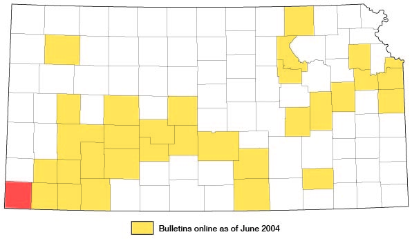
Morton County is in the southwestern corner of Kansas (fig. 1). It is bordered on the south by Oklahoma and on the west by Colorado. Most of the county lies between parallels 37° and 37° 24' north latitude and meridians 101° 33' and 102° 3' west longitude. It includes 20 townships and has an area of 733 square miles.
Figure 1--Index map of Kansas showing area described in this report and areas covered by other geologic maps, as of July 2004. For additional information, the KGS Geologic Maps of Kansas Page.
Previous Work
The first studies of the ground-water resources of western Kansas were made in 1895 by Haworth (1897, pp. 49-114), who discussed the occurrence of ground water in the Cockrum sandstone and younger formations of western Kansas. A few years later Johnson (1900, pp. 601-741, 1901, pp. 631-669) made a study of the southern High Plains with special reference to ground water, its source, its availability, and its use. At about the same time Darton (1905) studied the geology and ground-water resources of eastern Colorado and western Kansas, including Morton County. In 1911 Parker(1911) reported on the chemical characters of the water supplies of Kansas and described briefly the geology and ground-water conditions of each county.
Theis, Burleigh, and Waite (1935) made a two-year reconnaissance of the ground-water resources of the southern High Plains and released a mimeographed summary of their findings. Later, Schoff (1939) made a detailed study of the ground water in Texas county, Oklahoma, including a section on the uplands in adjacent parts of Oklahoma and Kansas. Texas county borders Morton County on the south and has many similar hydrologic problems. Smith (1941) made a reconnaissance of the Tertiary and Quaternary geology of southwestern Kansas.
Methods of Study
The field work in Morton County was done during July, August, and part of September, 1939. Measurements were made with a steel tape in about 120 wells to determine the depth of the well and the depth to the water level below some arbitrary measuring point (generally the top of the casing). Periodic water-level measurements were made in 19 representative wells in the county in order to obtain information on the fluctuations of the ground-water table. Thirty-six samples of water from representative wells were collected, and were analyzed by Robert H. Hess, chemist, Kansas State Board of Health.
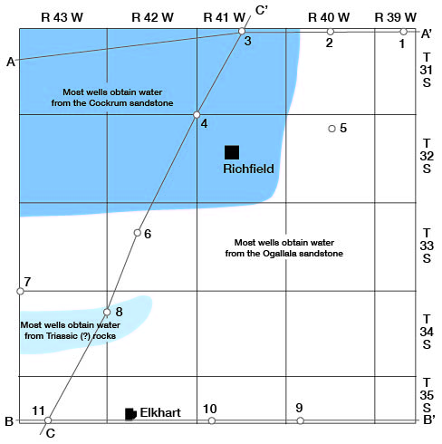
Eleven test holes were drilled at strategic points in the county by the portable hydraulic-rotary drilling machine of the State and Federal Surveys, operated by Ellis D. Gordon and Perry McNally. The locations of the test holes are shown in figure 2. The depths of the test holes ranged from 90 to 430 feet (see well logs). Five of the test holes were drilled to the Cockrum sandstone and seven penetrated Triassic (?) or Permian redbeds. The drill cuttings were collected and studied in the field by Perry McNally and were later examined with a microscope in the office. Considerable information was obtained from landowners, tenants, and drillers concerning the nature and thickness of the water-bearing beds, the quantity and quality of water available, and the use to which it is put. Well logs were obtained from water-well drillers and from companies that have drilled gas wells in the Morton County section of the Hugoton gas field. The altitudes of the measuring points of some of the water wells and of a few test holes were determined with a plane table and alidade by a level party of the Topographic Branch of the Federal Geological Survey, headed by J. B. LaDuex. This level work was done as a part of the regular cooperative topographic mapping program of the Federal and State Geological Surveys. The altitudes at the rest of the test holes were determined by the well-drilling crew--Gordon and McNally.
Figure 2--Map of Morton County showing location of test holes, lines along which cross sections are drawn (plate 6 A-C), and areas in which the principal water-bearing formations supply water to wells.
The field data were recorded on land-ownership maps, and were transferred in the office to a highway map of the county prepared for the Kansas Highway Planning Board by the Kansas Highway Department (pls. 1 and 2). The roads and drainage were corrected from field observations and from aerial photographs taken by the United States Department of Agriculture. A geologic map (pl. 1) was made mainly from field observations of the rock outcrops but in part from the soil map of Morton County prepared by Joel (1937). A study was made of the various kinds of soil and the rock types from which they were developed. The soil is so closely related to the parent rock from which it is derived that much of the geology, particularly the areal extent of the loess, is revealed by the soil maps. The map showing the depths to water level (pl. 2) is based mainly upon measured water levels in many wells in the county (table 6).
The wells shown on plate 2 were located within the sections by use of the speedometer, and the locations are accurate to about 0.1 mile. The wells are numbered by townships from north to south and by ranges from east to west, and within a township the wells are numbered in the same order as the sections. For each well shown on plate 2 the number above the line corresponds to the number of the well in the well tables and the number below the line is the depth to the ground-water table below a fixed measuring point.
Acknowledgments
Residents of the area were very cooperative in giving permission to measure their wells and in giving information on water supplies. Thomas Harford, of the Kansas City Power and Light Company, supplied well lags and other data on the municipal wells at Elkhart; Perry Williams gave similar information on the municipal well at Rolla; and Jake Kilbourne provided data on wells drilled by him in Morton County. The county engineer, E. C. Dean, supplied maps, well logs, and other data.
The manuscript for this report has been reviewed critically by S. W. Lohman, O. E. Meinzer, and W. D. Collins, of the Federal Geological Survey; R. C. Moore, state geologist; Ralph H. King, State Geological Survey editor; Earnest Boyce, director of the Division of Sanitation of the Kansas State Board of Health; and George S. Knapp, chief engineer of the Division of Water Resources of the Kansas State Board of Agriculture. The maps and cross sections were prepared by G. W. Reimer, draftsman of the State Survey.
Prev Page--Abstract || Next Page--Geography
Kansas Geological Survey, Morton County Geohydrology
Comments to webadmin@kgs.ku.edu
Web version Sept. 2004. Original publication date March 1942.
URL=http://www.kgs.ku.edu/General/Geology/Morton/03_intro.html