


Kansas Geological Survey, Open-File Rept. 91-1a
Pre-Graneros Paleogeography--Page 6 of 16
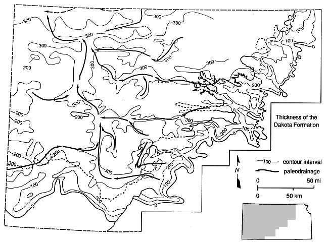
Large-scale cyclical variations in relative sea level, of the order of 3-5 m.y., formed the unconformity-bounded Cheyenne-Kiowa, J, and D depositional sequences (Hamilton, 1989). The unconformities were formed during relative sea-level falls and lowlands. During lowstands, deposition was restricted to the basin center, and the eastern and western margins were subaerially exposed. As a result, Cretaceous strata deposited nearer the axis of the seaway have more marine components than strata nearer the edge, such as in central Kansas. Before deposition of the Cheyenne and the Longford Member of the Kiowa Formation, the major stream systems flowed westward to the sea that was encroaching on the western interior from the north (Hamilton, 1989). Valleys formed by erosion during sea-level falls, before Cheyenne Sandstone-Kiowa Formation deposition (97 m.y., and 95 m.y. ago, respectively) were filled with sediment during a subsequent relative rise in sea level. Before deposition of the J and D sequences, streams generally flowed westward across Kansas to a major northwestward-flowing trunk stream in western Kansas. The major elements of this paleodrainage system are clearly outlined by thickness trends of the Dakota Formation in western and central Kansas (Macfarlane et al., 1990) (Figure 9).
Core data from the central Kansas test holes show that positive topographic elements on the Permian surface controlled the orientation of the Kiowa sea coastline and the deposition of sediment in paralic facies tracts. This is suggested by the presence of a black marine shale directly above the Permian surface followed by a thick succession of Longford strata deposited in a tidal-deltaic environment in the KGS #1 Jones test hole. During the initial transgression by the Kiowa sea, the coarser sediments would have filled in the existing stream valleys first. In particular, fluvial Cheyenne Sandstone deposits in the Braun #1, #1 Brungardt, and Haberer test holes are evidence that a westward-flowing paleodrainage existed across the Central Kansas uplift before transgression. The occurrence of black shale above the Permian-Cretaceous unconformity in the KGS #1 Jones test hole and farther east in the outcrop areas of Clay County (Walters and Bayne, 1959) and farther south in Ellsworth, Saline, and McPherson counties (Franks 1966, 1979 and Bayne et al., 1971) suggests that these areas were topographically higher than the incised river valleys to the north and west. This is consistent with an extension of the inferred earliest Cretaceous paleodrainage divide of Hamilton (1989) into central Kansas. Thus the Kiowa sea shoreline must have rapidly traversed the central Kansas area from the west in an easterly direction. This differs significantly from Frank's (1966, 1979) interpretation of data gathered in the outcrop areas of central Kansas. He believed that the Kiowa sea shoreline moved in a northeasterly direction across Kansas.
Figure 9. Regional thickness variations of the Dakota Formation and inferred paleodrainage pattern in Kansas.
Higher in the Kiowa, vertical succession of Longford progradational deposits in all the test-hole locations and in outcrop suggests that a slightly emergent coastline extended into the Kiowa sea following transgression into the central Kansas area. The emergent nature of the coastline is apparent from the alternation of subaqueous deltaic and overbank deposits in the upper part and the preservation of plant roots in beach sediments in the lower part of the Kiowa section of the KGS #1 Jones core and indicates that sea-level rise may have slowed or stagnated in this area. Later Kiowa events are unknown in central Kansas because of truncation of the overlying strata by the J unconformity.
A drop in sea level terminated deposition of the Kiowa Formation in central Kansas, and the coastline retreated once again, resulting in exposure and erosion of Kiowa Formation strata. During this period, a paleotopographic surface (the J unconformity) with locally greater than 100 ft (30 m) of relief was produced by erosion in central Kansas (Figure 8). Paleocurrent directions determined from the lowest Dakota Formation channel sandstones outcropping in Washington County (Franks, 1966; Karl, 1976) indicate that these rivers drained in a west-southwesterly direction.
Most of the sediment of the Dakota Formation was deposited above sea level by these rivers. Fluvial deposition began first in the lower parts of the terrane in response to rising sea levels associated with eastward transgression of the Western Interior seaway toward Kansas (Hamilton, 1989). During subsequent fluvial deposition, mainly from overbank flood events, the relief was gradually diminished to a nearly flat alluvial plain. The maximum eastward extent of the transgression associated with the J sequence is unknown in Kansas because of trancation of the turnaround point by the D unconformity. Falling sea levels terminated deposition of the J sequence in the lower part of the Dakota Formation in central Kansas, and subsequent erosion resulting from subaerial exposure created the D unconformity.
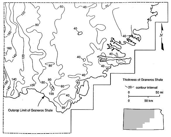
From examination of outcrops in central Kansas, Hamilton (1989) interpreted a change in fluvial systems across the D unconformity from meandering to brainded streams. The nature of the later Dakota fluvial architecture and aggradation of the rivers are consistent with the eastward advance of the shoreline as the Graneros sea transgressed across Kansas. In response to rising sea levels, the upward succession of depositional environments between the basal D unconformity and the base of the Graneros Shale is from fluvial to deltaic (Figure 8). The presence of gray mudstones containing siderite nodules and thin lignites in the upper Dakota above the D unconformity indicates an environment of deposition close to the water table. We interpret deposition to have taken place in a flood-plain environment that graded westward into a more marshy flood basin, presumably near the Graneros sea coastline. The coastline itself was irregular, with lobes of a river-dominated delta system prograding into the transgressing Graneros sea. This delta system incorporated many features of modern river-dominated deltas, such as the Mississippi delta, including interdistributary bays, swamps, and abandoned distributary channels. Thus the Graneros sea was a generally low-energy marine environment with limited tidal range or wave power. Frank's (1966, 1979) conclusions vary only slightly from this viewpoint; he suggested that transgression occurred from southwest to northeast across Kansas. A statewide isopach map of the Graneros Shale (Figure 10) shows a distinct west to east thinning of the Graneros Shale, which we interpret as a north-south paleoshoreline trend.
Figure 10. Regional thickness variations of the Graneros shale showing a pronounced west to east thinning and a north-south orientation of the isopach lines.
Previous page--Surface and Subsurface Sections
Start of this report ||
Table of Contents