


Kansas Geological Survey, Open-File Rept. 91-1a
Pre-Graneros Paleogeography--Page 2 of 16
Core Retrieval, Collection of Drill Cuttings, and Geophysical
Logging Operations
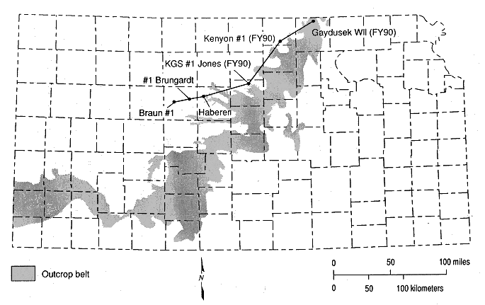
Three test-hole sites were drilled during FY90 in Lincoln, Republic,
and Washington counties, north-central Kansas, just west of the outcrop
belt of the strata that comprise the Dakota aquifer (Figure 1). All the
test holes were cored and logged. One test hole, the Haberer, was cored
and logged during FY89. Each of these test holes was cored using a
wire-line coring device that allowed for the continuous collection of
2-in. (0.8 cm.) diameter core samples of the strata penetrated while
drilling. Core recovery was highest in the more consolidated
mudstone-rich and cemented sandstone portions of the pre-Graneros
section and poorest in the thicker sections of friable sandstone. On
completion of the coring, each test hole was logged by Schlumberger, a
commercial geophysical-logging company, using a diverse combination of
tools to provide lithodensity, porosity, and fluid properties
information. Two other test holes, the #1 Brungardt (drilled in FY89)
and the Braun #1 (drilled in FY87), were drilled and logged but not
cored. Interpretation of the strata penetrated by the test hole was
from cuttings collected while the holes were being drilled. Logging
runs were made to produce spectral and conventional gamma-ray
spontaneous potential, shallow and deep spherically focused induction,
photoelectric absorption, neutron-density, and gamma-gamma density logs
of each borehole.
Figure 1. Geographic location of the FY90 and other test holes
in the Dakota Aquifer of Kansas.
Previous page--Start and Abstract ||
Next page--Regional Sequence Stratigraphy
Start of this report ||
Table of Contents
Kansas Geological Survey, Dakota Aquifer Program
Original report available from the Kansas Geological Survey.
Electronic version placed online Oct. 1998
Comments to webadmin@kgs.ku.edu
URL=http://www.kgs.ku.edu/Dakota/vol3/ofr91_1a/rep02.htm