


Kansas Geological Survey, Open-File Rept. 91-1a
Pre-Graneros Paleogeography--Appendix 4
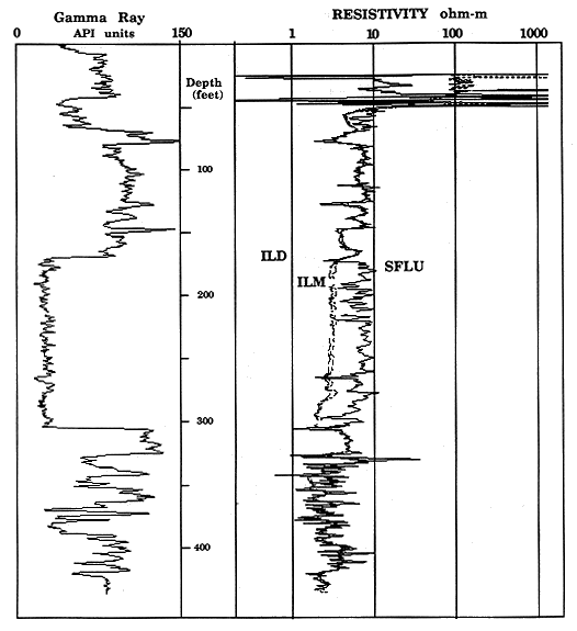
The Haberer was drilled in NE, SE, NE Sec. 14, T. 12 S., R. 15 W., Russell County, Kansas, in August 1988. The test hole began in the upper part of the Graneros Shale [approximately 5 ft (1.5 m) below the top] and ended in the lower part of the Cheyenne Sandstone at a total depth of 443 ft (135 m). Figure 5.1 through 5.4 show the geophysical logging traces from the borehole. A detailed description of the core retrieved and its interpretation are given in what follows.
Figure 5.1. Gamma-ray and caliper logs of KGS Haberer #1 NE-SE-NE 14-12S-15W indexed with stratigraphic subdivisions.
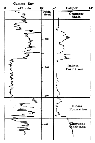
Figure 5.2. Gamma-ray and lithodensity-neutron logs of KGS Haberer #1 NE-SE-NE 14-12S-15W indexed with stratigraphic subdivisions.
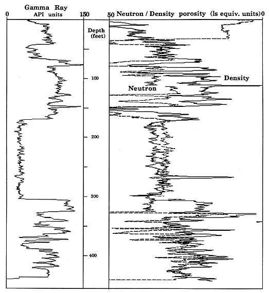
Figure 5.3. Spectral gamma-ray logs of KGS Haberer #1 NE-SE-NE 14-12S-15W, Russell Co., KS.
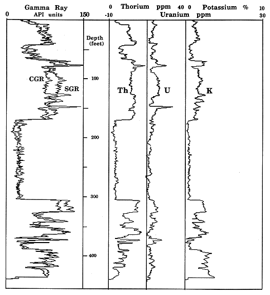
Figure 5.4. Gamma-ray and resistivity logs of KGS Haberer #1 NE-SE-NE 14-12S-15W indexed with stratigraphic subdivisions.
0-43 ft (0-13 m)
Core was not taken from 0-34 ft (0-10 m). From 34-43 ft (10-13 m) the core is gray shale with interbeds of horizontally laminated sandstone and shale that is bioturbated by Planolites. This part of the core is within the upper part of the Janssen Clay Member of the upper Dakota Formation. The contact with the Graneros Shale is probably at 26 ft (7.9 m). The depositional environment was offshore shallow marine but is separated from the Graneros Shale by a transgressive surface of erosion.
43-68 ft (13-21 m)
This section coarsens upward from a gray mudstone to an upper fine-grained sandstone. The sandstone is horizontally laminated and bioturbated by Planolites. The environment of deposition was middle to upper shoreface. This represents the first incursion of marine conditions in the Dakota Formation in this locality.
68-80 ft (21-24 m)
Carbonaceous shale grades upward into variegated mudstone, which is capped by a mottled sandstone. This strata represents swamp and flood-plain environments that existed at the end of deposition of the Terra Cotta Clay Member.
80-117 ft (24-35.7 m)
This part of the core consists of a thick section of variegated mudstones that are capped by a thin siltstone and sandstone. All the strata contain evidence of compaction and dewatering structures and are representative of overbank deposits. Sideritic spherulites are abundant in the variegated mudstones.
117-150 ft (35.7-45.7 m)
Interbedded siltstone, sandstone and variegated mudstone characterize this section of core. Compaction and dewatering structures and pyrite and sideritic spherulites are prevalent. Both dry and wet conditions existed in this overbank environment, as evidenced by a soil zone at 144 ft (43.9 m) and a carbonaceous shale at 130 ft (39.6 m).
150-168 ft (45.7-51.2 m)
This section is entirely massive variegated mudstones and was deposited in a flood-plain setting.
168-310 ft (51.2-94.5 m)
Only the upper 6 ft (1.8 m) of this poorly consolidated sandstone was recovered. The sandstone is medium grained, has high-angle cross-laminations, and is capped by a soil zone.
310-330 ft (94.5-101 m)
Gray mudstone makes up this part of the core. Leaves and pieces of wood are abundant in places and indicate a bay environment of deposition.
330-366 ft (101-112 m)
This part of the core consists of two coarsening-upward cycles [divided at 346 ft (105 m)]. Each starts with gray shale at the base and grades up into ripple and cross-laminated, fine-grained sandstone. Bioturbation in the sandstone is by both Planolites and Skolithos. Deposition of each cycle was by progradation of the shoreline.
366-380 ft (112-116 m)
In this section, medium-grained, ripple laminated sandstone is overlain by carbonaceous and gray shale and bioturbated, interbedded sandstone and shale. This sequence of strata represents a transgression of the shoreline in this area.
380-398 ft (116-121 m)
Sandstone in this section is fine grained and horizontally laminated and contains abundant disseminated pyrite, which imparts a green color to it. Deposition was in a fluvial environment.
398-412 ft (121-126 m)
This part of the core is interlaminated greenish sandstone and shale. Sedimentary structures include horizontal and cross-laminations. Disseminated pyrite is responsible for the green color. The environment of deposition was fluvial.
Start of this report || Table of Contents