


Kansas Geological Survey, Open-File Rept. 93-1
Annual Report, FY92--Page 8 of 20
Effect of River Valleys..., continued
Regional Hydrostratigraphy
The regional stratigraphy and hydrostratigraphy are summarized in Table 3, and the regional hydrostratigraphy is portrayed in Figure 19. The methodology used to define regional hydrostratigraphic units is discussed in detail by Macfarlane et al. (1992). The hydrostratigraphy consists of six major aquifers and three aquitards. The most important of these units to this research are the upper Dakota aquifer and the overlying Upper Cretaceous aquitard for two reasons. First, previous investigations have established the preeminence of the Upper Cretaceous aquitard as a major factor that exerts control on the flow system in the central Great Plains (Helgeson et al., 1993; Belitz, 1985; Beltiz and Bredehoeft, 1988; Leonard et al., 1983; Helgeson et al., 1982). Hence much of the attention is focused on the influence of the aquitard on the underlying flow system. Second, the upper Dakota aquifer is hydraulically continuous across the vertical profile and is more transmissive than the other shallow aquifers below the Upper Cretaceous aquitard. This suggests that the upper Dakota aquifer acts as a drain beneath the aquitard and transmits most of the water moving through the upper part of the flow system from southeastern Colorado to central Kansas.
Table 3--Stratigraphy and hydrostratigraphy of the
shallow subsurface
in southeastern Colorado and western and central Kansas.
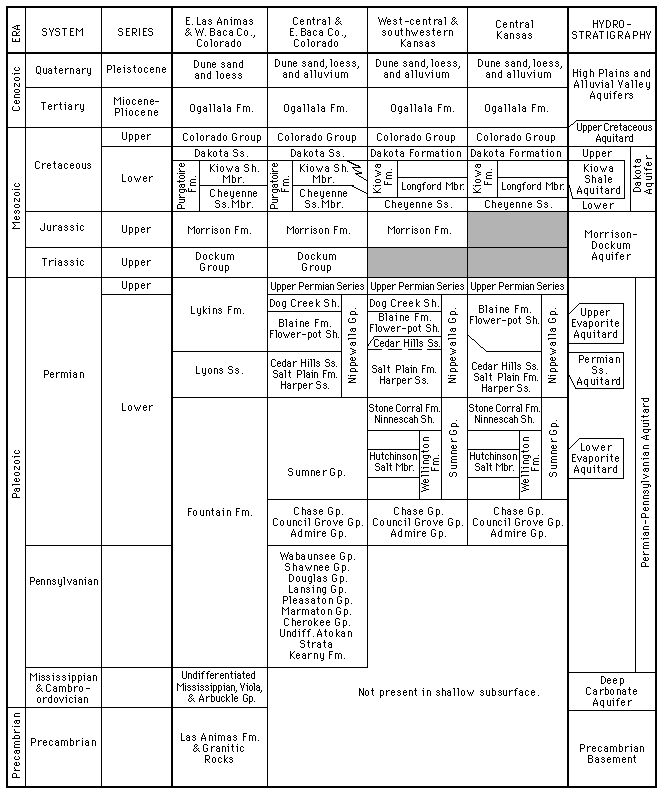
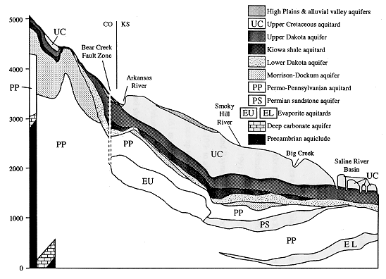
Figure 19--Hydrostratigraphy of the shallow subsurface
above sea level
in the vertical profile.
The Upper Cretaceous aquitard consists of a thick sequence of
rhythmically bedded chalky shale, massive limestone and chalky
limestone, dark-gray noncalcareous to calcareous shale and siltstone,
and thin seams of bentonite (Hattin, 1962, 1965, 1975, 1982; Hattin and
Siemers, 1987). Included in this part of the section are strata from
the Niobrara Chalk, the Carlile Shale, the Greenhorn Limestone, and the
Graneros Shale
(Table 3).
The upper Dakota aquifer consists of mudstones and lenticular very fine
to coarse-grained and conglomeratic sandstones belonging to the Dakota
Formation in Kansas and its stratigraphic equivalent in southeastern
Colorado, the Dakota Sandstone (McLaughlin, 1954; Franks, 1966, 1975;
Macfarlane et al., 1990; Macfarlane et al., 1991; Table 3). Sandstone
composes 30-40% of the aquifer framework regionally (Keene and Bayne,
1977), but locally the percentage of sandstone can range widely: from
less than 10% to almost 100% (Macfarlane et al., 1992). The thickness
of the upper Dakota aquifer ranges up to more than 350 ft (107 m) in
parts of west-central Kansas and to more than 200 ft (61 m) in Baca
County, Colorado.
Sediments belonging to the Dakota Formation and the Dakota Sandstone
were deposited in fluvial, coastal plain, deltaic, and shallow marine
environments in association with the developing Western Interior Sea
(Weimer, 1984). Fluvial channel sandstones were deposited in incised
valleys and in coastal plain settings in stacked fining-upward sequences
up to 100 ft in thickness (Hamilton, 1989; Macfarlane et al., 1991).
Finer-grained deltaic and shallow marine sandstones are present in the
upper part of the Dakota Formation and are generally much less than 100
ft (30 m) in thickness in central Kansas. However, deltaic deposits
make up most of the thickness of the Dakota Formation in western Kansas
and southeastern Colorado.
To gain insight into the functioning of the regional flow system, one
must know the head distribution in the major aquifer systems because
they are the main paths of transmission of ground water through the
system (Freeze and Witherspoon, 1967). The major aquifer systems in the
shallow subsurface of southeastern Colorado and western Kansas are the
High Plains and alluvial valley aquifers, the Dakota aquifer, the
Morrison-Dockum aquifer, and the Permian sandstone aquifer. The deep
carbonate aquifer is not included in this discussion because it is
present only in the shallow subsurface of southeastern Colorado. For
this discussion only the flow system in the upper Dakota aquifer is
discussed in detail because, outside southeastern Colorado and extreme
southwestern Kansas, the hydraulic head data are inadequate to fully
portray the flow system in the lower Dakota aquifer. However, the flow
patterns in the lower Dakota are believed to be similar to those in the
upper Dakota in most of Kansas.
Previous page--Regional Setting start ||
Next page--Flow Directions
Start of this report ||
Table of Contents
Kansas Geological Survey, Dakota Project
Updated Jan. 1997
Comments to webadmin@kgs.ku.edu
URL=http://www.kgs.ku.edu/Dakota/vol3/fy92/rep08.htm