Kansas Geological Survey, Open-File Rept. 93-1
Annual Report, FY92--Page 6 of 20
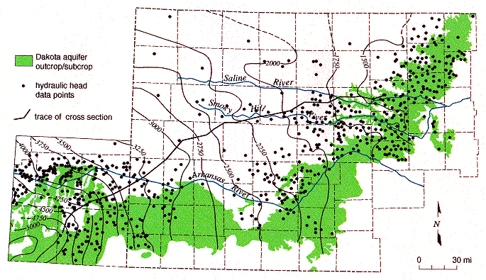
Darton (1905, 1906) describes the results of the earliest regional reconnaissance investigations into the hydrogeology of the Dakota aquifer in southeastern Colorado and adjacent parts of western and central Kansas. Darton reported numerous flowing wells in the Arkansas River valley and its tributaries in southeastern Colorado and in parts of central Kansas. He demonstrated that water enters the Dakota where it crops out at the surface south of the river, flows northeastward, and eventually discharges in central Kansas, where again the aquifer crops out at the surface (Figure 15). Using Chamberlin's (1885) concept of artesian aquifers, Darton believed that ground-water flow was controlled mostly by the head difference between recharge and discharge areas. Darton reasoned that the flowing wells in the Arkansas River valley and elsewhere in central Kansas could be accounted for only by (1) the elevated recharge areas south of the river and (2) the maintenance of artesian pressure in the Dakota from recharge to discharge areas by overlying Upper Cretaceous shales, referred to here as the Upper Cretaceous aquitard. Thus Darton described the Dakota as a classic example of an artesian aquifer.
Figure 15--Elevation in feet above mean sea level of the predevelopment potentiometric surface of the Dakota aquifer in southeastern Colorado and western Kansas.
More recent detailed hydrogeologic investigations have not supported Darton's conceptualization of flow in the Dakota. In a review of the literature, Helgeson et al. (1982) questioned the applicability of Chamberlin's (1885) concept to the Dakota on the basis of aquifer geometry and lateral hydraulic continuity. Others have found from regional flow models that factors other than the head difference between the recharge and discharge areas may influence ground-water flow in the Dakota and underlying aquifers. An aquifer is usually considered to be in good hydraulic communication with the overlying water table if there are only small head differences between them. In the Denver basin the Dakota is overlain by the Upper Cretaceous aquitard, which is as much as 10,000 ft (3,050 m) thick. In the basin and adjacent areas of eastern Colorado and western and central Kansas, Belitz (1985), Belitz and Bredehoeft (1988), and Helgeson et al. (1993) reported that heads in the Dakota and the deeper aquifers are in some cases more than 2,500 ft (760 m) lower than the head on the overlying water table. From regional flow models, they concluded that thick aquitards consisting of Upper Cretaceous shale and chalk severely restrict recharge to deeper parts of the flow system. Because of this, it appears that the head in the Dakota and the deeper aquifers is more responsive to the elevation of discharge areas to the east than to the head of the overlying water table in the basin.
In southeastern Colorado and in most of western Kansas the Dakota is within 1,000
ft (300 m) of land surface and the head difference between the water table and the Dakota is
less than 500 ft (150 m) (Helgeson et al., 1993). Thus heads in the Dakota are
subhydrostatic because they are significantly less than that of the overlying water table in
both the Denver basin and adjacent western Kansas. Heads in the deeper aquifers below
the Pennsylvanian are more than 2,000-3,000 ft (600-900 m) lower than heads in the
Dakota aquifer (Belitz and Bredehoeft, 1988; Jorgensen et al., 1993). This suggests (1)
that thick aquitards below the Dakota continue to restrict recharge to these deeper aquifers
eastward of the Denver basin and (2) that the Dakota aquifer hydrogeology changes
significantly between the basin and this part of the central Great Plains because of the
thinning of the Upper Cretaceous aquitard.
Revised Conceptualization of the Flow System
In this research, it is hypothesized that in this part of the central Great Plains steady-
state ground-water flow in the upper part of the regional system, including the Dakota
aquifer, is influenced primarily by (1) the Upper Cretaceous aquitard, (2) the Arkansas
River, and (3) the proximity of the confined Dakota to discharge areas in central Kansas.
The Dakota is an important component of the regional flow system because it is
hydraulically connected to all the major overlying and underlying aquifer systems and with
the overlying water table where it crops out at the surface in southeastern Colorado and
central Kansas. The Upper Cretaceous aquitard continues to restrict recharge to the Dakota
and underlying aquifers in western Kansas because of its thickness and low permeability.
In southeastern Colorado the Arkansas River valley is located downgradient of the primary
Dakota aquifer recharge area and removes some of the underflow that otherwise would
move into western Kansas. The loss of underflow diminishes recharge to downgradient
portions of the flow system in western Kansas and contributes to subhydrostatic heads in
the Dakota and other shallow aquifers below the Upper Cretaceous aquitard. The Saline
and Smoky Hill rivers have eroded through the Upper Cretaceous aquitard westward of the
main outcrop belt of the Dakota aquifer in central Kansas. This has effectively moved the
discharge area closer to the confined Dakota aquifer in western Kansas and thus contributes
to the observed subhydrostatic conditions (Belitz, 1985; Belitz and Bredehoeft, 1988).
The control exerted by the Upper Cretaceous aquitard on flow systems in the Dakota and underlying shallow aquifers is much less than in the Denver basin due to its reduced thickness. Within the last 10 million years differential uplift and intense local dissection of the High Plains surface by erosion have created considerable local and regional topographic relief (Gable and Hatton, 1983; Trimble, 1980; Osterkamp et al., 1987). Many of the rivers that cross the central Great Plains, such as the Arkansas, the Saline, and the Smoky Hill, have cut down through the aquitard and into the Dakota aquifer. High local relief favors the subdivision of the regional flow system into smaller subsystems, especially near river valleys (Toth, 1962, 1963; Freeze and Witherspoon, 1967). Consequently, the head difference between the Dakota aquifer and the overlying water table is reduced because of the proximity of the aquifer to the near-surface hydrologic environment. Helgeson et al. (1993) and Leonard et al. (1983) recognized a separate stronger flow component in the Dakota aquifer in this region that is not present in the Denver basin and emphasized the importance of cross-formational flow.
Regional investigations into the hydrogeology of the Dakota aquifer since Darton's time have shown that the head difference between regional recharge and discharge areas does not explain most of the observed head distribution in the aquifer. Darton (1906) believed that the only significant source of recharge was infiltrated precipitation entering the Dakota directly in southeastern Colorado. He did not recognize that the Upper Cretaceous aquitard could induce head losses in the underlying Dakota by restricting recharge. Neither Darton's work nor the later modeling studies reported by Belitz (1985), Belitz and Bredehoeft (1988), and Helgeson et al. (1993) address the influence of the Arkansas River and the Smoky Hill and Saline rivers on the flow system in the Dakota aquifer in western Kansas.
A significant drawback to the formulation of a fully calibrated model of the flow system in this research is that most of the available hydrologic properties and head data come from the upper part of the Dakota and other shallow aquifers and from much deeper hydrocarbon reservoirs in Permian and Pennsylvanian rocks. Because of this, the nature of the flow system below the Dakota and above these hydrocarbon reservoirs can only be surmised, and hence there is less information by which to calibrate the model. Fortunately, a fully calibrated model is not required when the purpose of the simulation is interpretive (Anderson and Woessner, 1992).
Accordingly, the objectives here are (1) to characterize the regional hydrogeology of the upper part of the regional flow system in southeastern Colorado and western and central Kansas, (2) to describe the construction of a vertical profile model of the upper part of the flow system, (3) to discuss the flow patterns in the partially calibrated steady-state model and the water budget, and (4) to present the results of sensitivity analyses that show the effect of the hydrostratigraphy and the river valleys on the flow system.