Kansas Geological Survey, Open-File Rept. 90-27
Annual Report, FY89--Appendix B
Use "Back" on your browser to return to the page you were viewing.
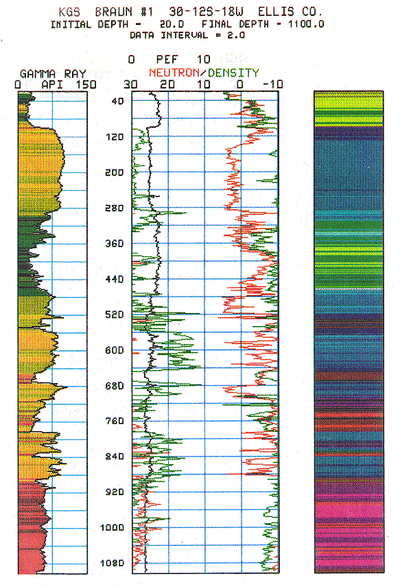
Figure B.1. Lithodensity, neutron porosity, and gamm-ray logs in KGS #1 Braun NE-NE-NE 30-112S-18W, Ellis County, Kansas.
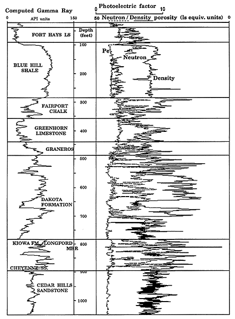
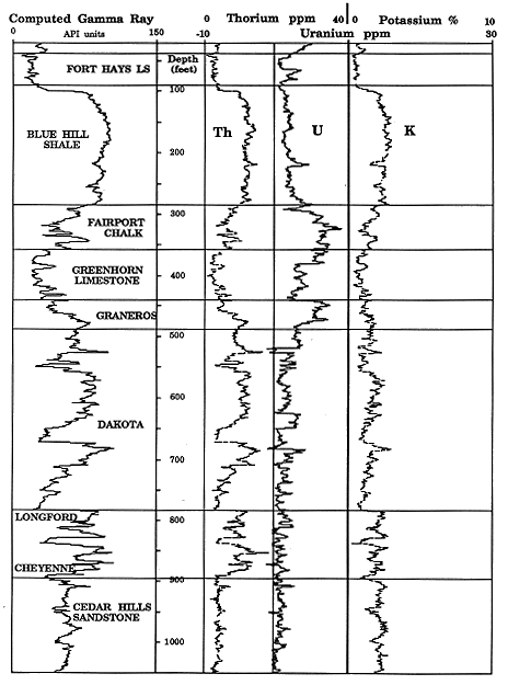
Figure B.2. Spectral gamma-ray (thorium, uranium, potassium) logs in KGS #1 Braun NE-NE-NE 30-12S-18W, Ellis County, Kansas.
The modern geophysical logs of this program are a major source of new information on properties of the Dakota Formation for several reasons. Many of the older holes which penetrate the Dakota were logged by simple wireline tools, with applications restricted to stratigraphic correlation, discrimination of sandstones and shales, and the generalized interpretation of profiles and trends. Even in cases where sophisticated modern logs have been run in deeper tests, most of these logs were not recorded at depths shallower than the Permian Stone Corral Formation.
An important contribution made by some of the newer logging measurements is that they can be linked directly with a range of geological properties. They are responses to geochemical variability, and so can be interpreted with more ease than older logs, which are primarily electrical and so only oblique indicators of factors such as facies or compositional changes. At the same time, interpretation techniques for "wireline geochemical data" are also an area of active research. Consequently, these log analyses of the Dakota break new ground, not only as geological applications but in the development of new interpretation methods. Initial results of new efforts have already been published by Macfarlane, Doveton and Coble (1989) and Collins and Doveton (1988, 1989).
In the following sections, a detailed log analysis is described for the initial test borehole, KGS #1 Braun that parallels the methods applied to logs of the later test holes and is consistent with the analytical results of processing these logs.
Table B.1. Formation tops the #1 KGS Braun well from the driller's log.
| Formation | Member | Depth (below l.s.) |
Altitude (m.s.l.) |
|---|---|---|---|
| Niobrara Chalk | Smoky Hill Chalk | ||
| Fort Hays Limestone | 35 | (2105) | |
| Carlile Shale | Codell Sandstone | 88 | (2052) |
| Blue Hill Shale | |||
| Fairport Chalk | 284 | (1865) | |
| Greenhorn Limestone | 360 | (1780) | |
| Graneros Shale | 435 | (1705) | |
| Dakota Formation | 488 | (1652) | |
| Longford/Cheyenne | 784 | (1356) | |
| Cedar Hills Sandstone | 897 | (1243) | |
| Total Depth | 1197 | (943) |
The potassium-thorium crossplot is now widely used as an aid in the recognition of clay mineral associations and the discrimination of micas and feldspars. A crossplot of digitized log data (sampled at the standard rate of two readings per foot) from the Cedar Hills Sandstone, and Cretaceous formations is shown in Figure 8.3 and uses the chartbook crossplot scale conventions (Schlumberger, 1986). The lines which radiate from the origin have gradients matched with values of Th/K ratios which have proved useful in the broad distinction of radioactive minerals marked on the plot.
Figure B.3. Crossplot of potassium and thorium in Permian and Cretaceous formations in KGS #1 Braun NE-NE-NE 30-12S-18W, Ellis County, Kansas. The top figure shows a composite of all data; the lower figure graphs elliptical templates for location of cloud subdivisions matched with each stratigraphic unit.
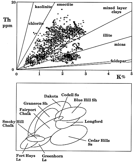
The cluster of points from the Cedar Hills Sandstone is clearly separated from Cretaceous zones and is readily interpreted as a quartz-feldspar-illite system. This aspect conforms very well with the petrography of this unit. Holdoway (1978) made a detailed examination of core from a test well in Wichita County and described the composition of the Cedar Hills Sandstone as ranging from quartz arenite to lithic subarkose. The sandstone samples contained quartz grains which were commonly coated with hematite, between 5 and 10 percent of fresh feldspars which often showed microcline twinning, small amounts of rock fragments derived from felsic intrusives, opaque minerals and traces of authigenic clays. The sandstones were unusual in that they were frequently halite cemented. Although Holdoway (1978) made no analyses of clay minerals in the Cedar Hills, James (1972) reported chlorite-vermiculite and illite from the insoluble residues of the immediately overlying Flowerpot Shale.
The Cretaceous strata below the Graneros shale plot as a broader and more diffuse cloud, as would be expected for a mixed sequence of sandstones, siltstones and shales. However, the cloud is coincides with the kaolinite-smectite-illite range of Th/K ratios which, once again, shows excellent agreement with known petrography. Merriam et al (1959) made the most detailed compositional analysis of the Lower Cretaceous formations and Graneros Shale in their study of a lengthy core from Cheyenne County. They found that the matrix of the sandstones was dominantly quartz with traces of feldspar, chert, schist fragments and detrital tourmaline. The shales are mostly a mixture of illite and kaolinite with subsidiary amounts of chlorite, smectite, and mixed-layer clays. Smectite became a major component in the overlying Graneros Shale. Crossplot data from the Graneros Shale overlaps the Lower Cretaceous points. However, there is a distinctive bias towards higher Th/K ratios, which probably reflects the increased importance of smectite as a significant component. The source of much of the smectite can probably be attributed to bentonite (altered volcanic ash) horizons observed in this borehole (see Figure B.5). Other Upper Cretaceous units show a common trend of a slightly more potassium-rich ratio suggestive of a normal composition, dominated by illite.
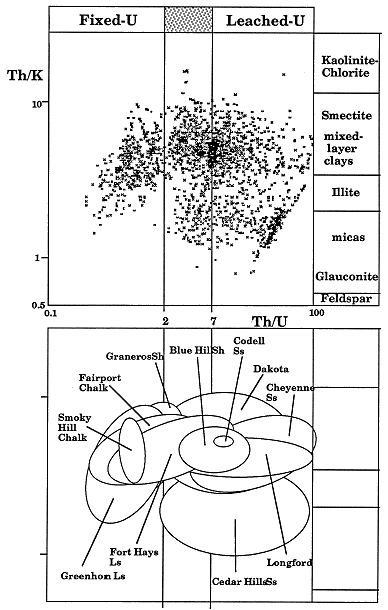
The thorium-uranium ratio (Th/U) has also proved to be useful in the recognition of "geochemical facies". The Th/U ratio is an indicator of redox-potential. Uranium has an insoluble tetravalent state that is fixed under reducing conditions, but is transformed to the soluble hexavalent state which may be mobilized into solution. In contrast, thorium has a single insoluble tetravalent state which is geochemically associated with uranium and is therefore a useful standard for comparison purposes. In a pioneer paper, Adams and Weaver (1958), concluded that the Th/U ratio was often strongly linked with depositional environment, based on their laboratory analysis of many samples of differing lithologies. They suggested that when the ratio was computed to be less than two (i.e. uranium-rich), the depositional environment had promoted uranium fixation under probable reducing conditions, and was most commonly marine. By contrast, ratio values of greater than seven (uranium-poor), implied uranium mobilization through weathering and/or leaching, and therefore indicated an oxidizing, possibly terrestrial environment. Zelt (1985) made gamma ray spectral measurements of Upper Cretaceous outcrops in Colorado, Utah and New Mexico and showed relationships between the Th/U ratio and transgression-regression cycles as well as inferred distance from shoreline. He found that anomalous ratio values could be correlated regionally between outcrops and on spectral logs from the subsurface and suggested that they were related to major changes in oxygenation and/or salinity in the Western Interior Seaway.
A crossplot of Th/U and Th/K ratios (Figure B.4) summarizes compositional changes related to potassium as well as implications concerning redox potential. Permian and Lower Cretaceous units appear to have been deposited in oxidizing or neutral environments. These contrast with the reducing to neutral conditions which characterize the Upper Cretaceous strata.
Figure B.4. Crossplot of thorium-potassium and thorium-uranium ratios in Permian and Cretaceous formations in KGS #1 Braun NE-NE-NE 30-12S-18W, Ellis County, Kansas. The top figure shows a composite of all data; the lower figure graphs elliptical templates for location of cloud subdivisions matched with each stratigraphic unit.
The Th/K and Th/U ratios were also plotted as logs in the Braun #1 well together with the gamma ray trace and a graphic lithology log from the description of drill cuttings (Figure B.5). The simultaneous consideration of these data throughout the sequence reveals striking and readily interpretable patterns. An abrupt shift occurs at the Cretaceous-Permian contact and highlights clearly the major basal Cretaceous unconformity. The illite-feldspar signature of the Cedar Hills Sandstone changes to a Lower Cretaceous trace which oscillates between illitic and kaolinitic clay minerals facies, possibly linked with marine and deltaic fresh-water environments, respectively. Fluctuations in the Upper Cretaceous units appear to pick up changes in illite, smectite and mixed-layer clays as products of predominantly marine environments and these are the clay mineral components reported in x-ray diffraction analyses of insoluble residues (Arthur et al, 1985). The high amplitude variations in the Graneros Shale and Greenhorn Limestone may reflect the occurrence of bentonites (observed in the drill cuttings) interbedded with normal illitic marine shales. These bentonites represent altered ash deposits generated from explosive events from volcanoes in the Idaho-Montana and New Mexico-Arizona regions (Kauffman, 1985).
Figure B.5. Gamma-ray, lithology (from well-cutings), and spectral gama-ray ratio logs in KGS #1 Braun NE-NE-NE 30-12S-18W, Ellis County, Kansas.
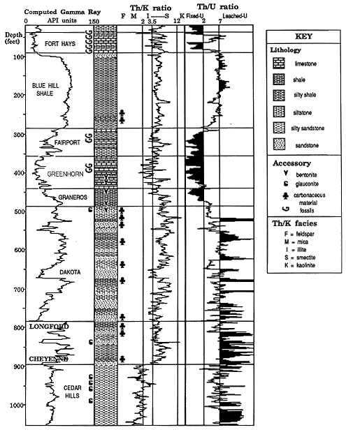
The Th/U ratio log was indexed with the diagnostic values of 2 and 7 suggested by Adams and Weaver (1958) to aid depositional environment interpretation through its use as an oxidation potential indicator. The ratio indicates an oxidizing environment for much of the Cedar Hills Sandstone, which would be expected from its postulated origin as eolian sands (Holdoway, 1978). The occurrence of glauconite in drill cuttings from the upper part of the formation is a strong indicator of marine origin and is matched by a decline in the ratio to a neutral range. This section may reflect deposition in shallow bodies of water linked with an ephemeral sea, as suggested by Holdoway (1978) for the Flowerpot Shale.
The overlying undifferentiated Kiowa-Cheyenne marks a transgressive phase and is generally considered to be represented by a marine environment in Kansas (Merriam, 1959). In the Braun #1 well, this unit is represented by the Longford Member which is the lateral, more paralic equivalent of the more marine Kiowa. The Th/U ratio log exhibits a high-frequency character in the lower part of the undifferentiated Kiowa-Cheyenne, but is consistently higher than 7 in value and so is consistent with an oxidizing terrestrial environment of alluvial sediments. The average Th/U ratio in the upper part of the undifferentiated Kiowa-Cheyenee is lower than in the lower part, but shows only a weak trend to the intermediate range. This feature is a pale shadow of the strong signals in the spectral ratio of Upper Cretaceous transgressions in this well. However, the subdued character is in concordance with a paleogeographic map of peak transgression in the Kiowa (Vuke, 1981), which shows the wellsite close to shoreline.
Stacked repetitions of high and medium Th/U ratios characterize the Dakota Formation. These probably reflect high lateral variability in clastic facies and interplay between mostly brackish and fresh-water regimes of distributary channels, bays and marginal marine deposits, which would be expected to typify a delta complex.
The relatively smooth, long-term cyclic pattern of the Th/U ratio in the marine sequence of the Upper Cretaceous is in stark contrast to the high frequency character of the ratio in the deltaic deposits below, and is an excellent indicator of a broad transgression/regression couplet on an open marine shelf. In fact, the broad sine-wave feature conforms precisely with the outcrop interpretation of the Greenhorn Cycle as a classic example of a symmetric, third-order tectonoeustatic cycle (Glenister and Kauffman, 1985). Hattin (1985) was able to correlate demonstrably time-parallel beds in the Greenhorn from outcrops in Kansas to locations in Colorado and New Mexico. He concluded that the exceedingly widespread deposition of relatively thin units implied a regionally flat, gently sloping sea-floor. The model would account for the strong simple transgression-regression signal in the ratio log from the top of the Dakota to the base of the Niobrara. The transgressive phase of the cycle started in the uppermost part of the Dakota formation, continued through the Graneros Shale, and reached maximum development in the Greenhorn Limestone. The regressive hemicyclothem was initiated at the top of the Greenhorn and continued through the Fairport Chalk and Blue Hills Shale, to terminate in the Codell Sandstone.
There is an abrupt break in the Th/U ratio log at the boundary between the Codell Sandstone and the overlying Fort Hays Limestone member, Niobrara Chalk. This contact is thought to represent a long period of non-deposition followed by a major transgression (Hattin and Siemers, 1978). The ratio log shows this transgression clearly, but also indicates a distinctive regressive event at the top of the Fort Hays. This anomaly coincides closely with a similar peak on a Th/U log from a Colorado well observed by Zelt (1985), who attributed it to a regional warm water pulse or low salinity event suggested from oxygen isotope studies in the carbonate phase.
The recent introduction of the photoelectric factor as a supplementary curve to the conventional neutron and density logs has improved substantially the log recognition of mineralogy. The display of lithodensity-neutron logging data on a RHOMAA-UMAA crossplot is the most direct means to ascertain rock compositions from this log combination (McCall and Gardner, 1982). RHOMAA is the hypothetical density of the rock matrix computed as the projection of the rock's bulk density which eliminates the effect of the fluids in the pore space. UMAA is the theoretical volumetric photoelectric absorption index of the matrix, calculated from the photoelectric factor using similar considerations.
A RHOMAA-UMAA crossplot of digitized data from Braun #1 is shown in Figure 8.6. The plot is indexed with the locations of quartz and calcite set by their densities and aggregate atomic numbers. The data cloud can be seen to consist of two distinctive subsets. One emanates from a tight cluster around the quartz point, as a trend to higher values of RHOMAA and UMAA associated with shale. This cloud ranges from sandstones, through siltstones to shales, where the location of each point is controlled by the amount of quartz, and the volume and compositions of clay minerals. The other trend is linked with limestone-shale mixtures which also characterize the chalks and marls of this sequence. This trend is more diffuse because quartz silt is an additional component.
Figure B.6. Crossplot of apparent matrix density (RHOMAA) and apparent matrix photoelectric absorption (UMAA) in Permian and Cretaceous formations in KGS #1 Braun NE-NE-NE 30-12S-18W, Ellis County, Kansas. The top figure shows a composite of all data; the lower figure graphs templates for location of cloud subdivisions matched with each stratigraphic unit.
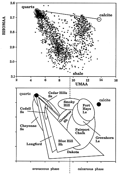
A partition line set at a UMAA value of 9.5 separates the two trends effectively, and the resulting two crossplot fields were named informally as "arenaceous phase" and ""calcareous phase" (see Figure B.6). The clastic sediments of formations of the Permian and Lower Cretaceous plot as triangular-shaped clouds in the arenaceous phase, whose upper vertex points towards quartz. By contrast, most of the Upper Cretaceous units from approximately ellipsoidal clouds in the calcareous phase. The important exceptions are provided by the Blue Hill Shale and Codell Sandstone, which both plot in the arenaceous phase.
The relationships described here were clarified further through the plot of a UMAA log to highlight depth-related trends (Figure B.7). A comparison of the gamma ray and UMAA logs in the Dakota Group show both similarities and contrasts, which reflect their different sensitivities to feldspars and clay minerals. These relationships will be considered in more detail in the next section. The UMAA log in the Upper Cretaceous appears to be a highly diagnostic indicator of both lithofacies and sedimentation history.
Figure B.7. Log of apparent matrix photoelectric absorption (UMAA) indexed with arenaceous phase" and "calcareous phase" classification value developed from crossplot of Fig. B.6, KGS #1 Braun NE-NE-NE 30-12S-18W, Ellis County, Kansas.
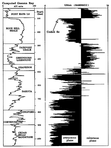
The lower part of the Graneros Shale appears to consist of silty shales of the arenaceous phase which switch abruptly to limestones and calcareous shales in the upper part. The calcareous phase aspect is maintained by a busily fluctuating log trace through the succeeding Greenhorn Limestone and Fairport Chalk. At the boundary with the Blue Hill Shale there is a rapid transition to the arenaceous phase. The striking contrast in UMAA log character between the Fairport and the Blue Hill matches observations from well cuttings where "the Fairport is very calcareous, and the Blue Hill only slightly calcareous, if at all "(Merriam, 1963, p. 51). In the lower part of the Blue Hill Shale, the log suggests a fairly constant silt composition, but this changes in the upper part with an apparent acceleration in increasing quartz content, terminating with the Codell Sandstone. The same character is seen in nearby outcrop where, "towards the top of the Blue Hill the quantity of terrigeneous sand and silt increases markedly" (Hattin, and Siemers 1978, p. 40). The UMAA log response of the Codell is the most quartzose of the Upper Cretaceous section and reflects its nature as a well-sorted fine sand/coarse silt. The contact of the Fort Hays with the Codell is marked on the UMAA log by an abrupt switch to the calcareous phase. The sudden transition coincides with the Carlile-Niobrara unconformity.
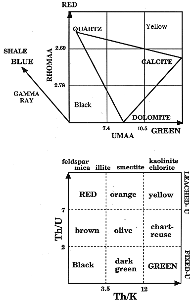
Briggs (1985) introduced the concept of the color cube as a reference system for the simultaneous display of several logs. His model used the three primary colors of red, green and blue. When the three primaries are made sources of light, then their mixing obeys additive rules. So, for example, red and green combined together generate yellow, as would be seen in stage lighting, and contrasts with the brown that results from mixing of red and green paint pigments which follow subtractive rules. By arranging red, green and blue as three orthogonal axes, a spectrum of hues is generated in three dimensional space (Figure B.9). At the origin of the axes, the primary colors have no value and the result is darkness or "black." At the maximum value on all three axes, the equal blending of the primaries results in white light. All other locations in the framework will be matched with distinctive hues which are immediate visual information of three coordinate values.
If the color axes are equated with logs, the color cube is the framework for a three-dimensional crossplot. As an illustrative example, Briggs (1985) chose sonic, gamma ray and resistivity logs as color cube axes. When applied to a logged section, the crossplotted points formed clusters which were differentiated from one another by their change in hue. The hue assigned to each zone was then played back as a sequence ordered in depth to generate a color strip log. The result was a color image transformation, where shale zones were differentiated and potential hydrocarbon zones highlighted in a striking manner.
Collins and Doveton (1986) named the color cube presentation of logs as the "Briggs cube" in honor of their originator and explored new ways of working with the cube that would incorporate standard log analysis concepts. Rather than work with the cube as a continuum of color, they elected to subdivide the cube into a set of discrete cells. The planes between layers of cells would be chosen to coincide with distinctive coordinate values that marked the boundaries between reference minerals, levels of porosity, or shale content. Used in this manner, the cube operates as an automatic classification device with explicit meanings assigned to cell hues. Also, the choice of axis designation would not be restricted to raw logs, but could include variables that were themselves arithmetic combinations of several logs.
The RHOMAA-UMAA crossplot (Figure B.6) was matched with red and green color axes (see Figure B.8). To aid interpretation, a square in this color coordinate plane was divided into nine color hue cells whose boundaries were chosen to subdivide the fundamental calcite-quartz-dolomite triangle into reasonably equant subareas. Sandstones are signified by red, limestones by "chartreuse," and dolomites by dark green. Although the design is geared to the most common non-shale lithologies, other minerals will have characteristic colors. So, for example, anhydrite beds will be bright green, while halite will be yellow. The introduction of the gamma ray log as the blue axis completes the cube and equates the blue component with shale effects. The hues associated with shales are more variable and result from the interplay of several factors. In general, the degree of "blueness" reflects the proportion of clay minerals, allowing discrimination of shales, silty shales and shaly sandstones. Shaly facies of the "calcareous phase" will tend to have a higher additive of the green component than shales of the "arenaceous phase." However, the UMAA variable is also sensitive to distinctions between clay mineral species (as will be described in the detailed analysis of the Dakota). Consequently, the green content is also influenced by compositional variation of kaolithic, smectite illite and chlorite.
Figure B.8. Color cube convention for RHOMAA-UMAA-Gamma-ray logs (above) and color-square classification of spectral gamma-ray ratios (below).
The RHOMAA-UMAA-gamma ray color cube was used to transform the lithodensity-return-gamma ray log profile of Braun #1 into a single color image log. The result is shown in Figure 8.9, where the logs are graphed in conventional format, and the color image log is positioned as a strip log to the right. For reasons of economy, the color image is reproduced in this report in black and white, but the full color rendition is published in Collins and Doveton (1989). The following description summarizes observations concerning the actual color image, which shows striking color patterns. The Permian Cedar Hills Formation is magenta red and dark magenta with subsidiary brown and red bands and highlights sandstones which range from quartz arenites to subarkoses. At the basal Cretaceous unconformity there is an abrupt change to bandings of browns, dark blues and dark cyan in the deltaic deposits of the Dakota Group and reflect sandstones and shaly sandstones interbedded with illite-kaolinite shales. Above the Dakota Group, the marine Greenhorn cyclothem is marked by "chartreuse" Greenhorn limestone beds, green marls and dark cyan shales. At the top of the sequence, the Fort Hays limestone of the Niobrara formation is picked out by a thick chartreuse-colored feature.
Figure B.9. Color cube transformation of gamma-ray lithodensity logs as image-strip log (at right) and color-square rendition of spectral gamma-ray logs (as infill to gamma-ray log at left).
The spectral gamma ray logs were used to generate a second color image log through the application of a "color square" to the spectral ratio crossplot (Figure B.4). The crossplot axes were matched with the color primaries of green and red (Figure B.8) and subdivided into nine cells to form a color square. The two cell boundaries on the Th/U ratio axis correspond to the critical values advocated by Adams and Weaver (1958). The column boundaries are more arbitrary, but were selected from gradients on the standard potassium-thorium crossplot to subdivide mineral associations into three approximately equant fields. The colors and resulting cell hues were carefully selected to mimic "natural" colors and so aid pattern recognition on color transform logs. Values of high Th/U (implied oxidation) correspond to the cell hues of yellow, orange and red. These are the colors of oxidized ferric iron which commonly colors rocks of this facies. Low values of Th/U (implied reduction) generate cell hues ranging from black through dark green to bright green, which are the colors of reduced ferrous iron as seen in green and black shales. Color assignments with respect to the Th/K ratio are less clear-cut, but the convention used often matches rock color.
A procedure similar to that used on the lithologic color cube was applied to the generation of a color strip log from the spectral ratio color square. Digitized values of the thorium, uranium and potassium logs are condensed to Th/K and Th/U ratios at each depth increment. By reference to cell boundaries within the color square, a color hue is assigned to each increment and the cumulative results displayed as a color image log in order to accommodate the statistics of the spectral log measurements. For zones with high counts of the individual radioactive sources, the ratios are not unreasonable estimates of their real values, especially when taking into account the coarse classification of the color square. However, at lower levels the ratios are poor estimates which may fluctuate wildly as a consequence of the stochastic nature of the measurement and the poor statistics associated with the small count samples. Consequently, the color image log was generated as a color fill within the trace of the gamma ray log. By this means, the image is automatically and graphically scaled in strength by the total sample size traced out by the gamma ray curve.
The spectral gamma ray log in Braun #1 was transformed to a color image, shown as a fill within the gamma ray log at the left of Figure B.9. As before, the colors that are masked by this black and white rendition will be described and interpreted. The eolian feldspathic sandstones of the Permian Cedar Hills are dominantly red with subordinate brown bands. The sandstones and illite-kaolinitic shales of the Lower Cretaceous Dakota Group deltaic deposits are colored orange and olive. The marine beds of Lower Cretaceous shales and limestones follow a color sequence which tracks with the transgression-regression history of the Greenhorn Cyclothem. Initial transgressive shales are dark green, changing to black at maximum transgression. The Niobrara, at the top of the succession, marks a a new transgressive deepening cycle and is matched by dark green.
The RHOMAA-UMAA plot of Figure B.10 is restricted to data from the Dakota aquifer formations. The plot shows a distinctive triangular wedge pattern, whose upper vertex is highly focussed on the theoretical quartz point. The wedge diverges downwards to a shale facies represented by the base of the triangle. Although the shale has a restricted variation of apparent density, between 3.0 and 3.1 gm/cc, the range of 7 to 14 barns/cc in UMAA value, reflects compositional changes of clay minerals. The UMAA variable is a direct, but non-linear, function of the aggregate atomic number (Z) of the rock matrix. The wedge-shaped data cloud therefore represents a composition triangle whose vertex extremes are quartz, "low-Z shale" and "high Z shale" (Figure B.10). The approximate locations of idealized clay minerals are marked on the figure, based on Schlumberger (1986) data. These serve as a general guide to the potential meaning of compositional trends, although the extremes of the clay mineral variation precludes more precise analysis.
Figure B.10. Crossplot of apparent matrix density (RHOMAA) and apparent matrix photoelectric absorption (UMAA) in the Dakota aquifer formations of KGS #1 Braun.
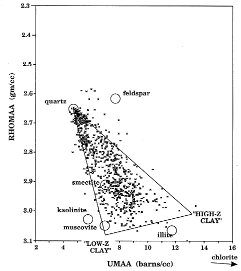
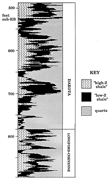
According to Ellis (1987), changes in the photoelectric absorption in shales can be attributed almost entirely to iron content. This is because, in the absence of iron, the Pe of the aluminosilicate clays would be difficult to distinguish from sands. The shales with higher values of UMAA indicate the presence of significant amounts of iron-bearing clay minerals. These are most commonly illite and (especially) Fe-chlorite, which contrast with smectite and kaolinite, with little or no iron. The data range between values for quartz low-Z clays (kaolinite, smectite, and muscovite) and high-Z clays (illite and chlorite), and can be represented reasonably by a composition triangle. Any single point on the plot may then be recast as proportions of the three end members. The RHOMAA-UMAA data for the Dakota aquifer formations were transformed to a proportional log of these three components by a matrix algebra computer algorithm described by Doveton (1986). The compositional log profile (Figure B.11) shows distinctive, if complex, patterns. The "shaley" phase of sandstones is consistently dominated by the low-Z component, which probably reflects kaolinite and/or mica. The shales between the sandstones show a variable interplay between the two shale endmembers, in which the high-Z component may be linked with transgressive phases.
Figure B.11. Compositional log profile of Dakota aquifer formations in terms of "low-Z shale," "high-Z shale," and quartz, established from RHOMAA-UMAA crossplot (KGS #1 Braun).
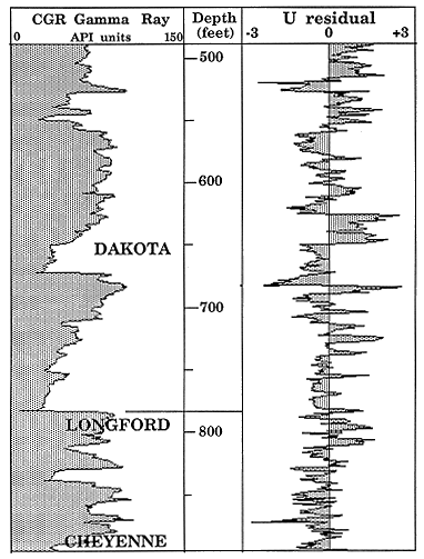
The Th/U ratio appears to be a useful indicator of redox potential, but its utility is often hampered by the relatively low uranium count in much of the Dakota Aquifer formations. As a result, the rapidly fluctuating Th/U ratio log trace in the Dakota (Figure B.5) is partly caused by the low values of the denominator. In an alternative method to locate apparent uranium anomalies (both high and low), uranium in the Dakota was made the subject of a regression analysis. A least squares equation for uranium was calculated in terms of RHOMAA, UMAA, neutron porosity, thorium and potassium. As a prediction equation, the relationship was determined to be highly significant by an F-test. A particularly interesting aspect of the analysis was that the contribution of the variables to uranium prediction was dominated by the RHOMAA variable. By contrast, potassium and thorium made minor :(and even slightly negatively-signed) contributions.
As will be described later, the RHOMAA variable seems to be the single most important description of quartz sand/silt content. This predictive link with uranium implies that the dominant control is grain size. Uranium is preferentially concentrated in fine grained deposits at greater distances from clastic sources and may be either marine or localized non-marine facies on the delta plain.
Although the regression relationship is statistically significant, 67% of the total variation is contained in deviations from the trend. A log plot of the uranium regression residuals (Figure B.12) highlights anomalies, which represent zones where uranium is either higher or lower than would be expected from other log responses. In the KLC unit, the anomalies show a high-frequency alternation of low-uranium zones, which changes to a positive anomaly in the upper Kiowa. Within the Dakota Aquifer formations, the residuals tend to show broader changes, whose meaning is difficult to establish at this time. A major reason for this is that relative uranium enrichment or impoverishment can be attributed not only to redox potentials of depositional environments but also other causes. The sandstones can form conduits for uranium- bearing waters so that concentrations may be controlled or modified by hydraulic transport-fixation mechanisms, such as described by Cowart and Osmond (1977).
Figure B.12. Residual differences netween uranium content and auranium predicted from a multiple regression based on RHOMAA, UMAA, neutron porosity, thorium, and potassium in the Dakota aquifer formations of KGS #1 Braun.
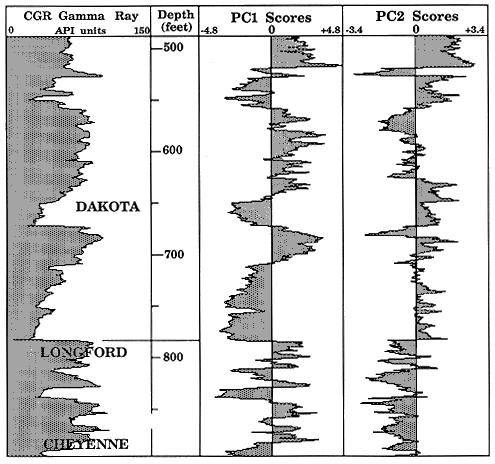
The statistical method of principal components was used to investigate the interrelationships of RHOMAA, UMAA, neutron porosity, thorium, uranium and potassium in the Dakota aquifer formations. Principal components are eigenvectors of the covariance matrix of input analytical variables. For non-statisticians, they are most easily understood as the principal axes of the data cloud plotted in the multidimensional space of the input variables. The method ensures that the components are ordered in importance, such that the first principal component accounts for the major source of variation, and the others pick up successively smaller proportions. In this application, there are six input log variables so that the total variation will be completely described by six principal components. Rather than compute principal components of the raw data, the variables were standardized ( zero mean, unit standard deviation ) to eliminate the influence of widely differing scales of measuremen . The principal components are now the eigenvectors of the correlation matrix . The method is very useful as a means to condense multivariate data sets to a few descriptive variables. Their "meaning" can often be deduced by inspection of their loadings with respect to the input variables.
The principal components of the log set and their loadings are listed in Table B.2, together with their contributions. The first principal component accounts for 59% of the total variation, which indicates a high degree of intercorrelation between the variables, and so, information redundancy. This component has moderate positive loadings with respect to all logs and so appears to be identified as a composite "shale component". The loadings represent coefficients which can be used to transform any zone set of six log readings to a single "score". The score is the distance of the data point along the axis of the principal component which is angled with respect to the input variables, as dictated by the loadings. As scores can be computed for any zone, a sequence of zone scores constitutes a "principal component log". In Figure B.13, the first principal component is now clearly identified as a shale log by its close mimicry of the gamma-ray log. This result is to be expected, since the difference in properties of clay mineral from non-clays will be the most pronounced matrix feature with respect to all logs. The remaining principal components may therefore be considered to reflect other factors that are largely independent of bulk volume shale variation.
Table B.2. Principal components of logs in the Dakota aquifer formations
| PC1 | PC2 | PC3 | PC4 | PC5 | PC6 | |
|---|---|---|---|---|---|---|
| RHOMAA | 0.50 | 0.06 | 0.05 | -0.16 | -0.16 | -0.83 |
| UMAA | 0.45 | -0.05 | -0.08 | -0.78 | 0.04 | 0.91 |
| Neutron | 0.39 | 0.36 | 0.72 | 0.25 | 0.32 | 0.20 |
| Thorium | 0.44 | -0.30 | 0.00 | 0.38 | -0.64 | 0.30 |
| Uranium | 0.27 | 0.67 | -0.63 | 0.25 | 0.07 | 0.13 |
| Potassium | 0.35 | -0.57 | -0.28 | 0.29 | 0.62 | -0.02 |
The second principal component accounts for 19% of the total variation, and shows positive loadings of neutron porosity and uranium, versus negative loadings of thorium and potassium. Interpretation is more problematical, but is aided by the second principal component score log shown in Figure B.13. The log shows the Cheyenne-Longford to be almost entirely negative, in contrast to the Dakota Aquifer, which is dominated by positive scores. There appear to be a mixture of processes which collectively account for this differentiation. One aspect is the higher level of potassium in the Cheyenne-Longford unit relative to the Dakota, while the Dakota has intervals which have higher uranium, particularly in the uppermost part.
Figure B.13. Scores of first two principal components plotted as "logs."
A crossplot of the first two principal component scores (Figure B.14) which can be thought of as a plane which crosses six-dimensional space and accounts for 78% of the total variation. Three "electrofacies" were located empirically in the data cloud to differentiate extremes in the ranges of the principal components, and which appear to be associated with natural clusters. Facies A and B are both shale types, which have positive and negative second principal component scores, respectively. Facies C corresponds to the quartz matrix. The linkage of the three facies as vertices of a composition triangle enabled the computation of the composition profile of Figure B.15. Future work on the clay-mineral composition of selected samples by X-ray diffraction methods will provide the necessary groud-truth for detailed interpretation of the distinctive features of this profile.
Figure B.14. Location of electrofacies on crossplot of first two principal components.
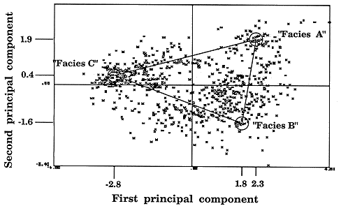
Figure B.15. Composition profile of three electrofacies located on crossplot of first two principal components.
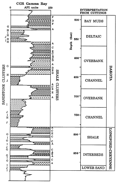
As used here, the method of principal components is most useful in the condensation of multivariate data into a few compound descriptive variables. The result is a mapping into a lower dimensional space where the data distribution appears to show localized clusters. In a more direct method, which retains the six-dimensional framework of the raw variables, zones were clustered by Ward's method. Inspection of the output indicated that there were ten distinct clusters whose interrelationships are shown in the dendrogram of Figure B.16. Comparison of the zones and their cluster classification with environmental interpretation from cuttings (Figure B.17) allowed some generalized meanings to be assigned to the clusters. There is a distinct bifurcation between shale clusters ( A to F ) and sandstone clusters ( G to J ). Clusters A to D are different floodplain facies, although there is considerable overlap with paralic facies. Facies F is clearly identified with the bay mud facies that immediately underlies the Graneros Shale. Facies E is closely related to F and may also represent bay mud or paralic facies. In the sandstone group, there is some ambiguity in cluster meaning, since the controlling variable appears to be grain-size. However, G and H are more commonly associated with deltaic facies, and I and J with channel facies. Cluster J probably reflects coarsest grain-size and may differentiate upper meander belt facies from lower meander belt facies of cluster I.
Figure B.16. Dendrogram of ten principal facies located by cluster analysis and based on RHOMAA, UMAA, neutron porosity, uranium, and thorium.
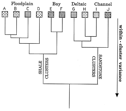
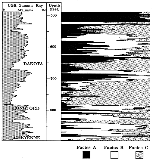
Figure B.17. Cluster classification of zones in the Dakota Aquifer, KGS #1 Braun.
Fourier analysis was made of the computed gamma-ray log in the Lower Cretaceous section to check for any systematic cyclic components. The power spectrum (Figure B.18) shows a strong periodic character to the data . Three major harmonics dominate the total variability and have estimated wavelengths of 102, 58 and 29 feet which form a simple multiple sequence. A playback of a synthetic gamma-ray log composed of the mean and the three harmonics (Figure B.18) shows a close representation of the major features of the raw log. As discussed earlier, a number of log characteristics show the transgression-regression couplet of the Greenhorn cyclothem in a striking manner. The results of the Fourier analysis suggest that eustatic and/or tectonic events may not only be evident in marine sequences, but also influence the distribution of shale and sand within the ancient delta complex. Additional Fourier analyses will be made of Dakota sequences in other Kansas wells to investigate this initial speculation. If the periodic character persists as a regional phenomenom, this may be useful in correlation of event stratigraphy as well as interpretations of basin development.
Figure B.18. Discrete power spectrum of computed gamma-ray log in the Dakota aquifer and the sine-wave signitures of the three principal harmonics.
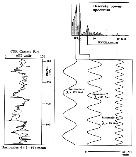
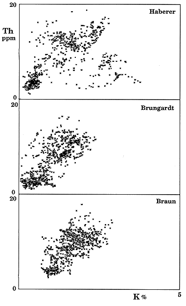
Figure B.19. Potassium-thorium crossplots of the Dakota aquifer section, ranging from KGS #1 Braun in the west through Brungardt to KGS Haberer in the east.
An environmental facies subdivision based on drill samples was used earlier to interpret the meaning of zones grouped by cluster analysis. A similar procedure was used to classify intervals based on both stratigraphy and evidence from drill-cuttings in Brungardt #1 and core from Haberer #1. Facies of the Dakota Aquifer formations were allocated between bay (B), deltaic (D), overbank (O) and channel (C). The facies classification of the Cheyenne - Longford unit was based more on a stratigraphic subdivision, with a lower sand (L) succeeded by a division of interbeds (I), and capped by a Kiowa-Longford shale facies (S). The mean values of potassium and thorium for intervals of these facies are shown as locations on the crossplots of Figure B.20 (which has the same scale conventions as Figure B.19). The most pronounced differences lie between Haberer #1 and the other two boreholes. The lower sandstone of the Cheyenne-Longford unit shows strong indications of significant illite and K-feldspar content, presumably derived from reworking of the underlying Permian. This contrasts with the lower sandstone in both Brungardt and Braun whose primarily quartzose character is similar to the channel sandstones in the overlying Dakota section. The Kiowa shale facies in Haberer #1 also differs from the other boreholes in having a distinctly higher clay mineral content. The correspondingly lower quartz silt content suggests a greater distance from clastic sources and so possibly a more marine aspect to the Kiowa shale at this location.
Figure B.20. Location of facies averages on potassium-thorium crossplots of the Dakota aquifer section. B=bay, D=deltaic, O=overbank, C=Channel, L=Lower sand, I=interbeds, S=Kiowa Shale facies.
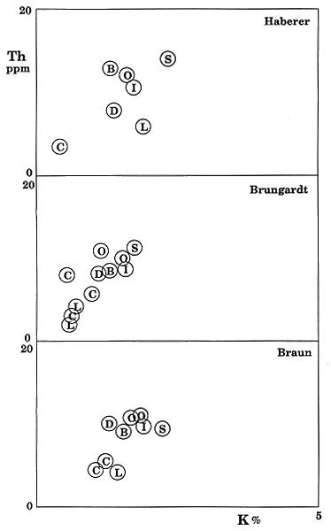
The facies of the Dakota Aquifer formations have a similar thorium-potassium crossplot character when compared between the borehole sections. However, there appears to be a systematic change in the channel facies, with a progressive decrease in implied clay content moving eastwards. Other differences are minor, but their significance may be obscured by the coarse averaging of the relatively thick sections which represent each facies.
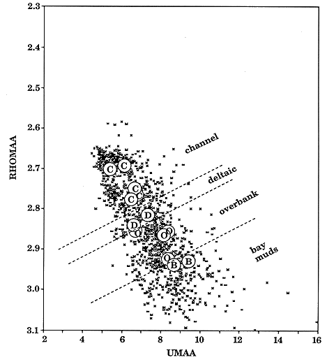
The RHOMAA-UMAA data from the Braun and Brungardt boreholes were pooled in a single crossplot and indexed with the facies of the Dakota aquifer formations (Figure B.21). There is a perfect discrimination of the four facies along the trend ranging from quartz to clay minerals. The ordering of bay, overbank, deltaic and channel is almost certainly a reflection of relative quartz silt content. This, in turn, is controlled by the relative energies of these environments in the transport of clastic materials within the delta complex.
Figure B.21. Combined RHOMAA-UMAA plot for Braun and Brungardt boreholes indexed with average facies locations.
The principal results to date have focused on the characterization of mineralogy and redox potential implied by the log combinations as described in detail within this appendix. There are clear log distinctions between and within the shaly units that appear to be indicators of changes in clay-mineral facies. Numerical tranformations of the raw logs have provided clay-mineral profiles which appear to contrast kaolinitic from illitic facies. There are also useful indicators of chlorite and smectite. These results will be tested and calibrated by laboratory analyses of core and cuttings samples, which will provide the necessary "ground truth." The relationship between throium and uranium serves an interpretative measure of redox potential, either at the time of deposition and/or subsequent diagenesis. The Th/U ratio of the Dakota section shows rapid changes that are linked with variability between sedimentary environments. The combination of all the log measurements will be most useful in the distinction of sedimentary facies and spatial correlation of units.