Kansas Geological Survey, Open-File Rept. 90-27
Annual Report, FY89--Appendix A
Use "Back" on your browser to return to the page you were viewing.
Each gamma-ray log in the data base was digitized from the paper copy by RLB Consultants, Independence, Kansas. The data was stored on double-density floppy discs for PC use and were copied onto four 1600 BPI tapes for use on the KGS Data General MV20000 computer.
Using the paper copies of the gamma-ray logs, depths to the top of 10 selected geologic formations in the Cretaceous and Permian systems were determined for each log. Depths to formation tops were also added from 38 test-hole lithologic logs from north-central Kansas described in KGS Bulletins. Modern calibrated gamma-ray logs are not available for these test holes. Formation tops were tabulated in a data file called GAM.XYZDPTH (see Table A.1 for format and geologic formations selected). Using this data, two other files were created tabulating elevations above sea level of the 10 formations and thicknesses of six of the formations. These are called GAM.XYZZZ (see Table A.2) and GAM.XYTHCK (see Table A.3) respectively.
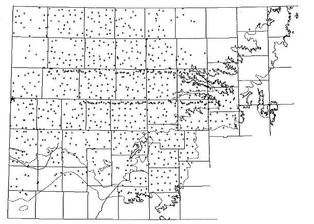
Figure A-1. Distribution of data in the geophysical-log data base.
The contouring system SurfaceIII (Sampson, 1988) was used with the files GAM.XYZZZ and GAM.XYTHCK to create contoured surface and isopach (thickness) maps for various formations listed in the respective files.
An additional file called KDEL.XYZ (see Table A.4) listing the elevation of the top of the Dakota Formation at over 5700 different locations, mostly in the outcrop/subcrop zone, was compiled from the data sources listed below:
Table A.1. Description and Format of GAM.XYZDPTH (Depths to Top of 10 Geologic Formations)
| Record Position | Description |
|---|---|
| 01-13 | Legal location (township, range, section, quarter) |
| 14-36 | Gimmap x and y coordinates |
| 37-41 | Elevation of datum above sea level |
| 42-46 | Depth to top of Carlile Shale (Kc) |
| 47-51 | Depth to top of Greenhorn Limestone (Kgh) |
| 52-56 | Depth to top of Graneros Shale (Kgr) |
| 57-61 | Depth to top of Dakota Formation (Kd) |
| 62-66 | Depth to top of Kiowa Shale (Kk) |
| 67-71 | Depth to top of Morrison Formation (Jm) |
| 72-76 | Depth to top of Upper Permian (Pu) |
| 77-81 | Depth to top of Cedar Hills (Pch) |
| 82-86 | Depth to top of Salt Plains (Psp) |
| 87-91 | Depth to top of Stone Corral (Psc) |
Table A.2. Description and Format of GAM.XYZZZ (Elevations of Tops of 10 Geologic Formations)
| Record Position | Description |
|---|---|
| 01-13 | Legal location (township, range, section, quarter) |
| 14-36 | Gimmap x and y coordinates |
| 37-41 | Elevation of datum above sea level |
| 42-46 | Elevation of top of Carlile Shale (Kc) |
| 47-51 | Elevation of top of Greenhorn Limestone (Kgh) |
| 52-56 | Elevation of top of Graneros Shale (Kgr) |
| 57-61 | Elevation of top of Dakota Formation (Kd) |
| 62-66 | Elevation of top of Kiowa Shale (Kk) |
| 67-71 | Elevation of top of Morrison Formation (Jm) |
| 72-76 | Elevation of top of Upper Permian (Pu) |
| 77-81 | Elevation of top of Cedar Hills (Pch) |
| 82-86 | Elevation of top of Salt Plains (Psp) |
| 87-91 | Elevation of top of Stone Corral (Psc) |
Table A.3. Description and Format of GAM.XYTHCK (Thicknesses of 6 Geologic Formations)
| Record Position | Description |
|---|---|
| 01-13 | Legal location (township, range, section, quarter) |
| 14-36 | Gimmap x and y coordinates |
| 37-41 | Thickness of Graneros Shale (Kgr) |
| 42-46 | Thickness of Dakota Formation (Kd) |
| 47-51 | Thickness of Kiowa and Cheyenne (Kk) |
| 52-56 | Thickness of Morrison Formation (Jm) |
| 57-61 | Thickness of Upper Permian (Pu) |
| 62-66 | Thickness of Cedar Hills (Pch) |
Table A.4. Description and Format of KDEL.XYZ (Elevation Above Sea-Level of the Top of the Dakota Formation)
| Record Position | Description |
|---|---|
| 01-13 | Legal location (township, range, section, quarter) |
| 14-36 | Gimmap x and y coordinates |
| 37-41 | Elevation of top of Dakota Formation (in feet) |
Figure A-2.Distribution of water-level data used to produce the predevelopment potentiometric surface of the Dakota aquifer.
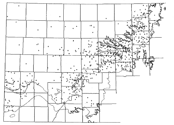
Table A.5. Description and Format of file WL.XYZ (Water Levels in the Lower Cretaceous Aquifer System)
| Record Position | Description |
|---|---|
| 01 | USGS file membership:
blank = working file only; 2 = project file and working file; 3 = data base, project file, and working file. |
| 02 | * = water level on same line was selected for USGS project mapping |
| 03-12 | Legal location (township, range, section, quarter) |
| 13-37 | Gimmap x and y coordinates |
| 38-41 | County code (see U.S. Department of Commerce, 1979) |
| 42-46 | Geohydrologic unit code name (see table 1, USGS Open-FileReport 87-396, 1987) |
| 47-54 | USGS geologic unit code (see table 1, USGS Open-File Report 87-396, 1987) |
| 55-56 | Importance of formation as a source of water to the well:
P = primary; S = secondary; N = noncontributing; U = unknown |
| 57-64 | Depth to top of formation |
| 65-72 | Altitude of land surface |
| 73-80 | Depth to bottom of well |
| 81-88 | Depth to top of screened interval |
| 89-96 | Depth to bottom of screened interval |
| 97-104 | Depth to bottom of casing |
| 105-112 | Depth to water |
| 113-120 | Altitude of water level |
| 121-131 | Date of water-level measurement in order of month/day/year |
| 132 | Source of data:
A = Static water level from aquifer test; P = Static water level from production test; G,L, or R = post-1929 measured water level; O = pre-1930 measured water level (location of well generally uncertain) |
The ground-water-quality data base is the most complex of the data bases needed in the Dakota aquifer investigation. The reason is that while geophysical, geologic, water-use, and water-level files may each have tens of different types of data entries for each record, the water-quality file has thousands of different entries possible for each record. The main component of the many quality entries is the thousands of different types of chemical properties, inorganic constituents and species, and organic compounds that can be determined.
Adding to the complexity of the data base is the different way in which many constituents and chemical properties can be measured and reported. For example, different analytical techniques have been used at different times to determine constituents and may give different results because they combine or exclude different species of the same element. In other cases, the analyses either represent the dissolved concentration of a constituent or the total content in a water (both the dissolved amount of the substance and that in the particulate matter included with the sample). The latter analysis is required for drinking water purposes because it is representative of the actual water consumed by the public. A dissolved concentration is more appropriate for determining the geochemistry of the aquifer water.
Some measurements are made in the field for unstable properties and constituents such as pH. Determinations of some of these properties and constituents in the laboratory may or may not be as good as the field values depending on the time since collection and preservation method. In cases where laboratory values are still valuable estimates of somewhat unstable properties and substances, a laboratory designation is attached to the analysis while a field code is included with the field measurement. Some determinations for the same constituent may be reported in different ways, for example, concentration in mg/L or microg/L and nitrate content expressed either as nitrate or nitrate-nitrogen. Finally, there may be different types of qualifications on the determination, including estimated values, less or greater than a certain value, determined but not detected, and quality control/assurance indications.
The U.S. Geological Survey uses a variable-length record for water-quality data, whether surface or ground water. Each record includes a sequence of analysis information before the actual chemical data. Each chemical property and constituent, reporting units, analytical method of analysis, and field or laboratory determination where appropriate are designated by a 5 digit parameter code. The current code list ranges from 00001 to 99830. Optional remarks codes for qualifications on the measurement, quality assurance, method, and precision accompany the parameter code and the value for a property or constituent. The advantage of the variable-length record is that only the properties and constituents for which there are data are included in the record. A powerful relational data-base management system is needed for this purpose that operates on the mainframe computers at the national centers of the USGS and on super minicomputers at the district offices of the Water Resources Divisions.
The Kansas Department of Health and Environment uses a water-quality data-base system with a fixed-length record for surface and ground waters. Each record containing values for water-quality properties and constituents is 3,040 characters long. The quality record is referenced through the data-base management system to a station master file that contains location and some other site information, as well as links to other files. The quality record begins with 80 characters of location, time, laboratory, and matrix information for sample collection and analysis. Specific positions containing 10 spaces each for measurement values of 296 different chemical properties and constituents follow the initial information.
The 296 properties and constituents are those that KDHE must measure for water-supply and waste-site purposes and are on the list of STORET parameter codes that are used by the U.S. Environmental Protection Agency. The STORET and USGS parameter codes are the same. The chemical substances in the KDHE file include both inorganic and organic constituents. The categories of inorganic substances are mainly common constituents and metals, including those designated as priority pollutants. The organic compounds primarily comprise pesticides and volatile, acid, and base-neutral priority pollutants. Not all of the 296 positions are currently assigned to a specific chemical property or substance; several are vacant for future use.
The KDHE system of fixed-length records results in much vacant space in the data file. The data base operates on the State main frame computer in Topeka. Minicomputers are used to process data that is put on and taken from the main computer.
Kansas Geological Survey Ground-Water-Chemistry Data-Base System (KWATCHEM)
A data-base system for ground-water chemistry was developed for the Kansas Geological Survey as a part of the Dakota Aquifer Program. The system operates in the INFO relational data-base management software on the Data General MV-20000 computer. The INFO system is part of the ARC/INFO package obtained during 1989 at the Survey. Unfortunately, the INFO system cannot handle variable-length records. The Survey had attempted to obtain a more powerful relational data-base management system that could handle variable-length records, but the cost was too high for the current budget. Thus, the data-base system for ground-water quality had to be formed with the limitation of fixed-length records.
The number of chemical properties and constituents that the KGS could potentially use in water investigations is estimated as over several hundred. A logic of efficiency and economy of computer space and processing as well as flexibility was used during the development. First of all, the data base was constructed to be for subsurface waters only, thereby decreasing the amount of information needed for describing surface-water sites and samples. The resultant data base was designed for subsurface water samples taken from both the vadose (unsaturated) and the saturated zone, including ground waters as well as formation waters that have been sampled during petroleum exploration or production (oil-field brines).
The structure of the data base involves two types of files, (1) a master file containing information on the site characteristics including type and use of sampling site, sample geographic location (x, y data), and sample depth location (z data), and (2) a series of analytical files containing site identification reference, sample collection information, and chemical measurements. A record in the master file (Table A.6) exists for each unique sampling location (record positions 2-17). A sample location in latitude-longitude coordinates (record positions 2-14 in Table A.6) may have the same geographic location as another sample location, but a different depth, as in the case of multiple wells within tens of feet of each other or within a single borehole, or an individual well with multiple sample intervals. The master file for an unique location is structured such that a well or borehole sequence number (record positions 15-16) is used to indicate different holes or wells if more than one well or hole has the same geographic location, and a depth sequence letter (record position 17 for multiple sample intervals in one borehole or well. Thus, the file can handle different wells close to each other and with the same depth, such as a replacement well.
Table A.6 Master File for Site Locations in the KWATCHEM Water-Quality Data-Base System.
| Record position | USGS code | Description |
|---|---|---|
| 1 | File number | |
| 2-14 | Site ID - Lat, Long (deg, min, sec), same as USGS | |
| 15-16 | Site ID - well or borehole sequence number, same as USGS | |
| 17 | Site ID - sample depth sequence letter | |
| 18-20 | County code - USGS number | |
| 21-34 | Township Range Section ABCD (to 2.4 acre tract) | |
| 35-38 | Feet west of southeast corner of section | |
| 39-42 | Feet north of southeast corner of section | |
| 43-49 | X dimension - ARC/INFO conversion from longitude | |
| 50-56 | Y dimension - ARC/INFO conversion from latitude | |
| 57 | Medium code (soil water, spring, ground water, oil brine) | |
| 58-65 | Geologic unit code - USGS | |
| 66-67 | State drainage basin number | |
| 68-75 | Drainage basin code - USGS | |
| 76-82 | 72000 | Elevation of land surface, ft (F6.1) |
| 83-90 | 72001 | Depth of hole, total, ft (F7.1) |
| 91-98 | 72008 | Depth of well, total, ft (F7.1) |
| 99-106 | 00003 | Sampling depth, middle of interval, ft (F7.1) |
| 107-114 | 72015 | Depth of top of sample interval, ft (F7.1) |
| 115-122 | 72016 | Depth to bottom of sample interval, ft (F7.1) |
| 123-130 | 72002 | Depth to top of water bearing zone sampled, ft (F7.1) |
| 131-138 | 72003 | Depth to bottom of water bearing zone sampled, ft (F7.1) |
| 139 | Well, borehole, or lysimeter use or type - USGS code | |
| 140 | Water use - USGS code | |
| 141-212 | Descriptive location name, other site information | |
| 213-216 | Site file record number |
The resolution of the geographic location is to the nearest second of latitude and longitude, giving an areal rectangle of about 80 by 100 feet in Kansas. The legal location can be recorded to the nearest 1/256 of a section (2.5 acre for square-mile sections) in the master file (record positions 21-34) which is less accurate (larger) than the latitude-longitude rectangle. The latitude-longitude was selected as the site identification for the geographic location for this reason and also because it is the same identification that the USGS uses in their data-base system. Space was also provided in the master file for the county code (USGS system) in record positions 18-20, and feet west and feet north of the southeast corner of a section in record positions 35-38 and 39-42, respectively.
If only the legal location accompanies a record, the KGS computer program LEO is used to generate the latitude-longitude values for the file. Thus, many records are not actually accurate to the nearest second of latitude and longitude. The LEO program takes into account the many odd-shaped sections in Kansas. The Survey has continued to improve this program to more accurately convert section locations to latitude-longitude values. A problem that remains in the conversion, however, is that several different ways of recording legal locations exist. For example, if an odd-shaped section has sides that are not close to being perpendicular to one another and are not parallel to north-south and east-west lines, the different procedures for determining quarter sections and feet west and north of the southeast corner of a section could result in different locations, and therefore different latitude-longitude site identifications for a well.
The medium code in the master file indicates the type of sample site. Codes can be entered for unsaturated zone waters such as sampled from soil-suction lysimeters, for ground waters, and for brines produced during oil and gas extraction. The geologic unit code system used is the same as that of the USGS. Spaces for the State drainage-basin number and USGS drainage-basin code are provided to aid in rapidly assembling data for selected drainage basins. Both the use or type of the sample location and the water can also be entered according the same codes as used by the USGS.
Different depth-related or z-dimension data can be entered in a series of fields from record positions 76-138. They range from elevation of the land surface to depths of the borehole, well, and sample interval to depths of the top and bottom of the aquifer. This information is also coded according to the USGS data-base system for easier transfer of data.
A record in the analytical files represents a water sample collected at a site at a particular time. There are currently 8 analytical files in KWATCHEM (Tables A.7-A.14). Many unique sampling sites have multiple records due to collection on different dates, thus, the number of sample records in the analytical files exceeds the number of sample sites in the master file. Each analytical record can be related to the master file through the site identification, i.e., the latitude-longitude, well sequence number, and depth sequence letter that appear in the same positions (2-17) at the beginning of each analytical file as in the master file. The sample collection date and time follows the site identification. The sequence year, month, day is used because that is the order of search for dates. The full year number is entered because in about 10 years the number will change to 2000; use of only the last two digits of the year would allow confusion of early date in the 20th century with those in the 21st century.
Information on the agencies collecting and analyzing the samples is entered according to USGS codes. Positions are also provided for the laboratory sample number and the analysis status, such as under review, use in ongoing project only, or completed and ready for public release.
The rest of the data in the analytical files, starting with record position 48, is for physical-chemical properties and chemical concentrations. The maximum length of each file was set at 255 positions, the maximum operable line length in many text processing programs. Each analytical file contains a logical grouping of different chemical information. The chemical data are identified according to USGS parameter codes used in their WATSTORE system and in the U.S. EPA STORET system for water-quality data.
The first analytical file is called the major properties file (Table A.7). Physical and chemical properties for which entries can be made include temperature, conductance, pH, Eh, and specific gravity. Fields for dissolved solids concentration and common calculated characteristics of waters such as hardness and sodium adsorption ratio are also in the file.
Table A.7 Analytical File in the KWATCHEM Water-Quality Data-Base System for Major Physical and Chemical Properties.
| Record position | USGS code | Description |
|---|---|---|
| 1 | File number | |
| 2-14 | Site ID - Lat, Long (deg, min, sec), same as USGS | |
| 15-16 | Site ID - well or borehole sequence number, same as USGS | |
| 17 | Site ID - sample depth sequence letter | |
| 18-25 | Collection date - Year (1989) Mon (05) Day (05) | |
| 26-29 | Time - 24 hour clock | |
| 30-34 | 00027 | Agency collecting sample, USGS code |
| 35-39 | 00028 | Agency analyzing sample, USGS code |
| 40-46 | Lab number | |
| 47 | Analysis status | |
| 48-57 | 00010 | Temperature, deg C |
| 58-67 | 00095 | Specific conductance, field, microS/cm at 25 deg C (F8.0) |
| 68-77 | 90095 | Specific conductance, lab, microS/cm at 25 deg C (F8.0) |
| 78-87 | 00400 | pH, field or on chilled sample <24 hours old in lab (F8.2) |
| 88-97 | 00403 | pH, lab (F8.2) |
| 98-107 | 00515 | Total-dissolved solids, residue at 105 deg C, mg/L (F8.1) |
| 108-117 | 70300 | Total-dissolved solids, residue at 180 deg C, mg/L (F8.1) |
| 118-127 | 70301 | Total-dissolved solids, sum of constituents, mg/L (F8.1) |
| 128-137 | 00931 | Sodium adsorption ratio, SAR (F8.2) |
| 138-147 | 00932 | Percent sodium (F8.2) |
| 148-157 | 00900 | Hardness, total, mg/L as CaCO3 (F8.1) |
| 158-167 | 00901 | Hardness, carbonate, mg/L as CaCO3 (F8.1) |
| 168-177 | 00902 | Hardness, non-carbonate, mg/L as CaCO3 (95902) (F8.1) |
| 178-187 | 00090 | Eh, oxidation potential, mV (F8.1) |
| 188-197 | 72013 | Specific gravity (F8.4) |
Table A.8 Analytical File in the KWATCHEM Water-Quality Data-Base System for Dissolved Concentrations of Major and Minor Inorganic Constituents Commonly Determined by the KGS and USGS.
| Record position | USGS code | Description |
|---|---|---|
| 1 | File number | |
| 2-14 | Site ID - Lat, Long (deg, min, sec), same as USGS | |
| 15-16 | Site ID - well or borehole sequence number, same as USGS | |
| 17 | Site ID - sample depth sequence letter | |
| 18-25 | Collection date - Year (1989) Mon (05) Day (05) | |
| 26-29 | Time - 24 hour clock | |
| 30-34 | 00027 | Agency collecting sample, USGS code |
| 35-39 | 00028 | Agency analyzing sample, USGS code |
| 40-46 | Lab number | |
| 47 | Analysis status | |
| 48-57 | 00915 | Ca, dissolved, mg/L (F8.1) |
| 58-67 | 00925 | Mg, dissolved, mg/L (F8.2) |
| 68-77 | 00930 | Na, dissolved, mg/L (F8.1) |
| 78-87 | 00933 | Na + K, dissolved, mg/L (old by difference calculation) (F8.1) |
| 88-97 | 00935 | K, dissolved, mg/L (F8.2) |
| 98-107 | 39086 | Alkalinity, dissolved, total, lab, mg/L (F8.1) |
| 108-117 | 00440 | Bicarbonate, field or chilled sample 48 hours old, mg/L (99440) (F8.1) |
| 118-127 | 90440 | Bicarbonate, lab (00453, 95440) (F8.1) |
| 128-137 | 00445 | Carbonate, field or chilled sample <24 hours old, mg/L (99445) (F8.1) |
| 138-147 | 90445 | Carbonate, lab, mg/L (95445) (F8.1) |
| 148-157 | 00940 | Chloride, dissolved, mg/L (F8.1) |
| 158-167 | 00945 | Sulfate, dissolved, mg/L (F8.1) |
| 168-177 | 00631 | Nitrate plus nitrite, dissolved, mg/L as N (F8.3) |
| 178-187 | 71851 | Nitrate, dissolved, mg/L as NO3 (F8.3) |
| 188-197 | 00950 | Fluoride, mg/L (F8.2) |
| 198-207 | 00955 | Silica, dissolved, mg/L as SiO2 (F8.2) |
| 208-217 | 00608 | Ammonia, dissolved, mg/L as N (F8.3) |
| 218-227 | 71846 | Ammonia, dissolved, mg/L as NH4 (F8.3) |
| 228-237 | 00671 | Orthophosphate, dissolved, mg/L as P (F8.3) |
| 238-247 | 00660 | Orthophosphate, dissolved, mg/L as PO4 (F8.3) |
The second analytical file contains values for the dissolved concentrations of major and minor inorganic constituents commonly determined by the KGS and USGS (Table 5.9). The third file comprises the total concentrations of major and minor inorganic substances that the Kansas Department of Health and Environment (KDHE) commonly determines in water samples (Table A.9). The KDHE measures total concentrations because its main concerns relate to health, i.e., a person drinking water consumes constituents present in both the dissolved and particulate form. The KGS and USGS are generally more interested in the dissolved forms of the constituents to allow determination of water-rock interactions. Samples are usually filtered through 0.45 um membrane filters to separate the particulates from the sample before analysis for dissolved substances.
Table A.9 Analytical File in the KWATCHEM Water-Quality Data-Base System for Total Concentrations of Major and Minor Inorganic Constituents Commonly Determined by the KDHE.
| Record position | USGS code | Description |
|---|---|---|
| 1 | File number | |
| 2-14 | Site ID - Lat, Long (deg, min, sec), same as USGS | |
| 15-16 | Site ID - well or borehole sequence number, same as USGS | |
| 17 | Site ID - sample depth sequence letter | |
| 18-25 | Collection date - Year (1989) Mon (05) Day (05) | |
| 26-29 | Time - 24 hour clock | |
| 30-34 | 00027 | Agency collecting sample, USGS code |
| 35-39 | 00028 | Agency analyzing sample, USGS code |
| 40-46 | Lab number | |
| 47 | Analysis status | |
| 48-57 | 00916 | Ca, total, mg/L (F8.1) |
| 58-67 | 00927 | Mg, total, mg/L (F8.1) |
| 68-77 | 00929 | Na, total, mg/L (F8.1) |
| 78-87 | 00937 | K, total, mg/L (F8.1) |
| 88-97 | 00410 | Alkalinity, total, field or chilled sample, mg/L as CaCO3 (F8.1) |
| 98-107 | 90410 | Alkalinity, total, lab, mg/L as CaCO3 (00417, 95410) (F8.1) |
| 108-117 | 00430 | Alkalinity, carbonate, field, mg/L as CaCO3 (99430) (F8.1) |
| 118-127 | 00940 | Chloride, dissolved, mg/L (F8.1) |
| 128-137 | 90945 | Sulfate, dissolved, mg/L (F8.1) |
| 138-147 | 00630 | Nitrate plus nitrite, total, mg/L as N (F8.3) |
| 148-157 | 00618 | Nitrate, total, mg/L as N (F8.3) |
| 158-167 | 00951 | Fluoride, total, mg/L (F8.2) |
| 168-177 | 00610 | Ammonia, total, mg/L as N (F8.3) |
| 178-187 | 00665 | Phosphorus, total, mg/L as P (F8.3) |
| 188-197 | 01022 | Boron, total, microg/L as B (F8.0) |
| 198-207 | 01045 | Iron, total, microg/L as Fe (F8.0) |
| 208-217 | 01055 | Manganese, total, microg/L as Mn (F8.0) |
| 218-227 | 01105 | Aluminum, total, microg/L as Al (F8.1) |
The fourth analytical file consists of dissolved concentrations of additional minor and trace inorganic constituents that the KGS or USGS may occasionally measure (Table A.10). The constituents include the metals iron, manganese, and aluminum, certain alkali and alkaline earth elements, and non-metals. The next file contains the dissolved concentration of dissolved trace metals (Table A.11). The sixth file is nearly identical to the fifth, except that the data is for the total contents of the trace metals as needed by the KDHE for assessment of water potability (Table A.12).
Table A.10 Analytical File in the KWATCHEM Water-Quality Data-Base System for Dissolved Concentrations of Minor and Trace Inorganic Constituents. Includes iron, manganese, and aluminum, alkale and alkaline earth elements, and non-metals.
| Record position | USGS code | Description |
|---|---|---|
| 1 | File number | |
| 2-14 | Site ID - Lat, Long (deg, min, sec), same as USGS | |
| 15-16 | Site ID - well or borehole sequence number, same as USGS | |
| 17 | Site ID - sample depth sequence letter | |
| 18-25 | Collection date - Year (1989) Mon (05) Day (05) | |
| 26-29 | Time - 24 hour clock | |
| 30-34 | 00027 | Agency collecting sample, USGS code |
| 35-39 | 00028 | Agency analyzing sample, USGS code |
| 40-46 | Lab number | |
| 47 | Analysis status | |
| 48-57 | 01020 | Boron, dissolved, microg/L as B (F8.1) |
| 58-68 | 01046 | Iron, dissolved, microg/L as Fe (F9.1) |
| 69-79 | 01047 | Iron, ferrous, dissolved, as Fe (F9.1) |
| 80-89 | 01056 | Manganese, dissolved, microg/L as Mn (F8.1) |
| 90-99 | 01106 | Aluminum, dissolved, microg/L as Al (F8.1) |
| 100-109 | 00613 | Nitrite, dissolved, mg/L as N (F8.3) |
| 110-119 | 71856 | Nitrite, dissolved, mg/L as NO2 (F8.3) |
| 120-129 | 00666 | Phosphorus, dissolved, mg/L as P (F8.3) |
| 130-139 | 01130 | Lithium, dissolved, microg/L as Li (F8.0) |
| 140-149 | 01135 | Rubidium, dissolved, microg/L as Rb (F8.1) |
| 150-159 | 01115 | Cesium, dissolved, microg/L as Cs (F8.1) |
| 160-169 | 01080 | Strontium, dissolved, microg/L as Sr (F8.0) |
| 170-179 | 01005 | Barium, dissolved, microg/L as Ba (F8.1) |
| 180-190 | 71870 | Bromide, dissolved, microg/L as Br (F8.0) |
| 191-201 | 71867 | Inorganic iodine, dissolved, microg/L as I (F9.1) |
| 202-212 | 71865 | Iodide, dissolved, microg/L as I (F9.1) |
| 213-222 | 71868 | Iodate, dissolved, microg/L as I (F8.1) |
Table A.11 Analytical File in the KWATCHEM Water-Quality Data-Base System for Dissolved Concentrations of Trace Metals.
| Record position | USGS code | Description |
|---|---|---|
| 1 | File number | |
| 2-14 | Site ID - Lat, Long (deg, min, sec), same as USGS | |
| 15-16 | Site ID - well or borehole sequence number, same as USGS | |
| 17 | Site ID - sample depth sequence letter | |
| 18-25 | Collection date - Year (1989) Mon (05) Day (05) | |
| 26-29 | Time - 24 hour clock | |
| 30-34 | 00027 | Agency collecting sample, USGS code |
| 35-39 | 00028 | Agency analyzing sample, USGS code |
| 40-46 | Lab number | |
| 47 | Analysis status | |
| 48-57 | 01095 | Antimony, dissolved, microg/L as Sb (F8.1) |
| 58-67 | 01000 | Arsenic, dissolved, microg/L as As (F8.1) |
| 68-77 | 01010 | Beryllium, dissolved, microg/L as Be (F8.2) |
| 78-87 | 01015 | Bismuth, dissolved, microg/L as Bi (F8.1) |
| 88-97 | 01025 | Cadmium, dissolved, microg/L as Cd (F8.2) |
| 98-107 | 01030 | Chromium, dissolved, microg/L as Cr (F8.1) |
| 108-117 | 01032 | Chromium, hexavalent, dissolved, microg/L as Cr (F8.1) |
| 118-127 | 01035 | Cobalt, dissolved, microg/L as Co (F8.1) |
| 128-137 | 01040 | Copper, dissolved, microg/L as Cu (F8.1) |
| 138-147 | 01049 | Lead, dissolved, microg/L as Pb (F8.2) |
| 148-157 | 71890 | Mercury, dissolved, microg/L as Hg (F8.2) |
| 158-167 | 01060 | Molybdenum, dissolved, microg/L as Mo (F8.1) |
| 168-177 | 01065 | Nickel, dissolved, microg/L as Ni (F8.1) |
| 178-187 | 01145 | Selenium, dissolved, microg/L as Se (F8.1) |
| 188-197 | 01075 | Silver, dissolved, microg/L as Ag (F8.2) |
| 198-207 | 01057 | Thallium, dissolved, microg/L as Tl (F8.1) |
| 208-217 | 01100 | Tin, dissolved, microg/L as Sn (F8.1) |
| 218-227 | 01150 | Titanium, dissolved, microg/L as Ti (F8.1) |
| 228-237 | 01085 | Vanadium, dissolved, microg/L as V (F8.1) |
| 238-247 | 01090 | Zinc, dissolved, microg/L as Zn (F8.1) |
Table A.12 Analytical File in the KWATCHEM Water-Quality Data-Base System for Total Concentrations of Trace Metals.
| Record position | USGS code | Description |
|---|---|---|
| 1 | File number | |
| 2-14 | Site ID - Lat, Long (deg, min, sec), same as USGS | |
| 15-16 | Site ID - well or borehole sequence number, same as USGS | |
| 17 | Site ID - sample depth sequence letter | |
| 18-25 | Collection date - Year (1989) Mon (05) Day (05) | |
| 26-29 | Time - 24 hour clock | |
| 30-34 | 00027 | Agency collecting sample, USGS code |
| 35-39 | 00028 | Agency analyzing sample, USGS code |
| 40-46 | Lab number | |
| 47 | Analysis status | |
| 48-57 | 01097 | Antimony, total, microg/L as Sb (F8.1) |
| 58-67 | 01002 | Arsenic, total, microg/L as As (F8.1) |
| 68-77 | 01007 | Barium, total, microg/L as Ba (F8.1) |
| 78-87 | 01012 | Beryllium, total, microg/L as Be (F8.2) |
| 88-97 | 01017 | Bismuth, total, microg/L as Bi (F8.1) |
| 98-107 | 01027 | Cadmium, total, microg/L as Cd (F8.2) |
| 108-117 | 01034 | Chromium, total, microg/L as Cr (F8.1) |
| 118-127 | 01037 | Cobalt, total, microg/L as Co (F8.1) |
| 128-137 | 01042 | Copper, total, microg/L as Cu (F8.1) |
| 138-147 | 01051 | Lead, total, microg/L as Pb (F8.2) |
| 148-157 | 71900 | Mercury, total, microg/L as Hg (F8.2) |
| 158-167 | 01062 | Molybdenum, total, microg/L as Mo (F8.1) |
| 168-177 | 01067 | Nickel, total, microg/L as Ni (F8.1) |
| 178-187 | 01147 | Selenium, total, microg/L as Se (F8.1) |
| 188-197 | 01077 | Silver, total, microg/L as Ag (F8.2) |
| 198-207 | 01059 | Thallium, total, microg/L as Tl (F8.1) |
| 208-217 | 01102 | Tin, total, microg/L as Sn (F8.1) |
| 218-227 | 01152 | Titanium, total, microg/L as Ti (F8.1) |
| 228-237 | 01087 | Vanadium, total, microg/L as V (F8.1) |
| 238-247 | 01092 | Zinc, total, microg/L as Zn (F8.1) |
The seventh analytical file includes concentration data for dissolved gases and miscellaneous properties and constituents related to drinking waters such as in the KDHE computer data system for water quality (Table 5.14). The last file presently in KWATCHEM contains fields for radioactive constituent concentrations and properties (Table 5.15). Additional analytical files that will be constructed in the future will include groups of organic substances in water. However, the Dakota aquifer program concerns mainly natural sources of constituents. The main current effect of anthropogenic activities on Dakota water quality are related to salinity from oil-field brines and from past agricultural practices that could affect nitrate and dissolved inorganic substances. More recent agricultural activities involving organic pesticides may also begin to affect water quality as recharge waters reach shallow portions of the Dakota aquifer. Table A.13 Analytical File in the KWATCHEM Water-Quality Data-Base System for Dissolved Gases and Miscellaneous Drinking Related Properties and Constituents in KDHE Water-Quality Data System.
| Record position | USGS code | Description |
|---|---|---|
| 1 | File number | |
| 2-14 | Site ID - Lat, Long (deg, min, sec), same as USGS | |
| 15-16 | Site ID - well or borehole sequence number, same as USGS | |
| 17 | Site ID - sample depth sequence letter | |
| 18-25 | Collection date - Year (1989) Mon (05) Day (05) | |
| 26-29 | Time - 24 hour clock | |
| 30-34 | 00027 | Agency collecting sample, USGS code |
| 35-39 | 00028 | Agency analyzing sample, USGS code |
| 40-46 | Lab number | |
| 47 | Analysis status | |
| 48-57 | 00299 | Oxygen, dissolved, polaragraphic probe, mg/L (F8.2) |
| 58-67 | 00300 | Oxygen, dissolved, chemical analysis, mg/L (F8.2) |
| 68-77 | 00746 | Sulfur, dissolved, mg/L as S (F8.2) |
| 78-87 | 71875 | Hydrogen sulfide, dissolved, mg/L as H2S (F8.2) |
| 88-97 | 00310 | BOD, Biochemical oxygen demand, 5-day at 20 deg C, mg/L (F8.2) |
| 98-107 | 00335 | COD, Chemical oxygen demand, 0.025N dichromate, mg/L (F8.2) |
| 108-117 | 00681 | Organic carbon, dissolved, mg/L as C (F8.2) |
| 118-127 | 00680 | Organic carbon, total, mg/L as C (F8.2) |
| 128-137 | 00720 | Cyanide, total, mg/L as CN (F8.2) |
| 138-147 | 81375 | Organic halogen, total, microg/L (F8.2) |
| 148-157 | 32730 | Phenols, total, microg/L (F8.2) |
| 158-167 | 38260 | Methylene blue active substance, mg/L (F8.2) |
| 168-177 | 00076 | Turbidity, NTU (F8.2) |
| 178-187 | 00530 | Suspended solids, residue at 105 deg C, mg/L (F8.1) |
| 188-197 | 74021 | Sodium bicarbonate alkalinity (F8.1) |
| 198-207 | 31501 | Coliform, membrane filter, immed. M-endo medium (col/100 mL) (F8.1) |
| 208-217 | 31616 | Fecal coliform, mem. filter, M-FC med. 44.5 deg (col/100 mL) (F8.1) |
| 218-227 | 31673 | Fecal streptococci, membrane filter, KF agar (col/100 mL) (F8.1) |
Table A.14 Analytical File in the KWATCHEM Water-Quality Data-Base System for Radioactive Constituents and Properties.
| Record position | USGS code | Description |
|---|---|---|
| 1 | File number | |
| 2-14 | Site ID - Lat, Long (deg, min, sec), same as USGS | |
| 15-16 | Site ID - well or borehole sequence number, same as USGS | |
| 17 | Site ID - sample depth sequence letter | |
| 18-25 | Collection date - Year (1989) Mon (05) Day (05) | |
| 26-29 | Time - 24 hour clock | |
| 30-34 | 00027 | Agency collecting sample, USGS code |
| 35-39 | 00028 | Agency analyzing sample, USGS code |
| 40-46 | Lab number | |
| 47 | Analysis status | |
| 48-57 | 01515 | Gross alpha radioactivity, dissolved, pc/L as U natural (F8.2) |
| 58-67 | 01516 | Gross alpha radioactivity, suspended total, pc/L as U natural (F8.2) |
| 68-77 | 03515 | Gross beta radioactivity, dissolved, pc/L as Cs-137 (F8.2) |
| 78-87 | 03516 | Gross beta radioactivity, suspended total, pc/L as Cs-137 (F8.2) |
| 88-97 | 80050 | Gross beta radioactivity, dissolved, pc/L as Sr/Yt-90 (F8.2) |
| 98-107 | 03517 | Gross beta radioactivity, suspended total, pc/L as Sr/Yt-90 (80060) (F8.2) |
| 108-117 | 22703 | Uranium, natural, dissolved, microg/L as U (F8.2) |
| 118-127 | 22705 | Uranium, natural, suspended total, microg/L as U (F8.2) |
| 128-137 | 80020 | Uranium, dissolved, extraction fluorometric, microg/L as U (F8.2) |
| 138-147 | 09511 | Radium, dissolved, radon method, pc/L (F8.3) |
| 148-157 | 09505 | Radium, suspended total, pc/L (F8.3) |
| 158-167 | 82305 | Radon 222, dissolved, pc/L (F8.2) |
| 168-177 | 82362 | Radon 222, dissolved gas, pc/L (F8.2) |
| 178-187 | 82303 | Radon 222, total, pc/L (F8.2) |
| 188-197 | 07005 | Tritium, dissolved, pc/L (F8.2) |
| 198-207 | 07018 | Tritium, dissolved, tritium units (F8.2) |
The data from KGS publications are mainly in the Bulletins, Chemical Series, and Irrigation Series, as well as from some recent publications. The Bulletins include data collected from the late 1930's to the early 1960's. The data collected during the 1970's are listed in the Chemical and Irrigation series. Table 5.16 lists KGS publications containing water-quality data that were examined for Dakota water analyses. Chemical analyses from recent KGS reports and generated during this study on the Dakota aquifer, including water samples collected and analyzed by Kansas State University during the irrigation efficiency study, were entered into the KWATCHEM data base.
Table A.15. Kansas Geological Survey publications for counties in Kansas where strata of the Dakota aquifer crop out or are present in the subsurface. The table shows the possible sources of water-quality data published by the Survey. Not all publications may actually include chemical data for the Dakota aquifer. The column for DB sites includes the number of sites containing water-quality data in the KWATCHEM data-base system.
| County | DB Sites | KGS Publications |
|---|---|---|
| Barton | 47 | Bull. no. 88, p. 118-121; OFR 88-39 |
| Cheyenne | 0 | CS no. 7 |
| Clark | 0 | |
Several different formatted computer data files were obtained from the USGS office. The working file and the subset of the working file called the QW file for the Dakota aquifer (Great Plains aquifer) portion of the Regional Aquifer System Analysis (RASA) program were obtained in an HN2 card-formatted format. A WATSTORE file for the Dakota was also obtained and was in a spreadsheet-formated file. A card-formatted file was also obtained in the 1-star version. A majority of the data currently in the KWATCHEM system for the Dakota study came from the USGS files. The files overlap one another. The time period of the data in each file is dependent upon the publishing date; the newer the version, the more data present.
Data from the EPA/KDHE in the STORET format were largely included in the USGS files, except for more recent data collected in 1985 - 1987.
A series of interactive FORTRAN programs were written to retrieve the data in different formats. The programs searched for chemical parameters codes and their associates values. The output format was modified to the form needed for data examination. Other programs were written to manipulate the data to keep remarks codes in a consistent form to allow comparison of data from different sources. Each data file was checked for duplication of records within itself by a computer program. The duplicate records were eliminated, and new unique-record files were created. These files were then compared for duplicate records among the different sources, and the duplicates were deleted.
The data also were checked by several approaches to make sure the data are reliable. The methods included calculations of cation-anion charge balance, comparison of measured and calculated total-dissolved solids concentrations and specific conductances (using the approximate fraction of 2/3 of the specific conductance in micromho/cm or microS equals the TDS in mg/L), comparison of the hardness content listed with that computed from the calcium and magnesium listed, comparison of the alkalinity reported with the bicarbonate concentration listed converted to alkalinity, comparison of the non-carbonate hardness with the alkalinity, and other comparisons. When a value was found that was inconsistent with the rest of the record, an attempt was made to find the probable original source of the data in a publication. Most of those found were in KGS bulletins and series. Any discrepancy in the computer file relative to a published record was then corrected. Most of the errors were found in the USGS working file used in the RASA study. However, a few errors were also found in the USGS WATSTORE data that the district and national offices of the USGS use. The following are specifics of most of the types of errors found in the data:
During the course of the data inspection and correction, additional data were found in previous publications that are not in the USGS or EPA computer files. These, and data recently generated as part of the KGS Dakota Program, were entered into the KWATCHEM files.
Location information for the corrected, unique records are stored in both latitude-longitude and township-range-section formats in KWATCHEM. possible problem encountered during the data-base development was the procedure for entering new records. The problem is the inconsistency of using a location-convert program. For example, the original well location is often expressed as a legal location. This location has to be converted to the global location system for projection to x and y coordinated for use in computer graphics programs. In other cases, digitized data may contain the latitude and longitude values. Location data in these records may have been generated by a different system than the KGS LEO conversion program or by an earlier version of this program, and therefore may not have exactly the same location numbers as the ones obtained from the current KGS LEO program. In order to make sure that a truly unique site is being entered, both longitude-latitude and by township-range-section information must be checked.