


Kansas Geological Survey, Open-file Report 88-39
Great Plains and Cedar Hills Aquifers--Page 10 of 25
Figure 19. Potentiometric surface of the Cedar Hills aquifer.
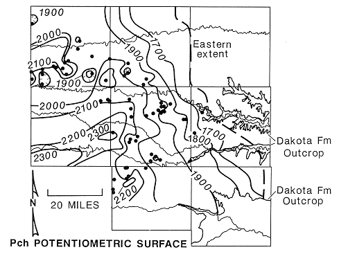
Pre-Cretaceous erosion has removed younger Permian-aged strata east of a north-northwest trending line that extends through western Ellis, Rooks, and Rush counties. Eastward of this line, the Cedar Hills underlies and is believed to be hydraulically interconnected with the Great Plains aquifer. Interconnection between the two aquifer systems is suggested by fundamental changes in the configuration of the potentio-metric surface eastward of this line (Figure 19). The direction of ground-water flow in the lower part of the Great Plains aquifer is distinctly subparallel with the eastward flow direction indicated for the Cedar Hills aquifer in this area.
Westward of the Cedar Hills subcrop, the potentiometric surface has been affected by the injection of oil-field brines and shows the effects of fluid pressure build-up in southern Trego, northwestern Rush, and western Graham counties. These areas of pressure build-up have resulted from coalescing areas of higher fluid pressure in the aquifer where injection is taking place and appear as a series of isolated highs in the potentiometric surface (Figure 19).
The potentiometric surface of the Cedar Hills aquifer is generally higher than the potentiometric surfaces in the upper and lower Great Plains aquifer over most of the study area. Hydraulic head differences on the order of 50 feet or more are common. However, only limited data on the these aquifers are available in Rooks and eastern Graham counties.
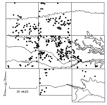
Recharge to the Cedar Hills aquifer is from two sources: underflow from areas southwest of the study area and injection of oil-field brines through disposal wells. Underflow to the Cedar Hills aquifer has not been estimated from due to the irregularity of the potentiometric surface. Recharge to the Cedar Hills aquifer from injection wells is estimated to have been approximately 6.9 ft3/sec. (5035 acre-feet per year) during the 1975-1983 period. Figure 20 shows the distribution of disposal wells in Russell, Ellis, Trego, Graham, Rooks, Osborne and Barton counties.
Figure 20. Distribution of shallow oil-field brine disposal wells in the study area.
Discharge from the Cedar Hills is believed to be to the overlying lower portions of the Great Plains aquifer east of R19W in the study area. Discharge from the Cedar Hills aquifer has not been estimated due to lack of information on the vertical component of hydraulic conductivity in the Great Plains and the Cedar Hills aquifers.
Static fluid level and injection pressure data gathered by the KCC suggest, at least theoretically, that hydraulic fracturing of the Cedar Hills aquifer may be taking place during injection at some of the disposal sites. Shown in Figure 21 are the results of a survey of shallow injection wells in Rush County conducted by KCC to determine the variation of fluid pressure in the vicinity of the well during injection. This was done by measuring static fluid levels and monitoring fluid pressures, during and after injection. Plotted on the figure are two lines showing the increase hydrostatic fluid pressure and lithostatic pressure with depth.
Figure 21. Injection fluid pressures versus depth below land surface for some Cedar Hills disposal wells western Rush County.
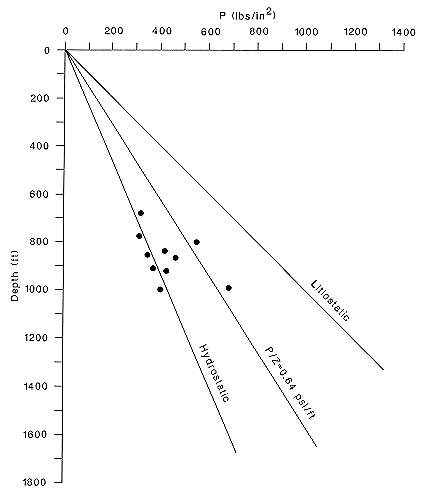
Also shown is a third line showing an increase in fluid pressure with depth of 0.64 psi/ft. Hubbert and Willis (1972) have shown that theoretically the minimum injection pressure-depth ratio required to initiate hydraulic fracturing (normal faulting in tectonically relaxed areas) in a well is approximately 0.64 psi/ft of depth for a homogeneous and isotropic porous media. This assumes an effective overburden pressure of 1.00 psi/ft which is typical for most sedimentary rocks. The total injection pressure is calculated as the sum of the fluid pressure in the formation and the applied injection pressure at the surface assuming no losses due to friction and fluid compression. Figure 21 shows that two of the injection wells surveyed have clearly exceeded the theoretical minimum injection pressure required for hydraulic fracturing. This theoretical minimum injection pressure/depth ratio may be low for flat-lying, lenticular formations if the rocks already contain fractures and other discontinuities (Lorenz et al., 1986).
Previous page--Great Plains Flow ||
Next page--Chemical Data Types
Start of Report ||
Report Contents