


Kansas Geological Survey, Open-file Report 88-39
Great Plains and Cedar Hills Aquifers--Page 3 of 25
Since the Dakota Group was defined by Meek and Hayden (1861) the name has been applied somewhat indiscriminantly to various sedimentary sequences composed of Lower Cretaceous sandstones and shales that may not all be time equivalent. Most of these early works have largely dealt with rocks exposed at the surface. The Cheyenne and Kiowa have been recognized as formations since they were defined by Cragin in 1889 and 1894, respectively (Latta, 1946). The Dakota has been officially recognized as a formation by the Kansas Geological Survey since 1942 when the term was restricted to cover the sequence between the base of the Graneros Shale and the top of the Kiowa Formation. Plummer and Romary (1942) subdivided the Dakota Formation into two members, the Janssen Clay member above and the Terra Cotta Clay member below, based on field work along the outcrop in central Kansas.
With the discovery of oil and the need to dispose of the produced brines, interest shifted to the subsurface. A reconnaissance investigation by Frye and Brazil (1943) was conducted to determine the hydrogeology of the unconsolidated and bedrock aquifers in Ellis and Russell counties. They mapped what they believed to be the easternmost extent of the Cheyenne Sandstone in western Russell County. Later, Swineford and Williams (1945) conducted a geologic and hydrologic investigation of the Lower Cretaceous in the same area at the request of the State Board of Health. Concern was expressed that insufficient geologic criteria were being used to approve the shallow disposal of oil-field brines in the Cheyenne Sandstone. Swineford and Williams examined drill cuttings and the light and dark fractions of insoluble residues in an attempt to differentiate the Cheyenne Sandstone from adjacent formations. They found that differences in grain size and roundness of the sandstone grains and the composition of the insoluble residue suite could be used to locate formational boundaries. Moreover, they revised the earlier work of Frye and Brazil by concluding that the Cheyenne Sandstone extends farther east of western Russell County than the earlier investigation had indicated.
Much later, Merriam (1957) renamed the Dakota Formation the Omadi in an attempt to correlate the Kansas Lower Cretaceous rock section with the same section as defined farther north in Nebraska. He defined three members which are, from oldest to youngest, the Cruise, the Huntsman, and the Gurley. In this scheme, the Dakota was elevated to group status including, from oldest to youngest, the Cheyenne, the Kiowa, and the Omadi Formations. These formational names were applied to the subsurface by Merriam (1957; 1963) and used to show the stratigraphic relationships between the various Mesozoic-age rock units in the subsurface of western Kansas. This terminology has not been adopted by the Kansas Geological Survey.
Our present understanding of the stratigraphy and depositional environments in the Lower Cretaceous comes from fieldwork that was done along the central and southern Kansas outcrop in the decades of the 1960's, and 1970's. Franks (1966) mapped the Dakota and Kiowa Formations along the outcrop. Field mapping shows the contact between the Dakota and Kiowa Formations to be locally disconformable. In some cases, sharp contacts abruptly separate clay rocks of the Dakota Formation from sandstones and clay rocks in the Kiowa and, in other instances, basal sandstones in the Dakota rest on interbedded sandstones and clay rocks in the Kiowa. Franks has interpreted the upper portion of the Kiowa to be part of a regressive sequence of interbedded shales and sandstones. The upward increase in grain size and increase in kaolinite in the Kiowa marks the onset of regressive conditions. At the base of the Dakota, the occurrence of conglomeratic sandstones and red-mottled clay rocks signifies the development of alluvial depositional systems. Previously, Twenhofel (1920, 1924) and Tester (1931) had concluded that the two formations were laterally and vertically conformable and gradational. This conclusion was based on the occurrence of Kiowa sandstones containing leaf fossils similar to those found in the Dakota strata. The concept of the intertonguing of the two units led to the development of a large scale deltaic model of sedimentation involving the two formations.
Using the results of Scott (1970), Franks (1975, 1980) proposed a transgressive-regressive model of sedimentation to account for the distribution of lithofacies seen in the Cheyenne, Kiowa, and Dakota sequence of formations in Kansas. The Cheyenne Sandstone and Kiowa Formation record a northeastward transgression of the sea across Kansas. Sedimentation was governed by the type and rate of sediment supplied to the interior seaway and the rate of subsidence during early Kiowa time. These rocks were deposited in and near the eastern margins of the Early Cretaceous epicontinental sea that spread over the southern Western Interior.
Franks' (1975, 1980) interpretation of the geologic framework shows a progressive overlapping of older Lower Cretaceous stratigraphic units on the Cretaceous-Permian boundary from southwest to northeast across the Kansas outcrop. Accordingly, the Cheyenne Sandstone is present only in southern Kansas and does not extend in the subsurface very far northward of the outcrop. This contradicts the earlier work of Frye and Brazil (1943) and Swineford and Williams (1945) in the Ellis-Russell County area and Merriam (1957). These authors show that the Cheyenne Sandstone is present in much of the subsurface of western Kansas. However, Franks (1975, 1979 and 1980) believes that the lower part of the Kiowa Formation, the so-called "Longford member," resembles and has been confused with the Cheyenne Sandstone. These rock units are not time equivalent even though they are similar in aspect (Scott, 1970). Farther north the Kiowa Formation rests directly on the Cretaceous-Permian boundary. Near the Nebraska-Kansas border, in the north central part of the state, the Kiowa is not present and the Dakota rests directly on the Lower Permian.
Farther up the stratigraphic column in the upper part of the Dakota Formation, clay rocks of the Janssen member contain lenticular channel sandstones of the Rocktown Channel sandstone in north-central Kansas (Rubey and Bass, 1925). These rocks are interpreted as having been deposited in a deltaic complex under the influence of a transgressing Graneros sea (Hattin, 1965; Franks, 1965, 1975; Siemers, 1971, 1976). The Rocktown Channel sandstone body has been divided by Siemers into two major subfacies, grading within approximately 30 miles from a highly sinuous distributary channel sandstone into estuarine and delta-front sandstones. A lower cross-bedded sandstone subfacies is 54 to 66 feet thick and 900 to 1800 feet wide and is more less confined to a sinuous, elongated v-shaped trough whereas the upper flat-bedded subfacies forms a tabular-shaped unit. These rocks reflect an increasingly marine character in the style of sedimentation in the upper part of the Dakota westward of the outcrop as the Dakota intertongues with the Graneros Shale in northwest Kansas (Hattin and Siemers, 1987).
One of the earliest of these studies was conducted by Frye and Brazil (1943) in the oil-field areas of Ellis and Russell Counties. Their objective was to evaluate the resource potential of surface and ground waters and to assess the effects of oil-field activities on water quality. During the course of the study, several test holes were drilled into the Dakota and Kiowa Formations and the Cheyenne Sandstone in Russell and Ellis County. As the drilling of each test hole progressed, water samples and hydraulic head measurements were taken. The unpublished data from the test-hole drilling program shows that the vertical direction of ground-water flow is upward from the deeper aquifers in the Lower Cretaceous to shallow aquifers. The authors note that the chemical quality of ground waters in the Dakota is highly variable laterally and vertically.
A water sample collected from a deeper zone in the Lower Cretaceous in one of the test holes was analyzed and contained 22,900 mg/l chloride. However, a water sample taken from a nearby well in the Dakota contained a chloride concentration of only 23 mg/l. Additionally, water level measurements were taken in wells obtaining water from the Dakota and a map was prepared to show the potentiometric surface of the upper part of the Dakota in T14- 15S between R12-15W. The map clearly shows that ground waters from the upper part of the Dakota discharge to the Smoky Hill River in Russell County. As a part of their investigation, Frye and Brazil looked into the brine-disposal practices of the oil industry in Russell and Ellis Counties. They found that oil-field brines were being disposed in evaporation pits, shallow disposal wells drilled into the sandstones of Lower Cretaceous age (including the lower part of the Dakota Formation), and deep disposal wells drilled into porous rocks of Pennsylvanian age or older. They concluded that disposal of oil-field brines could be done safely in the Cheyenne Sandstone since sandstones in the Cheyenne constituted a stratigraphic trap. In contrast, sandstones in the Dakota were found not to be suitable because brines injected into the lower portions of the Dakota Formation would migrate upwards into the fresh water zones through interconnecting sandstone lenses.
Somewhat later, Swineford and Williams (1945) investigated the vertical variation of water quality in the Lower Cretaceous and Lower Permian in western Russell County, where Frye and Brazil (1943) had conducted their earlier investigation. During the drilling of test holes through the Lower Cretaceous and Lower Permian rocks, they collected water samples in order to determine the vertical variation of water quality in each borehole. They found a progressive increase in total dissolved solids (TDS) and chloride content with depth. Ground waters in the upper part of the Dakota were found to contain less than 9000 ppm TDS. In contrast, the TDS content of ground waters from the lower part of the Dakota Formation ranged from 9,000 to 61,000 mg/l. In the lower units the concentration of TDS in ground waters from the Kiowa and Cheyenne ranged from 33,000 to 62,000 mg/l and from 31,000 to 71,000 mg/l in the Permian red beds (Cedar Hills Sandstone). Figure 2 shows schematically the variation of TDS with depth considering all of the samples collected.
Figure 2. Composite water quality profile of the Lower Cretaceous and Permian bedrock aquifers in Russell County, generalized from test drilling. Adapted from Swineford and Williams (1945).
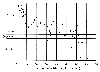
Most importantly, the authors were able to delineate hydrochemical zones in these aquifer units based on an interpretation of the water chemistry. They found that all of the water samples from the upper half and some from the lower half of the Dakota were distinctly different in constituent composition from those samples that came from the Kiowa, Cheyenne, and Cedar Hills. The authors interpret this variation in water chemistry to be the result of the mixing of sodium chloride brines from the lower units with formation waters in the lower half of the Dakota Formation. This is discussed further in section 6.2.3.
Noting the differences in water chemistry of the Lower Dakota between the oil-field areas and those areas on the edge of or away from the oil fields, Swineford and Williams also concluded that ground waters from the lower part of the Dakota have been affected by disposal of oil-field brines. They speculated that this could have occurred as a direct result of induced migration upwards from lower injection horizons in the Cheyenne and Cedar Hills Sandstones caused by the "pressuring up" of injection horizons or through unplugged or improperly plugged boreholes in the oil-field areas.
Later work by Latta (1948), Jordan et al. (1964), and Hargadine et al. (1979) found that mineralized waters from the Dakota Formation eventually discharge into the alluvial aquifers and surface waters of the Smoky Hill, Saline, and Solomon Rivers in north-central Kansas.
Concern for the protection of ground waters in the Dakota from contamination by oil-related activities and the lack of information about water quality in the Lower Cretaceous rocks (Great Plains aquifer system) has prompted several reconnaissance-level surveys using log analysis techniques to derive the salinity of ground water in northwest Kansas. Early work by the Kansas Geological Survey produced relative salinity maps of the upper and lower sandstones in the Cheyenne Sandstone (Anonymous, 1960). Relative salinity of the waters was calculated from a combination of SP, and long and short normal resistivity logs. The relative salinity was calculated because water samples from the Cheyenne Sandstone were not available to calibrate the calculated results. The results of this reconnaissance-level effort show considerable variability in ground-water salinity laterally and vertically in northwest Kansas. However, the author could not attribute the cause of this variation. Much later, Malone (circa 1984-85) produced a similar map showing the salinity of ground waters in the Dakota of northwest Kansas for Murfin Drilling Company, Wichita, Kansas. The map shows relatively fresh waters in the Dakota for Logan, Graham, Sheridan and parts of Decatur, Trego, and Norton counties. Waters in the Dakota are relatively saline in Cheyenne, Rawlins, Sherman, Thomas, and Wallace counties.
Several county and subregional reconnaissance studies that have dealt in part with the Great Plains aquifer system in the study area have also been completed. These include reports on southeastern Trego, southern Ellis, and northern Rush counties in the Smoky Hill valley (Leonard and Berry, 1961), Rush County (McNellis, 1973), and Trego County (Hodson, 1965). Within these areas the authors report widespread use of aquifers in the Dakota Formation for domestic and stock uses where other supplies are not available.
Perhaps the most important regional study of the Great Plains aquifer system has been conducted recently under the U.S. Geological Survey's CM RASA Program (Helgeson et al. in review). Using existing data, their study puts the hydrogeology and water quality of the Great Plains aquifer system in a regional perspective that covers parts of Kansas, Nebraska, Wyoming, Colorado, New Mexico, and Oklahoma. In an evaluation of the Lower Cretaceous bedrock aquifer system, they note that variation in the water chemistry of the Great Plains aquifer appears to be related largely to the degree that the aquifer has been flushed of formation waters. Calcium-bicarbonate and mixed cation-mixed anion type waters are found near the outcrop areas. Sodium-chloride type waters are contained in the aquifer either where these rocks are more deeply buried and have not been flushed by recharge waters, or where they are being recharged by saline waters from the underlying Permian.
Previous page--Introduction ||
Next page--SP Log
Start of Report ||
Report Contents